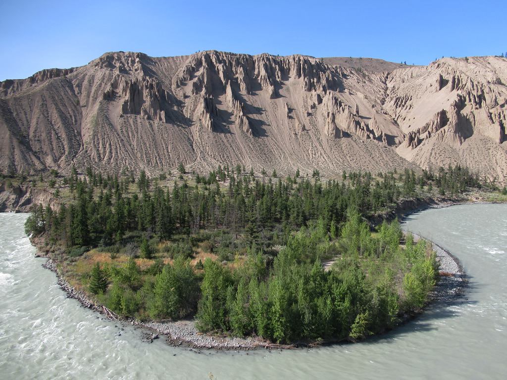
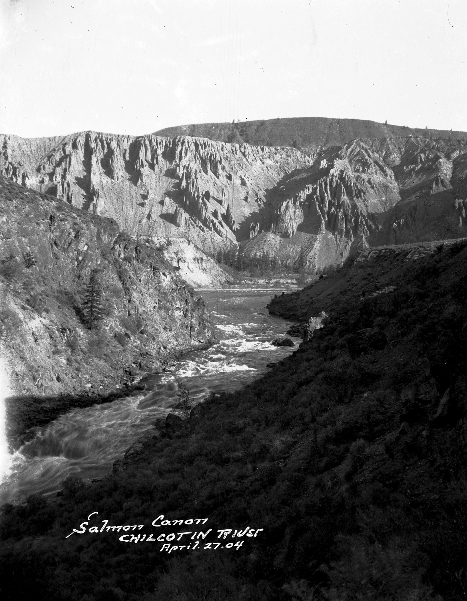
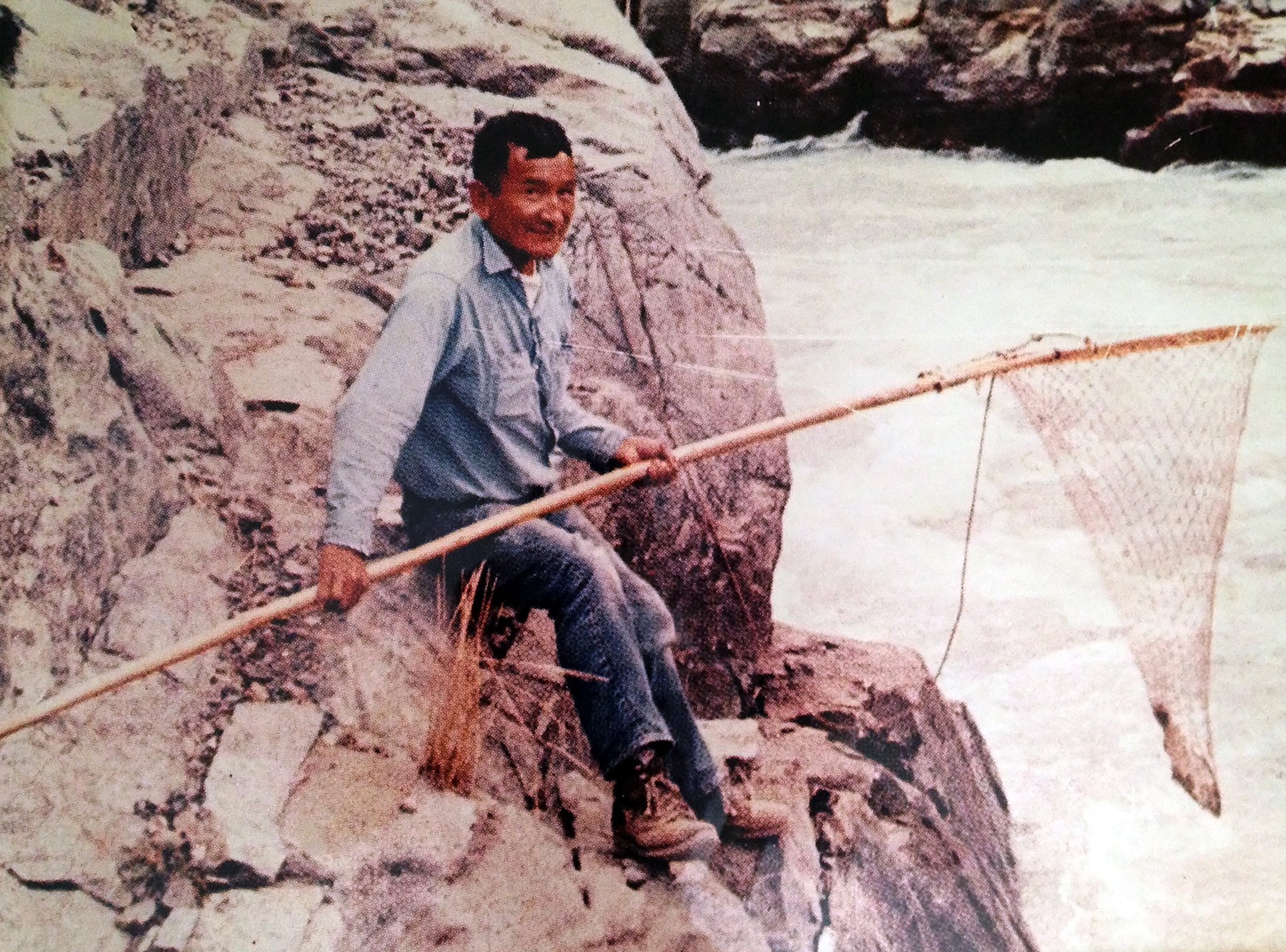
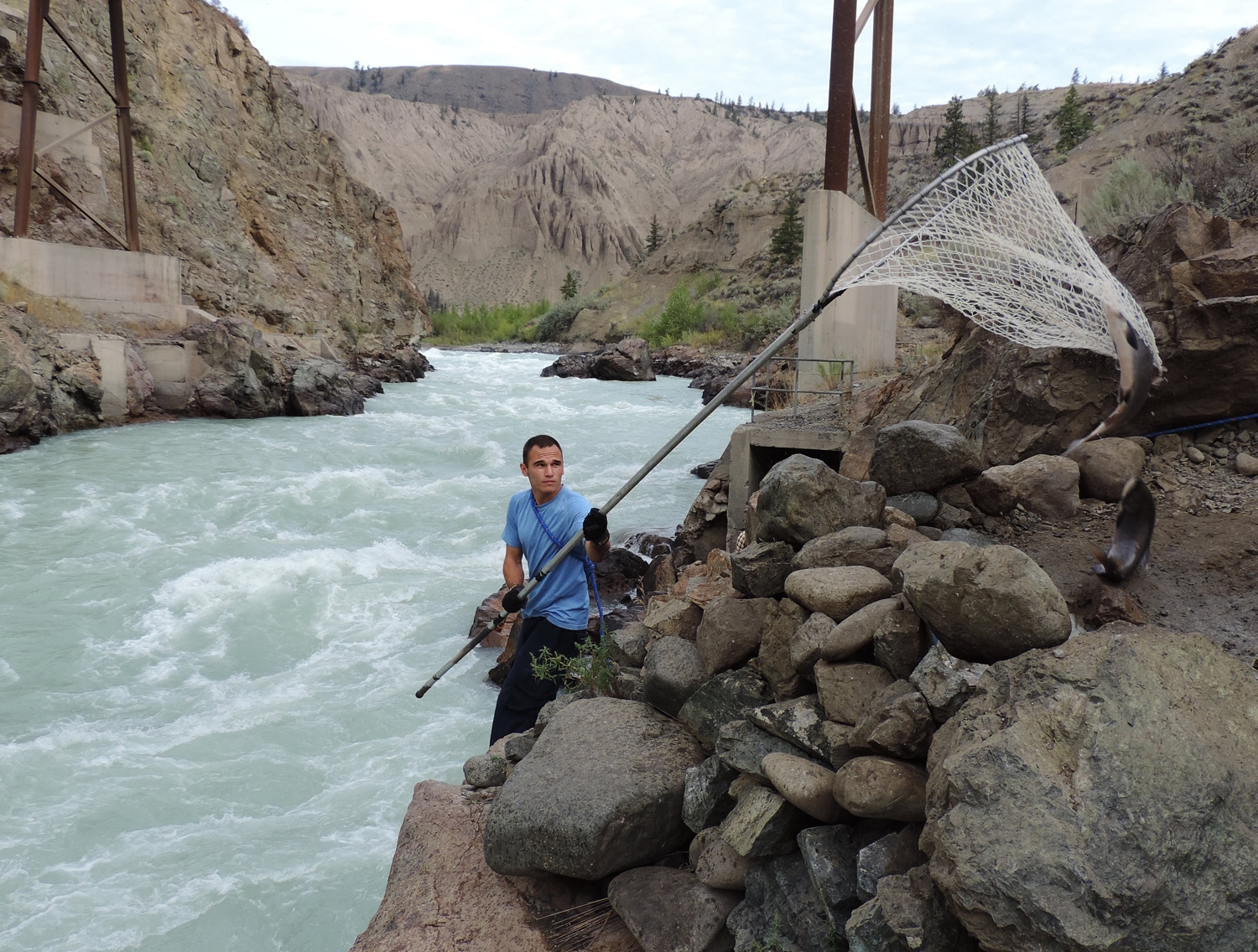
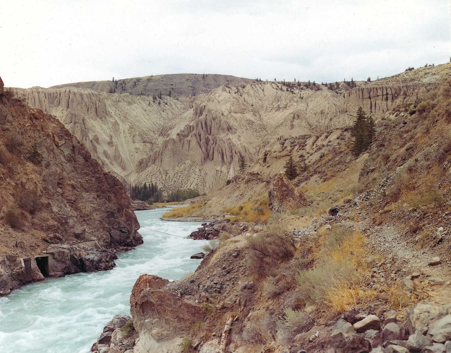
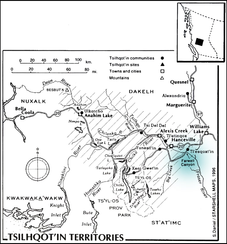
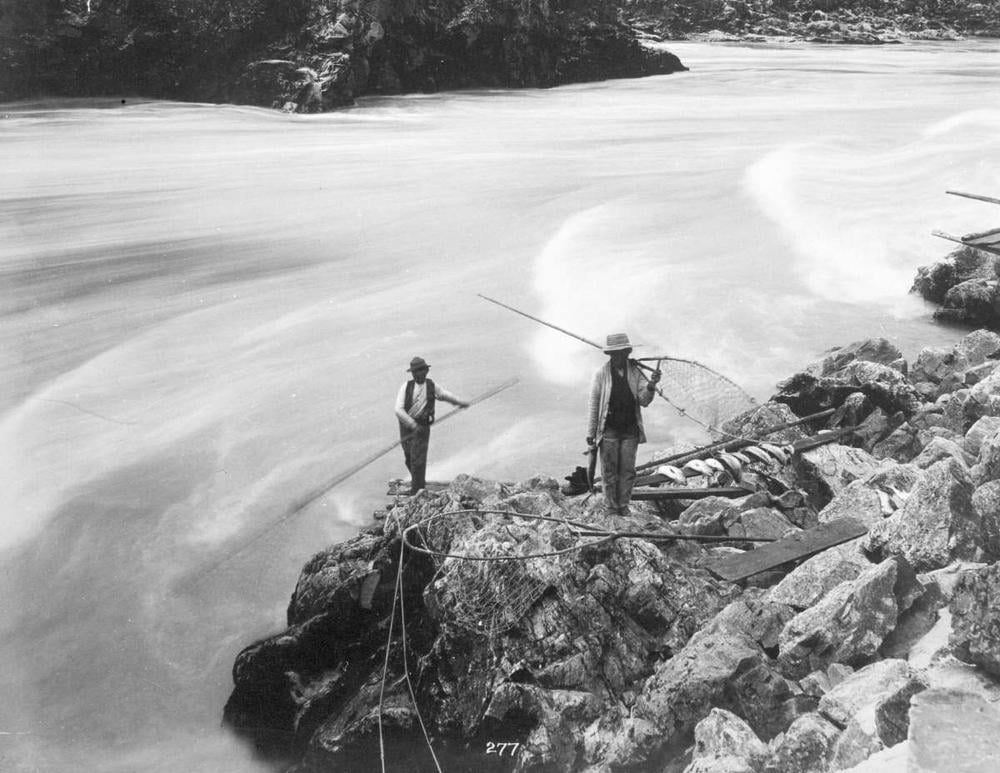
Farwell Canyon is one of the best river fishing spots in the interior of British Columbia. I know that’s a subjective claim, but it’s about as close to an objective statement as a fisherman has ever made about a fishing hole. When the salmon are running, any Indian with a status card proving they are a member of one of the many Secwépemc and Tsilhqot’in bands that fish this narrow stretch of the Chilcotin River can tie themselves to a rock, stick a dipnet in the water, and haul out fish. Because, at Farwell Canyon, the river bottlenecks, water rushes hard, and fish school up into tight runs to make the steep ascent to Chilko Lake. Where, if they are lucky enough to get past all the Indians and our nets, they will spawn and die, as all Pacific salmon species do.
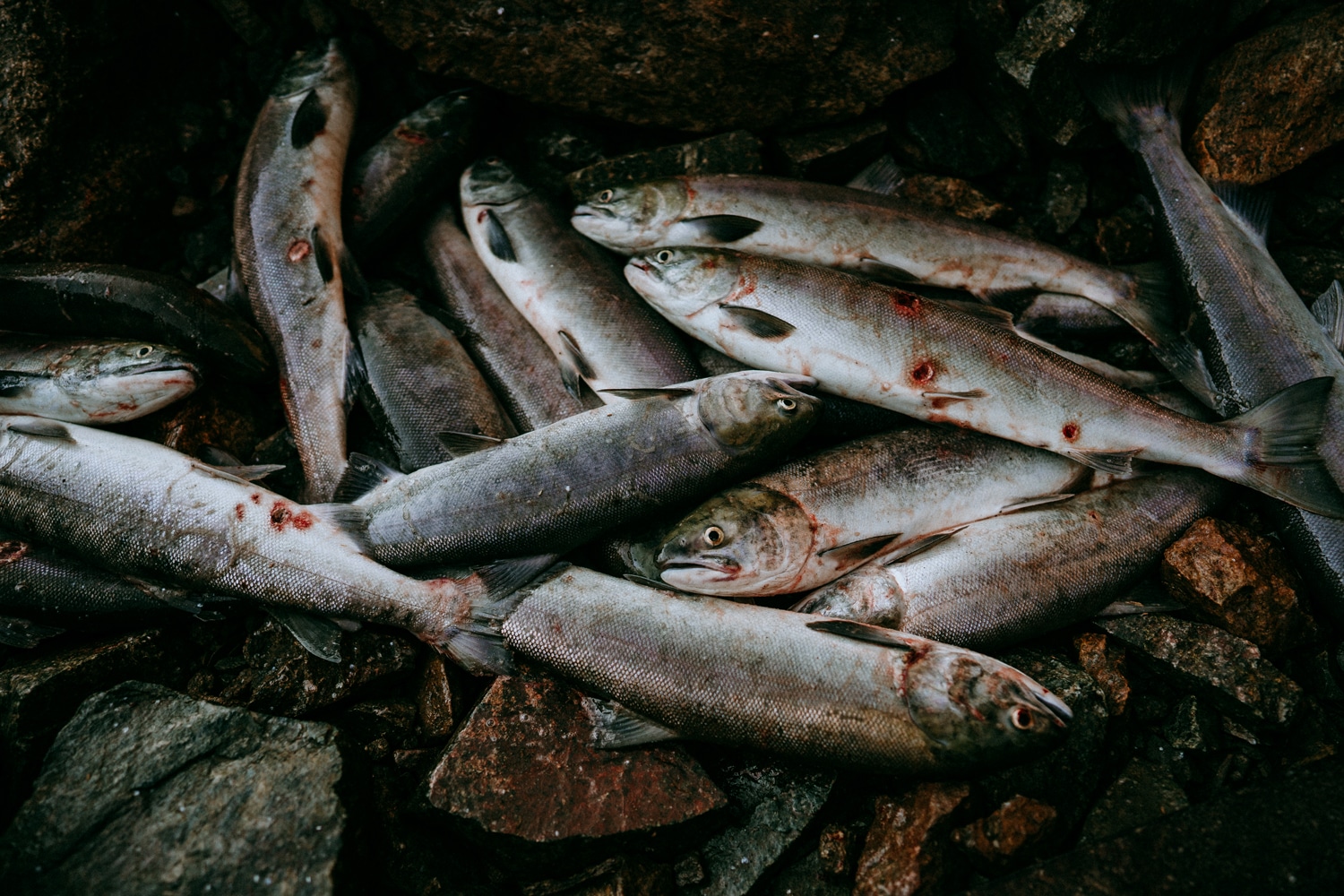
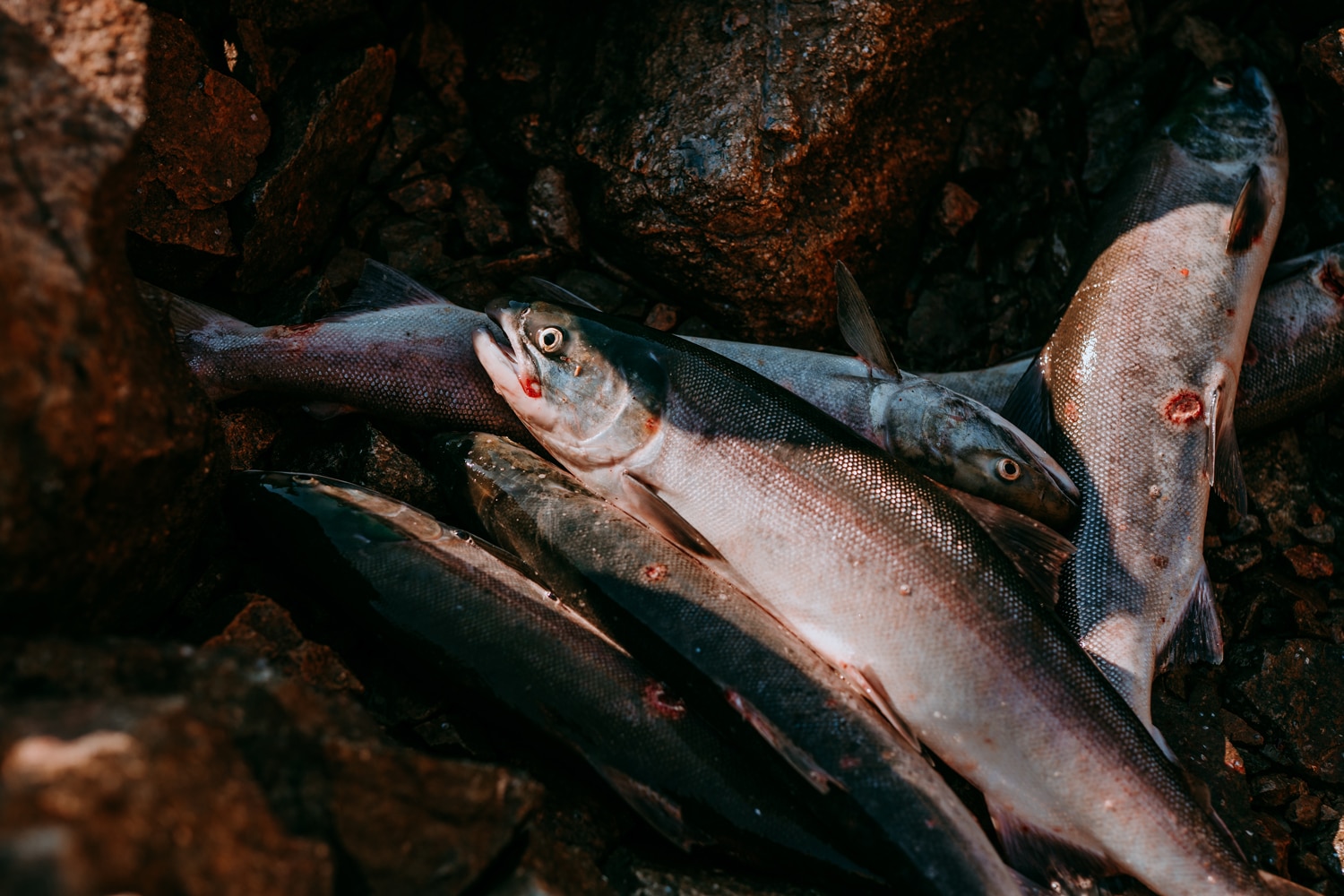
I know Farwell Canyon is the best fishing spot, because running my net off the calm back eddies where salmon choose to swim, I caught dozens.
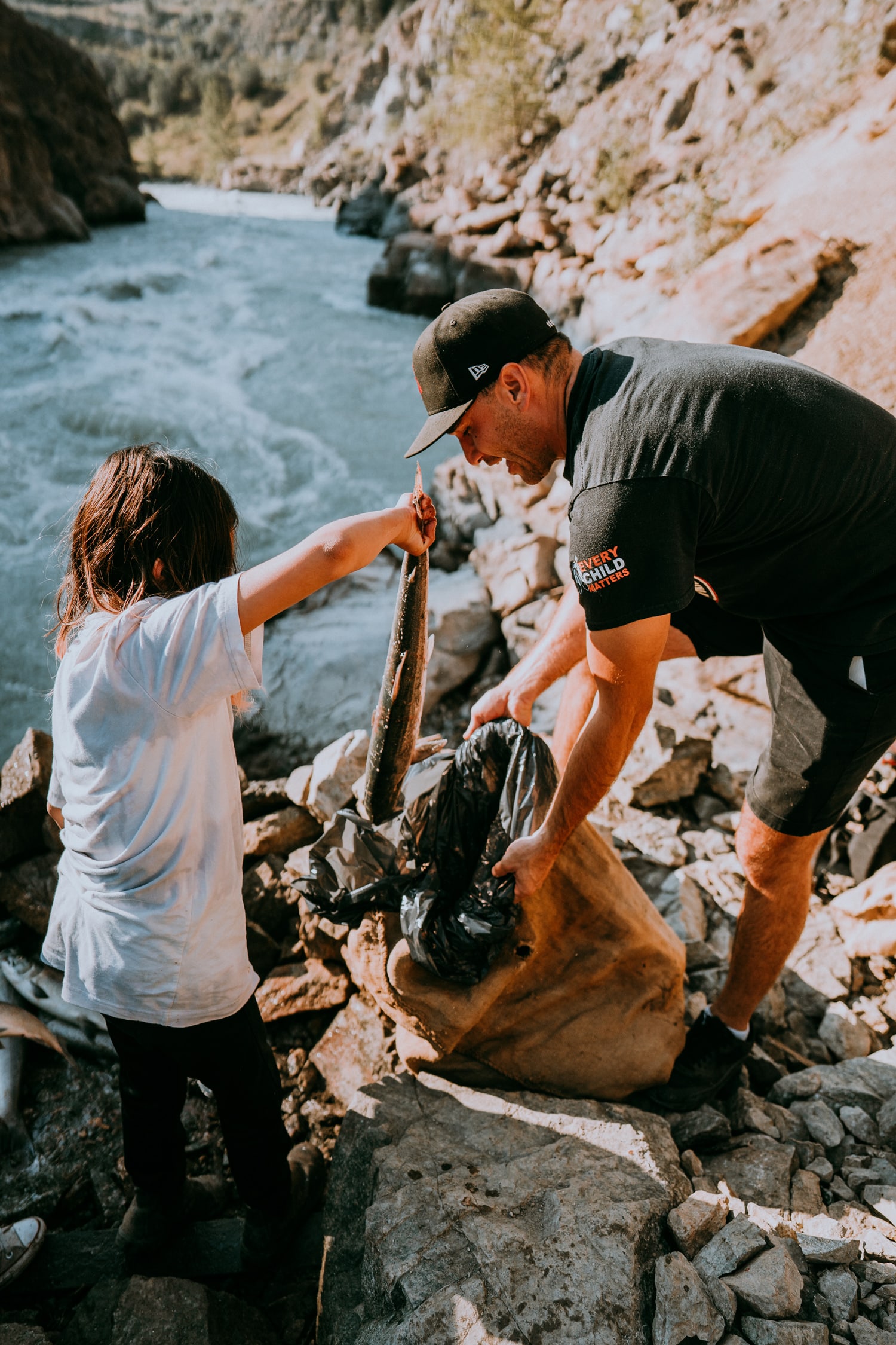
I know Farwell Canyon is the best fishing spot, because the first time I fished there it was just the third time I stuck a dipnet in a river in my entire life. Running my net along slimy rocks, through whirlpools, and off the calm ends of back eddies where salmon choose to swim because they need breaks and prefer the path of least resistance, I caught dozens. Alongside my friend Chief Willie Sellars of the Williams Lake First Nation, his dad Darrel, and Darrel’s buddy who lives in the cabin behind Darrel’s house on the SugarCane Indian Reserve, we must have hauled at least 100 sockeye and half a dozen chinooks out of Farwell Canyon that day. Maybe even more.
Audio Listen to the article, read by the author.
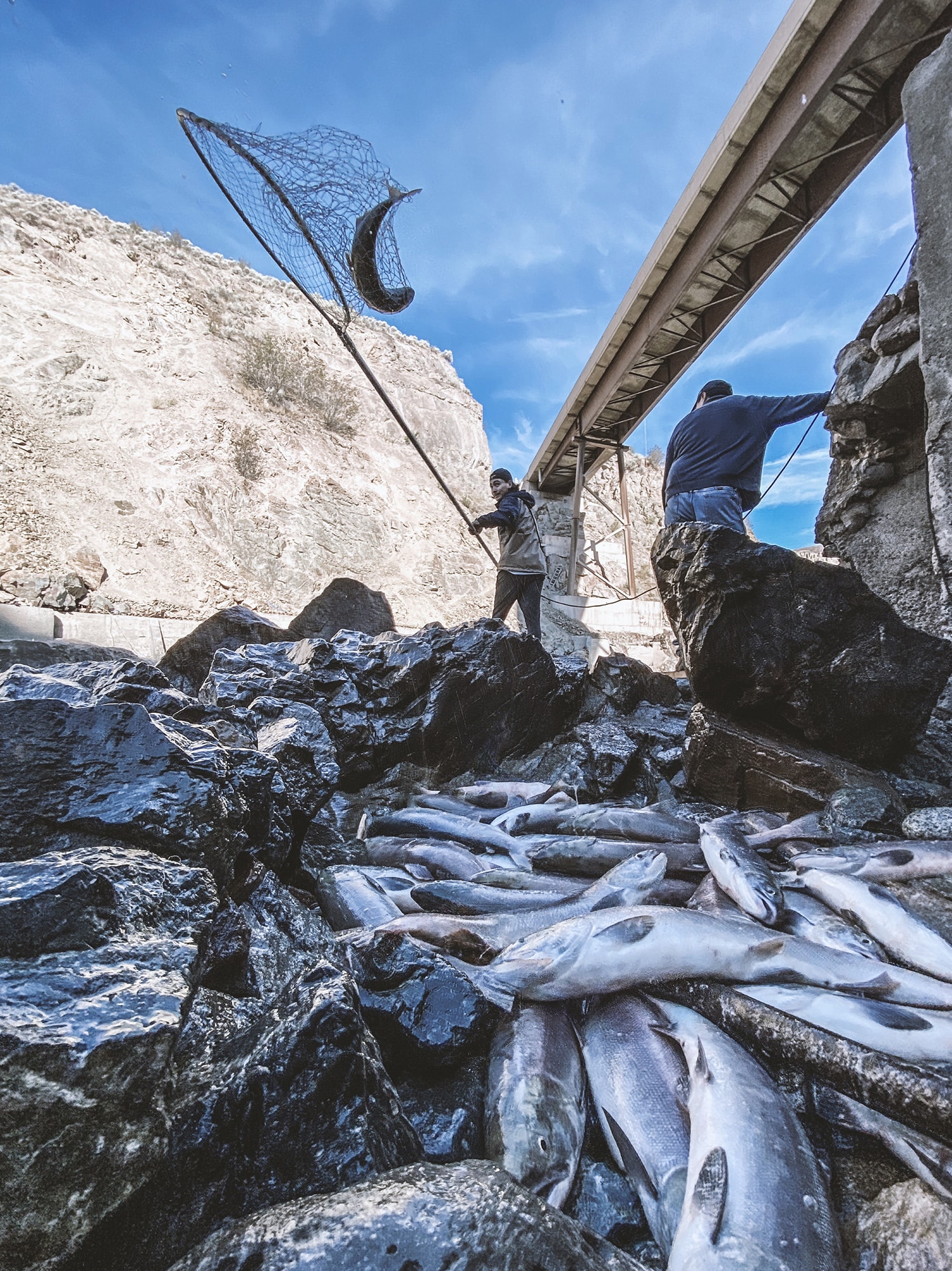
The hardest part? Getting those slimy swimmers into trash-bag-lined burlap sacks and hauling them up a canyon trail cut through sagebrush in sprints of 20 fish per trip, a weight of about 100 pounds. Then into the big ice chest in the back of the truck. The view from the top of the trail is breathtaking. Dune-drifted badlands punctuated by pinnacles that tower over our pale blue river like a great natural cathedral. With one of my burlap sacks emptied of fish but still full of slime, I pause to take in the beauty of Farwell Canyon, of our way of life, of Creation.
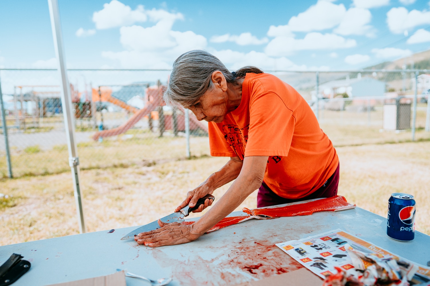
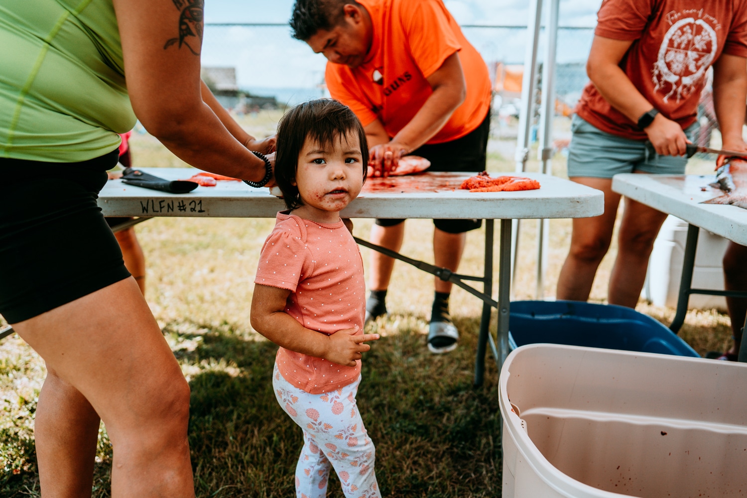
That afternoon, Willie, Darrel, Darrel’s buddy, and I rolled through the Williams Lake First Nation handing out fish. A dozen salmon into this smoke house, a dozen into the next, another dozen for drying, a dozen for a freezer here, another dozen over there. Fillets, fish eggs, fish heads, red fish, oily fish, fish appreciated. I don’t know how many people we fed. But it must have been hundreds. One fish makes at least half a dozen generous portions. Many more, if it’s one of those chinooks real fishermen call “hogs,” because king salmon are known to rival the heft of a pig. I’ve seen photographic evidence. Real fishermen love photographic evidence.
Fillets, fish eggs, fish heads, red fish, oily fish, fish appreciated. We must have fed hundreds.
Every Indian fisherman I know swears that, way back in the day, before the downriver canneries, industrial fisheries, and salmon hatcheries, all the fish were that big, and so plentiful a fisherman could walk bank-to-bank on their backs, like some sort of Indian Jesus, or that trickster Coyote. This was before the Pacific trawling fleets that lay out miles upon miles of net like area-code-sized dipnets to catch Alaska pollock for McDonald’s Filet-O-Fish, accidentally swiping river-runs-worth of salmon out of the ocean in the process. What the industry calls “bycatch.” That actually happened to the Chilko sockeye in 2019, when Alaska fishermen harvested 45,000 individuals set to return to our river, fully 20 percent of our run. That same year — while First Nations on the Fraser River could not fish because of a moratorium placed on the Indigenous fishery by Fisheries and Oceans Canada — Alaska fishermen caught 78,000 sockeyes bound for that river.
Before Indians lost so many of our lands, our ways, and our fish, Farwell Canyon was so plentiful that there were sedentary villages full of Secwépemc fishermen intermarried with a good number of Tsilhqot’in who fished the river year-round. Who used their surplus of fish to trade and to support a sophisticated clan system led by hereditary chiefs who threw feasts where they entertained their guests with special songs, elaborate masks, and theatrical dances. But that’s all gone now. The fish have dwindled, as have the Indians.
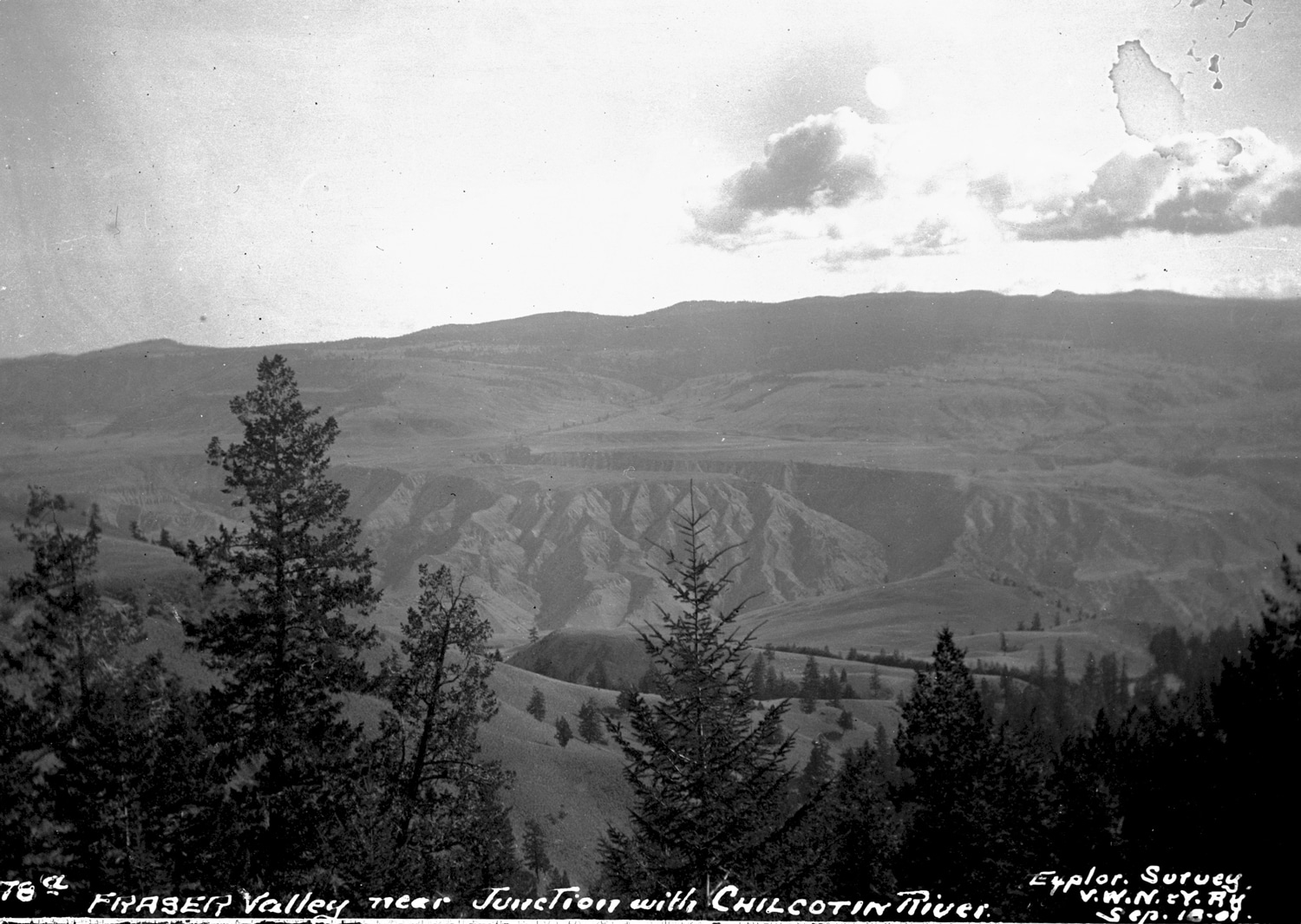
Farwell Canyon is a source of the most ancient form of Indian wealth: food. Farwell Canyon is a place where the abundance of our land is honored and redistributed. Chilko sockeye begin their lives in Chilko Lake. After maturing there, the fish swim northeast down the Chilko River, then southeast down the Chilcotin River to the Fraser, which makes a sharp bend west at a town called Hope, past Vancouver, then out into the Salish Sea, up the Pacific Coast several hundred more miles to the Gulf of Alaska, where Fraser River sockeye mature. Four years later, give or take, by some magic scientists still don’t fully understand, sockeye make the return journey. Back down the Pacific Coast past dozens of other rivers that other sockeye have colonized, but that these Chilko sockeye seem to take no interest in — sockeye are nothing if not loyal to their home river.
When the Chilko sockeye reach Vancouver, they school up and begin the long, exhausting ascent of the Fraser River. They’re stronger and fattier than the average sockeye, because they must travel up hundreds of miles of rushing river — a journey so difficult that no human has ever made the same upriver trip by boat. Along the way, the fish must dodge the nets of Indians like Chief Willie, Darrel, and me at Farwell Canyon and elsewhere, so that the fish can procreate, die, and return their corpses and the nutrients they contain to the lake and creek beds where they were born. Or they end up in the net and belly of a grateful Native like me. Another Secwépemc, another Tsilhqot’in, another loved one, tied to Farwell Canyon by blood, rights, tradition, and a safety rope, fed by the river and the people who have always fished it, us.
Farwell Canyon is a place where the abundance of our land is honored and redistributed.
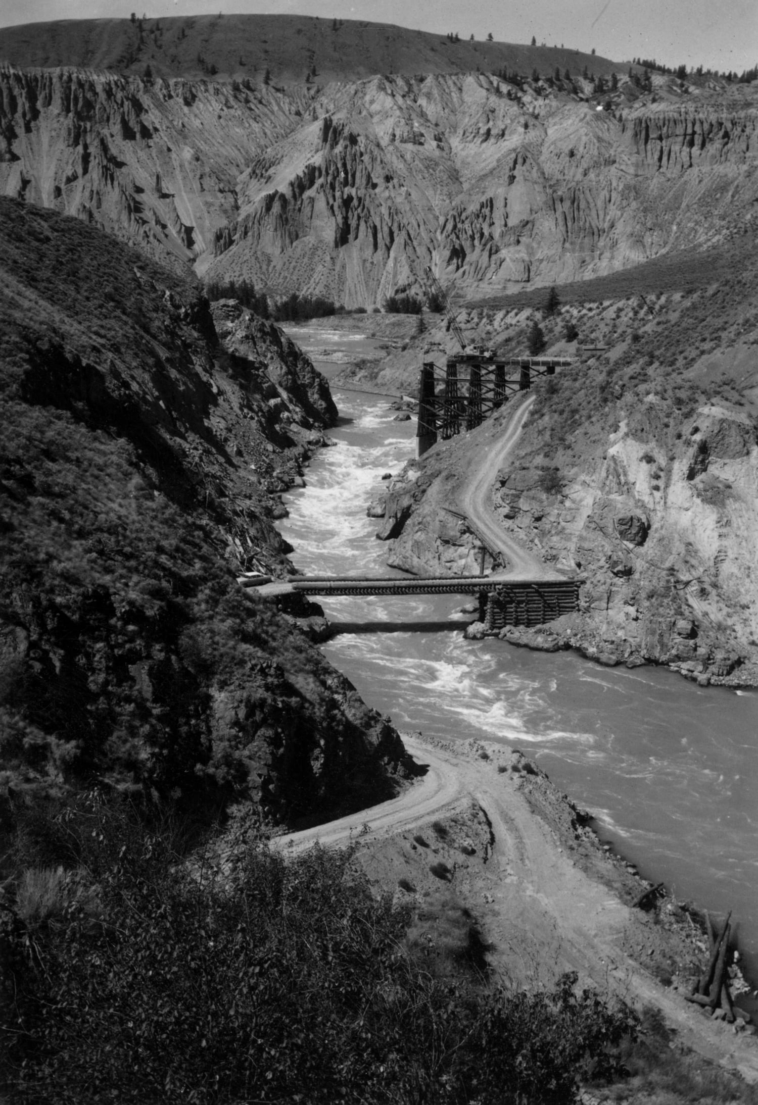
I have inherited three generations of fishing stories from Farwell Canyon. The oldest come from my pé7e (grandfather) Ray Peters. Back then, Pé7e used to throw the boys — sons, nephews, drinking buddies — in the truck and drive two-and-a-half hours from our Indian reserve in Canim Lake to Farwell Canyon. At Farwell, there’s a bridge across the Chilcotin River. In the wee hours, Pé7e would approach the bridge but would not cross, parking on the road above the east side of the river before descending with the men and boys to the rushing Chilcotin. There, they would slay fish until they had enough. One time, one of the guys, Chris, a Tsilhqot’in who married into Canim Lake, spotted a moose climbing those sage hills that extend a few hundred feet up the riverbank. Chris fetched a hunting rifle, and just as the moose was cresting the trail, he fired. The giant went hoof over antler down the hill into the river, where it was whisked away. I imagine it didn’t come out of the water for almost 100 miles, until it reached the flats near Lillooet. The same place where the bodies of fishermen usually show up when they fall in the river and drown.
Another time, Pé7e and his buddy Willie Frank were sitting in that same truck, probably having a few beers, when they saw a UFO zip down from outer space and hover right there in the canyon. True story, at least that’s what I’ve heard. And it’s not implausible to me. Indians have been gathering on this stretch for as long as there has been a river teeming with fish here. Why wouldn’t extraterrestrials, if there are such things, join us at our gathering place?
In August of 2015, Pé7e’s brother-in-law, my uncle Percy, was on his deathbed in the Cariboo Memorial Hospital in nearby Williams Lake. My dad and I went down to Farwell Canyon and sat alongside the Chilcotin River between hospital visits. Across the river, on the west bank, we watched a Tsilhqot’in run his net for at least an hour before he caught and clubbed a sockeye. It was a poor run that year, in part because of the large mass of warm water in the Pacific known as “The Blob,” and in part because of an earlier-than-usual spring melt. I guess that’s what climate change looks like to a Secwépemc: a Tsilhqot’in on the opposite bank of the river that runs between our nations, getting skunked.
I guess that’s what climate change looks like to a Secwépemc: a Tsilhqot’in on the opposite bank of the river, getting skunked.
See, all my Farwell Canyon stories come from the east side of the Chilcotin River. And even if some of these events didn’t happen on the east side, I always imagine them that way. Because the east side of the Chilcotin is the Secwépemc side. The side I always approach from. The side my nation fishes. The west side — the far side when you’re approaching from Secwepemcúl’ecw, Secwépemc territory — is Tsilhqot’in country. It’s the side of the river where they park their trucks and descend a treacherous trail to the water, almost mirror images of us, but not quite.
Farwell Canyon isn’t just a productive river fishery. It’s a contested one. Where my nation, the Secwépemc, and our ancestral enemies, the Tsilhqot’in, the “People of the Red River” after whom the Chilcotin River is named, both fish. Looking across the river at each other with envy and suspicion, comparing catches. Each insisting that our fishing and fish-processing techniques are superior. Each steadfast in our belief that this is our territory. Each with a legitimate claim to it.
Let’s go back to the origin of this conflict. Let’s go back to Creation. See, a long time ago, there were no salmon in the Chilcotin River. The ascent at Farwell Canyon was simply too steep for sockeye and chinook. That is, until the trickster Coyote came around. Which is when the Secwépemc begin the story.
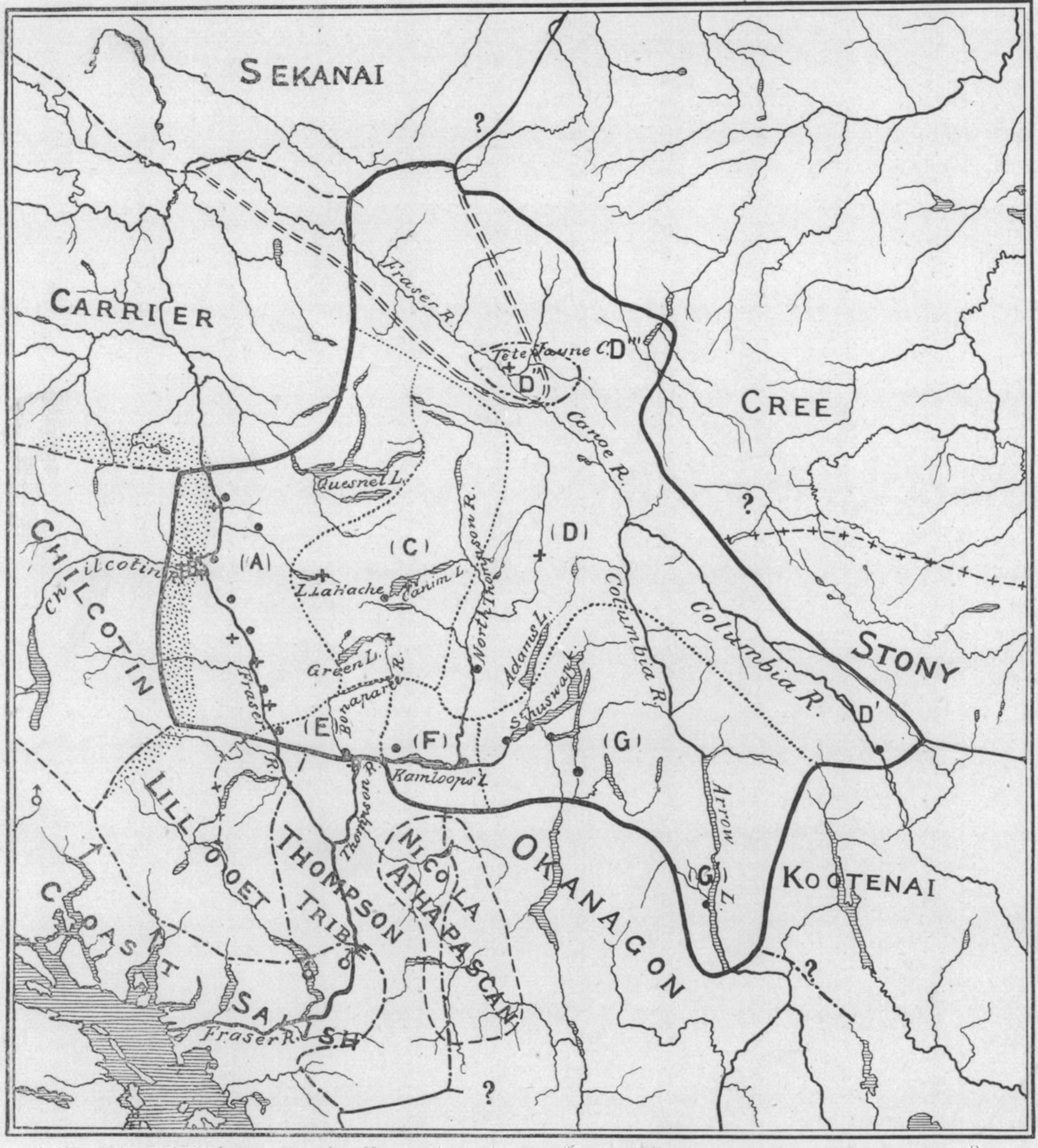
Before salmon ascended the Chilcotin, Chilko, Fraser, Thompson, and Columbia Rivers into the interior, where the Secwépemc and all our Interior Salish cultural cousins live, we say, the fish were hoarded by greedy witches who lived at the mouth of these rivers, keeping all the fish for themselves. In a Secwépemc version of this Coyote Story told across the plateaus of the northwest (border be damned), the witches operated a weir, a large fish trap, just upriver of Spences Bridge on the Thompson River. The place where our histories say the witches’ weir stood is the same spot where geologists tell us that, at the end of the last Ice Age, there stood a great ice dam that held up a series of glacial lakes covering much of the interior: Glacial Lake Thompson, Glacial Lake Deadman, Glacial Lake Fraser.
Let’s go back to the origin of this conflict, back to Creation. The ascent at Farwell Canyon was simply too steep for sockeye and chinook.
Around that time, Coyote got caught in the weir that is our metaphor for an ice dam. Through a series of tricks, Coyote transformed himself. Some say into a canoe, others say a feast platter, still others say a scrap of driftwood. Through this supernatural camouflage, Coyote made his way inside the witches’ home. There, disguised, Coyote feasted on the witches’ endless supply of salmon. Until Coyote’s gluttony revealed him. In my favorite version of the tale, Coyote transforms himself into a feast dish. His bony ribs cutting a design around his hollow belly, which formed a bowl. His nuts in the air. The witches used Coyote to store their salmon, and the trickster ate their fish. After days of engorging himself, Coyote’s ribs and belly filled in. The bowl was barely a bowl anymore. The witches discovered the trickster’s identity and tossed him into their hearth. (Coyote is always catching his tail on fire, that’s why it’s singed black.) But Coyote did not die. He never does.
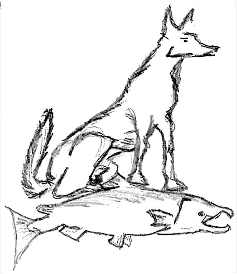
Instead, Coyote transformed into as pitiable a form of himself as he could, and convinced the witches to keep him. In some versions of the tale, it’s Coyote as pet, in others, as adopted child, and still others, as slave. Not long after, Coyote hatched a plan to breach the witches’ fish trap and lead the salmon upriver. Our people believe that our culture and way of life were stolen by our trickster forefather from supernatural antagonists who were doing something obviously morally wrong: catching and keeping all the fish for themselves. Fish are supposed to be shared.
As it so happened, about 11,000 years ago, that ice dam broke, sending a wall of water gushing down to carve out what is now Fraser River Canyon. This ancient jökulhlaup drained the glacial lakes above, reversing the course of the Thompson River, which had, until then, flowed eastward into the Columbia. Ever since, the Thompson has flowed west, its clear blue waters meeting the silty Fraser at present-day Lytton, not far south of Spences Bridge. Evidence of this great flood can be found in the mud it sent shooting all the way across the Georgia Straight to Vancouver Island, where alluvial deposits from this time are flecked with pollen from the interior.
The DNA of coho salmon populations — which show two distinct subgroups, one below Fraser River Canyon, and another above it — offer further evidence of Coyote’s dam-breaking mischief. In fact, signs of Coyote’s ancient smash-and-grab are all around. Just look at the banks of the Fraser, Thompson, Columbia, and Chilcotin, and imagine the might and height of the water that cut such immense canyons into the land. Farwell Canyon, with its loose, silty badlands stretching hundreds of feet down to the Chilcotin is an especially unstable spot in a riverine landscape that has been steadily transforming for over 10,000 years.
Coyote hatched a plan to breach the witches’ fish trap and lead the salmon upriver. Fish are supposed to be shared.
Back to Coyote. After breaking that fish-trap dam, Coyote led the salmon up the river. I like to imagine him riding on the fishes’ backs, like the devilish silver surfer he is. Coyote stopped at every riverside village along the way, offering the villagers fish — if they let him marry into their community. Most accepted. When they did, Coyote created fishing spots for them. The Esk’etemc, Secwépemc people from Alkali Lake who live on the Indian reserve closest to Farwell Canyon, still pass down the name Kellalst, the name of one of Coyote’s sons. Down on the Colville Reservation in Washington state, the confederated Colville tribes tell this same Coyote Story from the perspective of the women and families who did not marry Coyote but still benefited from his fish — the best of both worlds, no doubt. The Ktunaxa and all the Sahaptin tribes, who are not Salish, also tell versions of this Coyote Story.
Because there is truth in this ancient tale. Not only does it show the responsibility of each community to every other on the river through the counterexample of the witches. It also shows the origin of our rights to the river’s salmon, since it was our trickster ancestor who stole and gifted them to us, his in-laws and descendants. The tale mirrors historical migrations. Archaeological, cultural, and linguistic evidence indicates that about 5,000 years ago our Salish-speaking ancestors, who originally lived in the Fraser River delta around present-day Vancouver, began migrating upriver (like Coyote before them), bringing their salmon-fishing culture with them. In the interior, these Salish speakers coexisted with other nomadic peoples. The very name of the Secwépemc, my people, the northernmost Interior Salish nation, acknowledges this truth, as Secwépemc literally means “Spread-out People.”
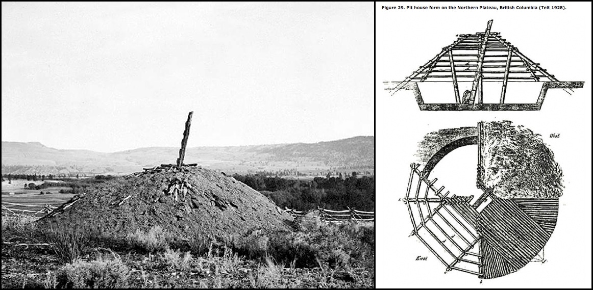
Eventually, speakers of Salish languages spread into and cared for territories from Vancouver northeast, past present-day Williams Lake, west to Bella Coola, south to the Columbia River, and east to the Bitterroot Mountains. Archaeologists can tell this, because all Interior Salish people built the same style of winter home: a pit house, a round and often large structure dug into the earth where our people would ride out the cold months warmed by the fire and one another’s bodies. The pit house is where we would tell many of our stories, like the ones about Coyote, which were the most ubiquitous and popular. 1
Our Salish-speaking ancestors began migrating upriver (like Coyote before them), bringing their salmon-fishing culture.
According to the stories, one of the last places Coyote visited was Farwell Canyon — because, over time, erosion transformed the river and the canyon into a waterway that salmon could ascend. The ethnographer James Teit says this happened not long before the arrival of settlers, maybe the 1820s or ’30s. A more recent airborne LiDAR study conducted by the Williams Lake First Nation found extensive evidence of Secwépemc settlement in Farwell Canyon stretching back some 4,000 years. “These pit houses are older than the pyramids!” exclaimed the Director of Natural Resources for Williams Lake First Nation, Whitney Spearing, in a statement announcing the findings. 2 It is possible, however, that both Teit and the Williams Lake First Nation are correct. The Secwépemc may well have lived near Farwell Canyon for thousands of years, given the antiquity of Salish migration into the interior. It is also possible that changes in the topography of the canyon, which is prone to landslides, may have made the area uninhabitable and less productive as a fishery for certain periods of time. So, before the 1830s, it may well have been the Secwépemc who were, in a sense, the witches — since the falls that once shot through Farwell Canyon prevented our upriver rivals, the Tsilhqot’in, from fishing the Chilcotin River.
In any case, by the mid-1800s, the east side of the Chilcotin was home to a big branch of the Secwépemc nation. These canyon Secwépemc, called Sétlemc or “People of the Canyon” in our language, built a bridge across the river to facilitate trade between the people of the interior and those of the coast, especially the Tsilhqot’in. With all those fish, the canyon Secwepemc became wealthy. They developed a stratified society based on a clan system akin to those of the Northwest Coast.
It is worth pointing out, however, that this was a society oriented around the natural wealth of river and land, rather than the fur trade or some other imperial game controlled by White men. According to Teit, Secwépemc families along the Chilcotin would carve their clan crests onto the tops of the ladders leading down into their pit houses. They would host large feasts where they would sing and dance, donning carved masks representing their animistic and mythic lineages. The elites among them were granted the power to manage the relationship to salmon, the right to host a feast, and the prestige of other ceremonial privileges because they held up their side of the social compact: redistribution. This was a society rooted in reciprocity, wherein chiefs who feasted and gave gifts to neighbors could expect the favor would eventually be returned. In 1850, these Secwépemc with their bellies full of salmon were living in four villages: one at the north end of the Chilcotin, one towards the south, one at the mouth (Farwell Canyon), and a fourth at Riske Creek, a territory of roughly 500 square miles populated by about 700 people.
The east side of the Chilcotin River was home to the Secwépemc nation, who built a bridge to facilitate trade with the Tsilhqot’in.
After several decades of peace and prosperity, in the winter of 1862-63, smallpox broke out across the northwest. It originated on a ship from San Francisco that landed in Victoria. From there, the pathogen spread quickly in the Indigenous shantytowns that had sprung up around the colonial city where Natives arrived from far and wide to trade. Colonial authorities panicked, vaccinating settlers while ordering Indigenous peoples to disperse, even though they knew such a directive would serve to further circulate the deadly disease in a vulnerable, non-immunized population. Local papers encouraged this course of action. It’s almost like the colonizers wanted us to die. About 20,000 British Columbia Natives perished in that epidemic, according to historian Robert Boyd, representing nearly two-thirds of a population already cut down by prior waves of disease. The infection traveled inland from Bella Coola, reaching the Tsilhqot’in on the Chilcotin Plateau and the Secwépemc on the Chilcotin River.
Teit, the ethnographer, estimates that more than two-thirds of the Secwépemc died. The Sétlemc, or canyon Secwépemc, who lived on the Chilcotin year-round, eating and trading fish, were wiped out entirely; their prosperous, sedentary way of life became, with the introduction of smallpox, a death sentence. A few survivors made their way east and settled among the Secwépemc of the Esk’et and SugarCane Reserves. A few others moved in with their Tsilhqot’in relatives. 3
In summertime, year after year, our people had gathered in the same spots to visit, play games, compete in sports, trade, and hook up. But in the summer of 1863, entire villages were missing from these celebrations. When their neighbors and relatives went to check on them, they found pit houses full of corpses. I once heard a story about a little girl who was the lone survivor in her pit house. She walked to Esk’et, where her descendants live to this day.
Enter the Athabascans, an ethnolinguistic group that includes the Tsilhqot’in. Their backstory is extensive, and it will carry us all the way from Siberia to Mexico. But bear with me. Because the Athabascan migration — which brought the Tsilhqot’in to Farwell Canyon — is one of the most important North American histories never told.
The story begins in the winter of 852 or 853, when a volcano in present-day Alaska, now known as Mount Churchill, erupted like Vesuvius over Pompeii, spewing ash so far into the atmosphere that some drifted all the way to northern Europe. It was like a gun went off and the most consequential Indigenous migration in North American history commenced. Because Creator is a theatrical guy.
The Athabascan migration, which brought the Tsilhqot’in to Farwell Canyon, is one of the most important North American histories never told.
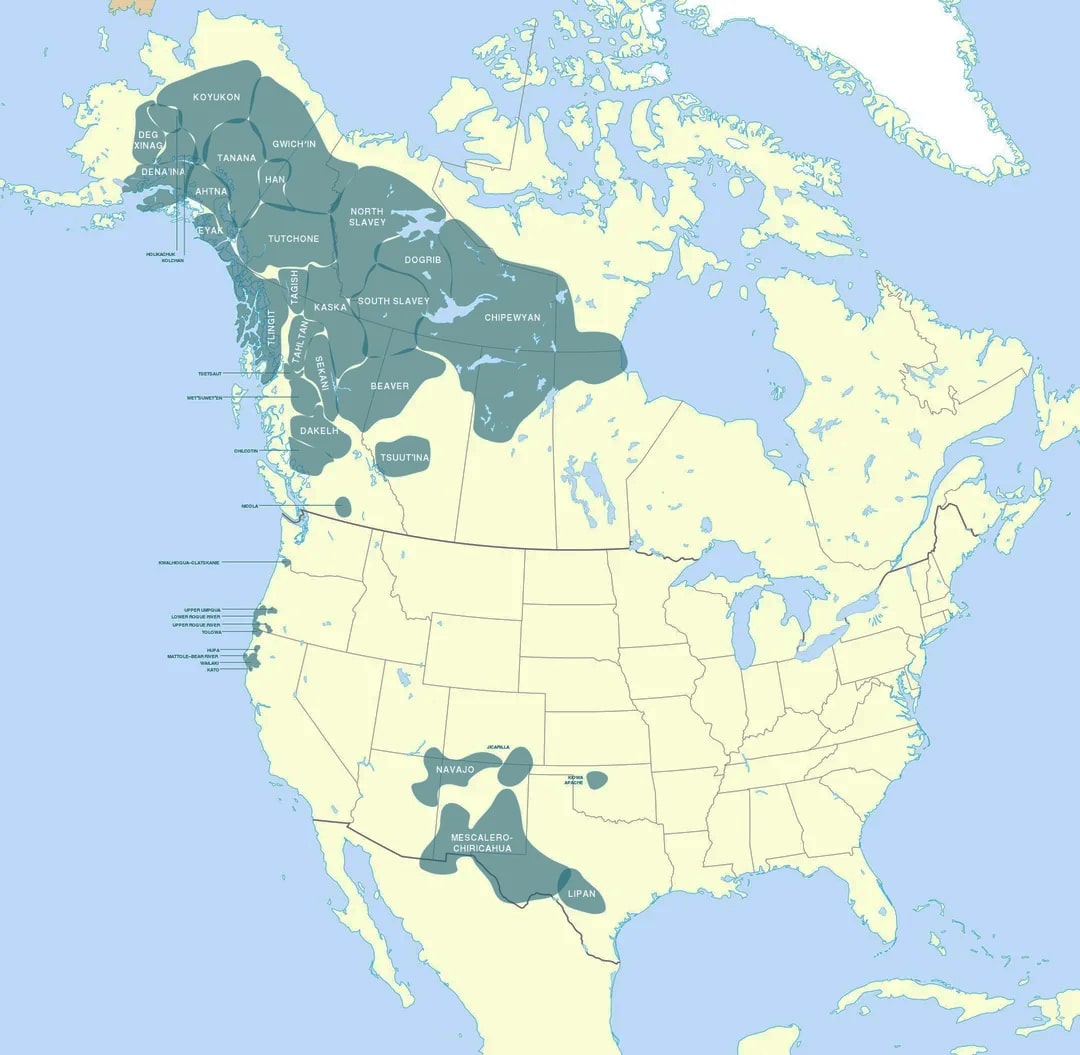
Exact motivations for the Athabascan migration remain uncertain. One theory, the most popular, is that the eruption of Mount Churchill rained death down on the caribou herds, necessitating an immediate exodus of the Athabascans who hunted them. Other researchers have pointed out that the Athabascan exodus roughly coincides with the arrival of the ancestors of the Inuit. The Inuit, who were enemies of Athabascan peoples like the Gwich’in, showed up armed with a culture well-adapted to Arctic life. Following the bowhead whale and other sea mammals east, the ancestral Inuit quickly spread from Alaska all the way to Greenland. On the way, they bumped into and skirmished with the Athabascans. But that’s probably just part of the story. Another part appears to be that the Athabascans themselves were changing their ways around the time of the Mount Churchill eruption. They had put down the atlatl and picked up the bow and arrow, as had many other people across North America. Perhaps relatedly, their numbers appear to have been growing. At any rate, the metaphoric starting pistol that went off when Churchill erupted resounds to this day across the continent, from the Navajo and Apache in the southwest, to the Hoopa in California, to the Tsuut’ina in Alberta, the Gwich’in in the Arctic Circle, and, of course, those Tsilhqot’in across the river from us in Farwell Canyon. They are all Athabascans.
Everywhere they went, the Athabascans exhibited seemingly paradoxical characteristics: simultaneously immutable and adaptable, defiant yet chameleon-like. To this day, Athabascan languages spoken in northwestern Canada and the southwestern United States are more closely related than Salish languages spoken, in some instances, one valley or inlet away from one another. “It has often been said that Athabaskan languages are exceptionally conservative, spreading their influence wherever they have come in contact with other languages but not being affected much in turn by them (although their speakers have been highly adaptable culturally)” writes Michael Fortescue in Language Relations across the Bering Strait. “The family is certainly highly distinctive and more homogenous than, say, Salishan.” 4
In fact, Athabascan tongues are so slow to change that they are the only language family with a proven relationship to languages spoken on the opposite side of the Bering Strait, by people like the Ket of Siberia. Despite the many adaptations Athabascans made to the very different parts of the continent where they settled, they told stories about sacred mountains wherever they went. And, always, they were tough. They held their own in fights. The Secwépemc will tell you that the Tsilhqot’in still do. At the same time, Athabascans absorb the cultures and customs of their neighbors. That’s why Athabascans can be found doing all sorts of things across the continent: herding sheep like the Navajo, catching lampreys like the Hoopa, eating buffalo like the Tsuut’ina, shooting caribou like the Gwich’in, and netting salmon like the Tsilhqot’in.
Navajo in the southwest, Hoopa in California, Gwich’in in the Arctic Circle, Tsilhqot’in in Farwell Canyon: all Athabascans.
Athabascans are often depicted as the archetypal Indigenous Americans. How many stories have been told about Apache guerilla warriors like Geronimo? And how many films were shot in Monument Valley on the Navajo Nation? The Navajo Nation is the largest tribe in the United States, numbering 400,000 members. They also have the largest number of speakers, with 170,000 people still using the language. They have one of the few Indian reservations in North America that has grown substantially over the last century. As my Navajo friends like to joke, Navajos are like Starbucks: there’s one in every town. Athabascans, then, are both the posterchildren for Indigeneity and North America’s most successful and significant precolonial migrants. You cannot understand what has been going on in the western half of this continent for the last 1,000 years without grappling with the long and fast journeys Athabascans made from the far reaches of northwestern North America, where they started, across the tundra and down the Great Plains, Rocky Mountains, and Pacific Coast.
The Secwépemc, and our Interior Salish neighbors the Nlaka’pamux and Syilx, remember one of the last waves of this migration in our oral history. Not long before the arrival of the Whites, a group of Athabascan-speaking people, the Stuwix, whose name means “strangers” in Nlaka’pamux, followed the Bonaparte River south to the Thompson River Canyon, and on into the Nicola Valley. We chased these Athabascan strangers, and there was a big fight. All the Athabascan men were killed. The Athabascan women, whom we found fierce and beautiful, married into the Nlaka’pamux of the Nicola Valley. When James Teit showed up there at the turn of the 20th century, he found a few surviving Stuwix who could still speak their Athabascan language. But those survivors refused to speak it for him. He was, after all, the ethnographer.
The Stuwix’s relatives to the north, the Tsilhqot’in and Dakelh, fared much better. These Athabascan-speakers arrived at Anahim Lake by about 1300, according to R.G. Matson and Martin Magne, authors of Athapaskan Migrations: The Archaeology of Eagle Lake. 5 The archeologists can tell because, unlike Salish pit houses, Athabascan winter lodges are long and rectangular, with each village containing just one or two structures where everyone lived during the cold months. Athabascan arrowheads are thinner, more elongated, with small side notches, while the Salish flaked obsidian into equilateral points with deep side notches. At Anahim, the Ulkatcho — a mixed Athabascan nation of Tsilhqot’in and Dakelh — came into possession of one of only two obsidian sources in what is now British Columbia: Anahim Peak, a mountain they call Besbut’a.
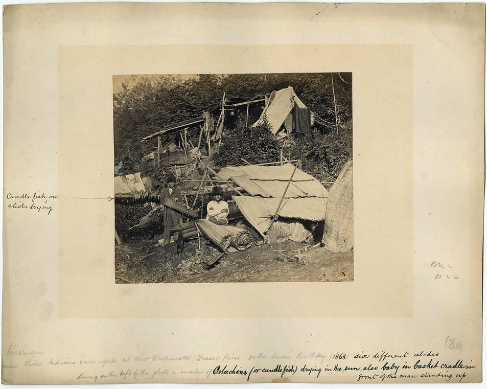
With a huge supply of essential materials for tools and weapons, the Dakelh muscled their way into a central role in the trading corridors that ran from coast to interior. More nomadic than the Salish, they traveled frequently to trade obsidian for grease derived from eulachon, or candlefish — a nutrient-rich oil with a high smoke point used for food, cooking, medicine, and occasionally as bait. The English name for the Dakelh, “Carrier,” refers to the prominent role these Athabascans played in the regional economy, carrying their products along the “grease trails” lined with obsidian flakes that connected coastal peoples like the Salish-speaking Nuxalk in Bella Coola to the Salish-speaking Secwépemc in the interior.
On his journey to the Pacific in 1793, Sir Alexander Mackenzie followed these grease trails, which he described as a “Great Road” across the Chilcotin Plateau to Bella Coola, becoming the first White man to cross the continent north of Mexico. On the trail, Mackenzie noticed a Dakelh girl wearing two halfpennies for earrings. One was from Britain, the other from the Massachusetts Bay Colony, which had just fought the British for independence. The fact that those coins traveled the continent before any European did is evidence of the interconnectedness of the Indigenous world, and the prominent role Athabascans played in making such connections prior to colonization.
All this is evidence of the interconnectedness of the Indigenous world, and the prominent role Athabascans played.
The Tsilhqot’in, a southern offshoot of the Dakelh, were also a trading nation. In Secwepemctsín, we call them Pesxíxnemc, which means “Dentalium People.” The Tsilhqot’in, like the Dakelh, were traders who traveled from the coast to the interior, where they supplied our people with dentalium shells (for jewelry), as well as obsidian, eulachon grease, and other goods. According to Matson and Magne, they arrived in what is now Eagle Lake, British Columbia, around 1650. As they moved south into areas formerly occupied by Salish pit-house builders, the Tsilhqot’in earned a fierce reputation. When the fur trader and explorer Simon Fraser descended what would become known as the Fraser River in 1808, he encountered a few Tsilhqot’in on the western banks, whom he described as having a “roguish” disposition. 6 The friendly Secwépemc, by contrast, sent one of our chiefs, a man named Cllecwúsem, to ride ahead of Fraser to make sure our downriver relatives knew the White man was coming and would take care of him. This was likely because the Secwépemc wanted Fraser and the fur traders to set up a fort in our territory, to supply and empower us.
True to their reputation, the Tsilhqot’in response to colonization was far more defiant. The Hudson’s Bay Company set up a fort on the Chilcotin in 1831, but they found the Tsilhqot’in hostile to their presence. A Hudson’s Bay trading expedition onto the Chilcotin Plateau in 1831-32 was sent back after encountering “a very rough reception” with “menaces towards them,” according to fur traders’ journals. In 1836, the fort was closed for a year because the fur traders feared the “troublesome and disorderly” Tsilhqot’in. In 1838, a local Tsilhqot’in chief, Allaw, marched into the fort and announced that he had forbidden his people to hunt for the fur traders, adding that he expected the interlopers to “be off his lands immediately so that [the Tsilhqot’in] might have the pleasure of burning the Fort.”
The next year, the Tsilhqot’in built a fishing weir downriver, and attempted to starve out the Hudson’s Bay Company. The fur traders barricaded themselves into defensive positions. In 1841, an Indian hater named Donald McLean took over the post, which he described as “a dead loss to the HB Co and risking the lives of people placed at it — who are little better than slaves to the Indian, being unable to keep them in check.” In 1844, the Hudson’s Bay Company abandoned the fort.
But that was just the beginning of hostilities. Beginning in 1858, there was a series of gold strikes in the region now known as the Cariboo-Chilcotin. Thousands of miners poured into the area following long and sometimes dangerous roads hundreds of kilometers up the Lillooet and Fraser Rivers. In response, the politician and businessman Alfred Waddington advocated construction of a shorter route to the goldfields — from Bute Inlet on the Pacific Coast inland along the Tsilhqot’in’s Great Road. It was an idea he hatched after examining incomplete maps of the region. In 1861, Waddington sent a surveyor to scout the route. The man nearly died, turning around before making it halfway. Undaunted, Waddington received a charter from the Colony of British Columbia to build his road. Just ten days later, smallpox broke out in Victoria. The epidemic hit the interior around the same time as Waddington’s crew began blasting out their route from Bute Inlet. It killed about half of all Tsilhqot’in, and that’s a conservative estimate. Many who did not die of the virus starved the following winter, because they had been too sick to gather the food they needed during the warm months.
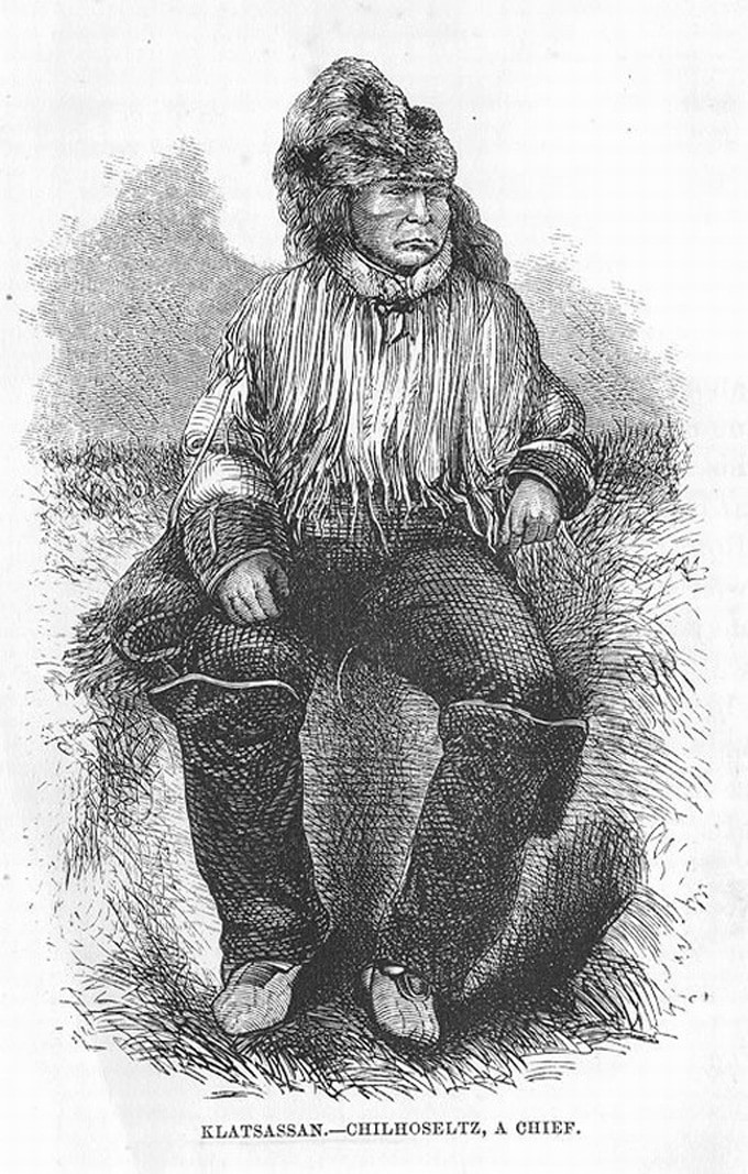
The epidemic fomented suspicion among the Tsilhqot’in, who were already wary of outsiders. In 1864, when the road builders returned for another season of construction, they found that the Tsilhqot’in in their employ had stolen and eaten the crew’s food cache. They called together their Tsilhqot’in workers. “A white man took all our names down in a book … & told us we sho[ul]d all die, whose names were there of small pox,” recalled the powerful Tsilhqot’in war leader, Klatsassin. The Tsilhqot’in, who believed in wicked spiritual powers just as the Secwépemc and other Indigenous peoples do, took the White man’s threat seriously. 7
These Athabascan-speaking roadbuilders had reason, after all, to hate Waddington’s crew. In their oral histories, they tell of being treated like slaves by the Whites. Their women, including Klatsassin’s own daughter, had been raped. So, on the night of either April 29 or 30, 1864, the Tsilhqot’in snuck into the workers’ tents and murdered fourteen of them. They cut open the foreman and, according to Tsilhqot’in accounts, ripped his heart out. Just like Magua, played by Wes Studi, ripped out Colonel Munro’s heart in Last of the Mohicans. Just three workers made it back to Bute Inlet.
Within a matter of weeks, the few settlers who had been brave enough to live among the Tsilhqot’in on the Chilcotin Plateau fled. The colony raised two settler militias to exact revenge, one from Fort Alexandria to the east and another from Victoria, both eventually under the command of British Columbia Governor Frederick Seymour. The party from Fort Alexandria was full of Americans who had nearly exterminated Natives in places like California, along with that Indian hater Donald McLean. In an early skirmish, McLean was singled out by the Tsilhqot’in and killed by a single bullet through the heart. The Tsilhqot’in played cat-and-mouse with the governor and his militia throughout the summer. The governor and his men considered returning home, even though such a course of action would, according to Seymour, “spread the notion throughout the Indians of the whole Colony that we had been beaten, and in point of fact, this was not far from being the case.” The governor wrote to his superiors in London saying that, if war continued to spread, he might “find [himself] compelled to follow in the foot-steps of the Governor of Colorado … and invite every white man to shoot every Indian he may meet.”
With the demise of the canyon Secwépemc on the Chilcotin River, Tsilhqot’in territory expanded.
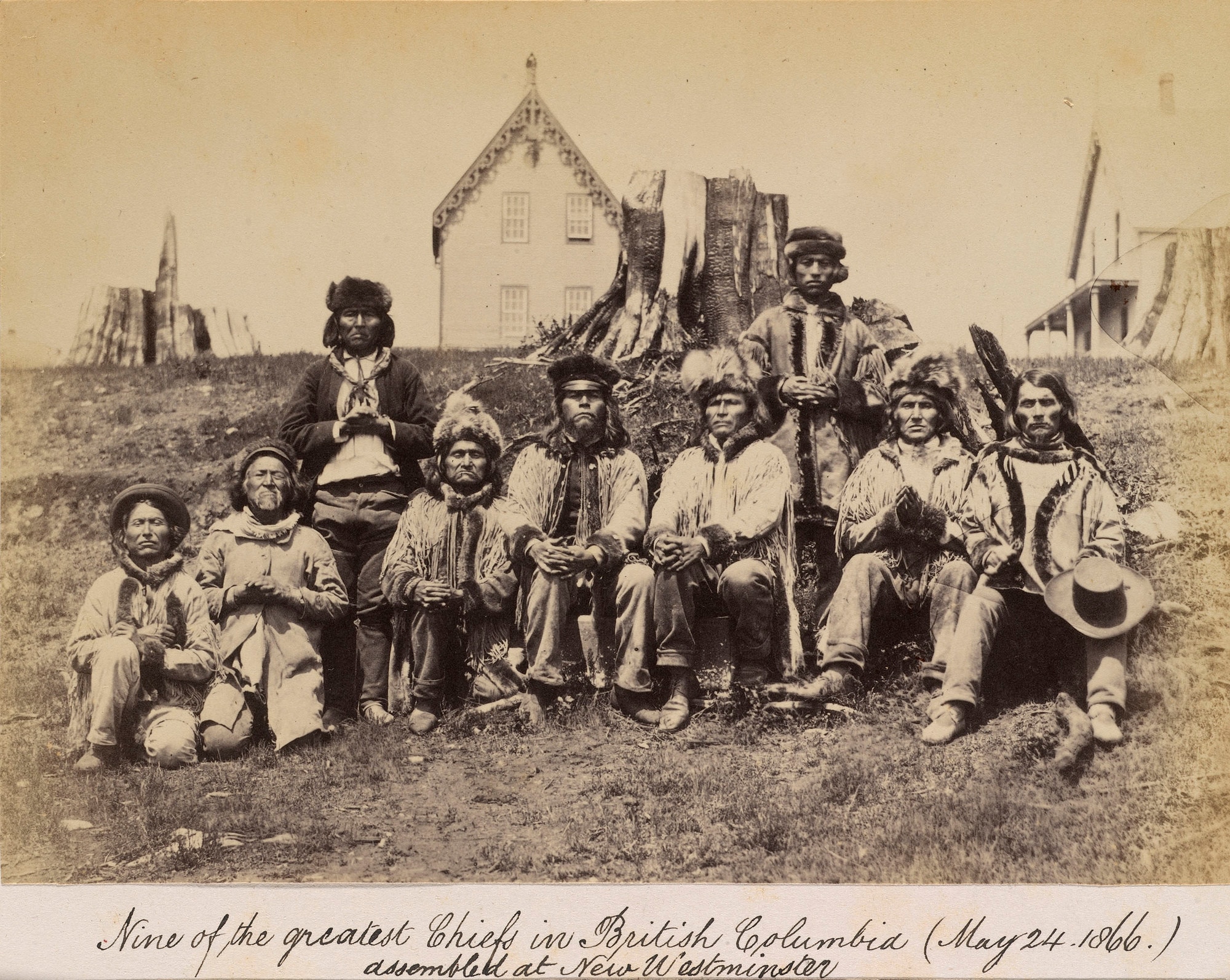
At the last minute, the Tsilhqot’in Chief Alexis, tired of the conflict, marched into the governor’s camp and inquired “with something approaching a sneer, how long [Governor Seymour] meant to remain.” With Chief Alexis’s help, Klatsassin, the war leader, was called to what Klatsassin believed was a truce negotiation, where he and seven members of his party would smoke the peace pipe and allow the Whites to withdraw. It’s unclear whether Chief Alexis was in on the plot or duped himself. Either way, when Klatsassin arrived, he and his peace party were arrested as if they were common criminals and not enemy combatants. “The means by which Mr. Cox obtained possession of the eight prisoners … does not look very well” read an article in the British Colonist newspaper.
The Tsilhqot’in, including Klatsassin and his teenage son Peyal, were tried in the nearby town of Quesnel. Judge Matthew Begbie conducted proceedings in the Chinook jargon, a trading language with only 700 words. Five men, including Peyal, were hung immediately. The teenager’s crime? Shooting a horse. A year later, another Tsilhqot’in was hanged in the colonial capital of New Westminster. “It seems horrible to hang 5 men at once, especially under the circumstances of the capitulation,” wrote Begbie to the colonial secretary. “Yet the blood of 21 whites calls for retribution.” 8
It was the Tsilhqot’in, however, who ultimately won the war. They kept outsiders off the Chilcotin Plateau. And with the demise of the canyon Secwépemc on the Chilcotin River, Tsilhqot’in territory expanded in the years after the uprising. When Tsilhqot’in reserves were established by the Canadian government between 1885 and 1933, they were placed closer to the Chilcotin River, a good distance from the former Tsilhqot’in homeland at Chilko Lake. This resettlement, which the Secwépemc viewed then, and view still, as having come at our territorial expense, was encouraged by missionaries and government agents who wanted the Tsilhqot’in closer to White settlements so they might be ministered to and administered more easily. In other words, so the White man could keep an eye on them.
By 1910, the historian John Lutz estimates, 80 percent of Tsilhqot’in lived in areas formerly occupied by the Secwépemc. Some Tsilhqot’in reserves, like Toosey, were built atop Secwépemc villages. 9 In 2014, the Tsilhqot’in further cemented claim to these lands when they won the most significant aboriginal rights-and-title case in Canadian history, Tsilhqot’in Nation v. British Columbia. A precedent-setting decision that strengthened the rights and land claims of Indigenous peoples across Canada and especially in British Columbia. And that’s not all. In 2018, Prime Minister Justin Trudeau traveled to Chilko Lake, where he formally apologized for the hanging of Klatsassin and those five other Tsilhqot’in victors in the Chilcotin War. To this day, the Tsilhqot’in remain a significant majority of the population on the Chilcotin Plateau.
These are not petty tribal disputes. They are about questions of life or death.
Those Tsilhqot’in, like other Athabascans, are fierce, stubborn, and beautiful people. Just ask the Hopi about the Navajo, with whom they have a longstanding reservation-land dispute. Or the Iñupiat about the Gwich’in, with whom they have long been at odds over oil-drilling in the Arctic National Wildlife Refuge. Or ask a Mexican about the Apache. Heck, watch a classic Western like Stagecoach. For millennia, the Athabascans have shaped history all the way from the Arctic to the Sonoran Desert.
These are not petty tribal disputes. They remain, at their core, about fundamental questions of life or death — like who has the right to catch salmon at Farwell Canyon. At times, they can still turn deadly. In 2022, I attended the Williams Lake Stampede, once the “second-largest rodeo in Canada” according to local lore. On the last day, the day after I departed, there was a shooting. A Secwépemc man, a member of a gang called the Indian Outlaws, took aim at a Tsilhqot’in from a rival gang called the 712s. Yet another Secwépemc and Tsilhqot’in trying to settle a score that goes back hundreds of years, to when those Athabascans first showed up and the salmon first ascended the Chilcotin River at Farwell Canyon.
It was not always this way. And it does not always have to be so. At least that’s what I hear this history, the salmon, and Farwell Canyon itself saying, if we listen. Because a close reading of anthropological sources, a keen ear for oral histories, and attentive observations of the intertwined lives of Secwépemc and Tsilhqot’in show that our people share a long legacy of cooperating, too. We just don’t talk about it much.
If we cannot come together to protect land and water and salmon, perhaps forces greater than us will settle things.
But the sources are clear. Back in the day, the populous Secwépemc who stayed year-round on the Chilcotin River lived almost entirely at peace with their Tsilhqot’in neighbors, with whom they traded and intermarried. It makes perfect sense: the Tsilhqot’in had a Great Road for trade, and the Secwépemc had many fish. It is telling, for example, that the Esk’etemc — the Secwépemc who still live closest to the Tsilhqot’in, whose members include descendants of the villagers who lived and died in their pit houses along the Chilcotin River — consider the Tsilhqot’in friends. Indeed, almost all Secwépemc have Tsilhqot’in relatives and in-laws. In our region, we call babies born to Secwépemc and Tsilhqot’in parents “Chiliwaps,” a combination of Chilcotin, the Anglicized form of Tsilhqot’in, and Shuswap, the Anglicization of Secwépemc. Someday, maybe those Chiliwaps will bring peace to these Coyote-forsaken, settler-ravaged plateaus and our dwindling populations of fish.
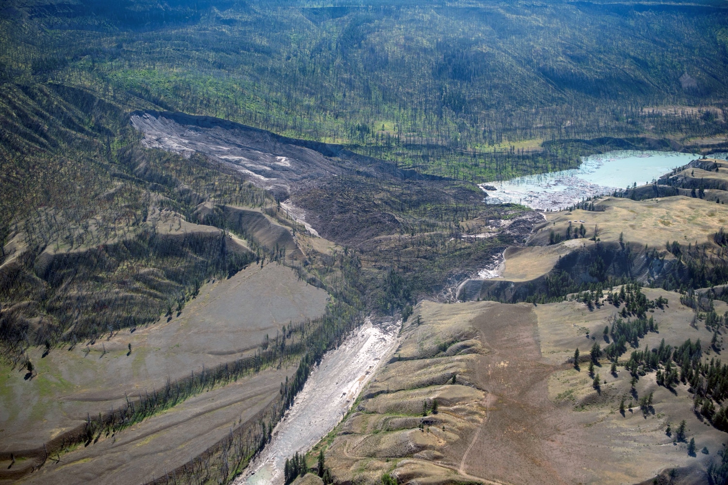
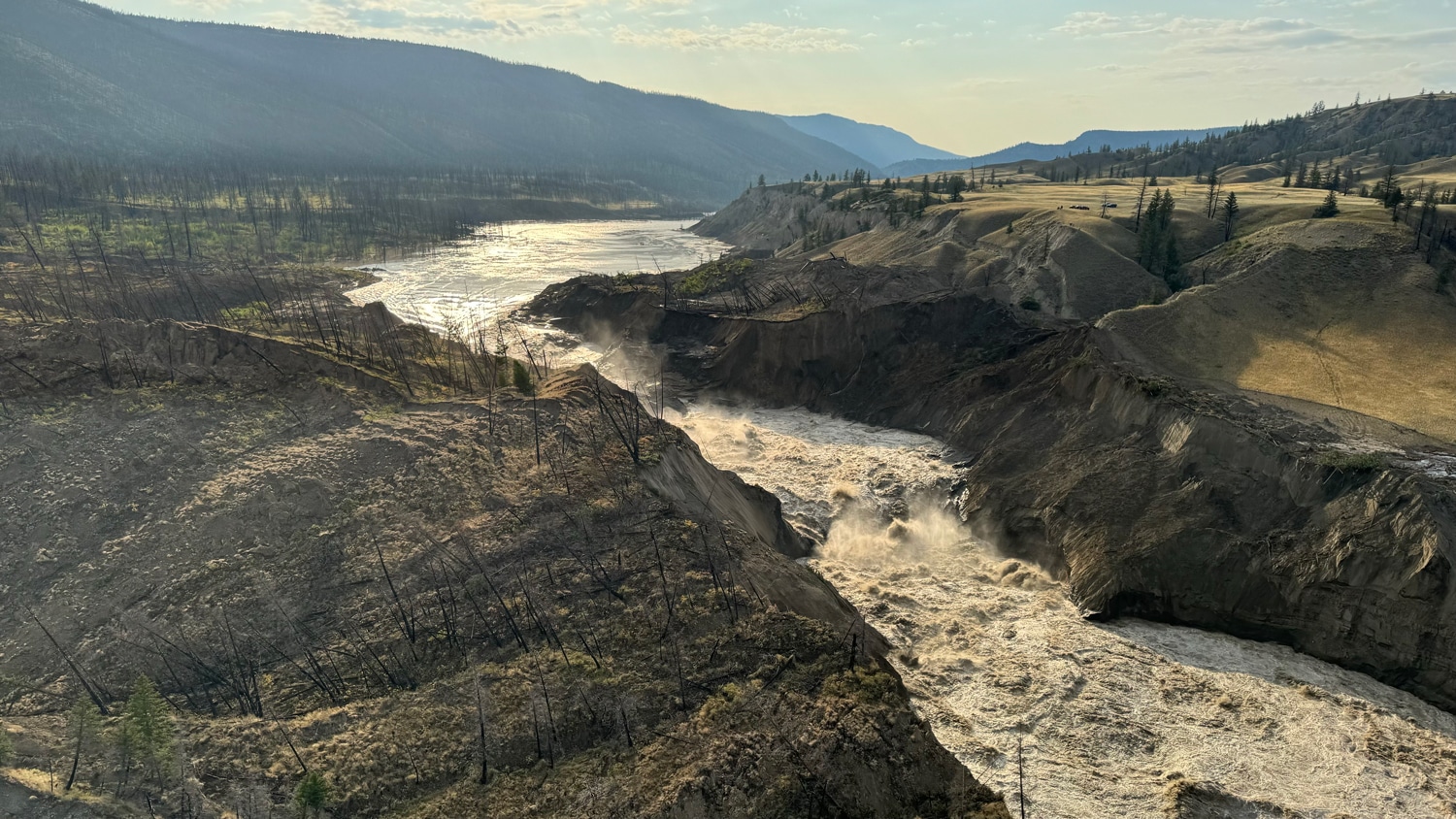
But if we cannot come together to protect what we both care about most — land and water and salmon — perhaps forces greater than us will settle things. In the summer of 2024, while my people and the Tsilhqot’in were going back and forth about whose claim to Farwell Canyon was more rightful and righteous, there was a sudden massive landslide. I’m not talking a hill caving in. I mean a thunderous, biblical churning that reshaped the entire complexion of Farwell Canyon, forming a massive earthen dam 2,000 feet wide and 100 feet deep, which created a temporary lake and prevented the ascent of all but a few hundred fish. My fishing buddy, Chief Willie Sellars of the Williams Lake First Nation, flew over the wreckage in a chopper. Global News and the CBC had him on air to talk about the disaster. About a week later, floodwater breached the dam, surging down the Fraser River to the ocean. My Secwépemc ancestors would have considered such a thing Coyote’s work, no doubt. And maybe it was.
So let me turn back to our oral histories for a final word. As I have said, my connection to Farwell Canyon goes back at least three generations to my pé7e, a St’at’imc from the Lillooet River, another tributary of the Fraser, which lies about 65 miles south of Farwell Canyon. Pé7e earned the right to fish Farwell Canyon in the old Indian way, honored since Coyote’s time: marriage. Pé7e, a bit of a Coyote himself, had nine Secwépemc kids and a herd of 100 wild horses in Canim Lake.
Pé7e’s people tell a story about two neighboring villages of St’at’imc and Skwxwu7mesh, who once lived in the mountains near the present-day town of Whistler. Like the Secwépemc and the Tsilhqot’in, these St’atimc and Skwxwu7mesh did not get along. They bickered constantly over who was better at this or that, and who had the greater claim to hunting grounds in the area. So, one day, a thunderbird, a mythic avian who shoots lightning from his eyes and flaps thunderbolts from his wings, who lived in the mountain above their villages, had enough. The thunderbird used his power, the storm, to cause an immense rockslide that killed all the villagers except for two: one St’at’imc, the other Skwxwu7mesh. Since then, our nations have understood that the territory around Whistler must be a shared hunting ground.
If we listen to the fish who are imperiled, the canyon that is crumbling, the Creator, the trickster Coyote — maybe there is a message in this story.
Here is my humble plea to my people and my enemy who have fished across the river from one another at Farwell Canyon for generations. Maybe it’s time we set aside our differences. Maybe, if we listen to the fish who are imperiled, the canyon that is crumbling, the Creator, the trickster Coyote, and other supernatural forces still with us — if we look at Farwell Canyon and this mythically proportioned calamity the way our ancestors would have — maybe there is a message in this story. That our people must get along and come together to protect our shared and cherished Farwell Canyon and the fish it provides.
But who am I to say? I’m not much of a fisherman. I’m just a mixed and mixed-up Secwépemc and St’at’imc man hoping that, many generations from now, my descendants will still be here, with their dipnets in the Chilcotin River, peering across Farwell Canyon with a mix of envy and admiration at our neighbors, enemies, and relatives, those mighty and beautiful Tsilhqot’in.
This is my praise song for Farwell Canyon — that glorious Coyote-blessed and bewitched cathedral of salmon — for my enemy who is also my relative, and for the fish we love and share.


.jpg)
If you would like to comment on this article, or anything else on Places Journal, visit our Facebook page or send us a message on Twitter.