
I could name a thousand conveniences of a safe, pleasant, well-repaired highway, both to the inhabitant and the traveller.
— Daniel Defoe, An Essay Upon Projects, 1698.
Before the Lake District of North West England was made famous by the Romantic poets who lived there, it was an inhospitable place. In the 1720s, a more worldly writer, Daniel Defoe, travelled around Great Britain in search of commerce and industry, hoping to find evidence that the newly united country was being remade by the kinds of improvements to “the lands, the trade, and manufactures” he had seen all around his London home. When he arrived at the old road that passed through the Lakes to the Cumbrian coast, he faced a forbidding prospect of unrelenting peaks and steep valleys, “the wildest, most barren, and frightful” lands he had ever seen. “I could not but be apprehensive for my neck,” he wrote. The “unpassable hills, whole tops, covered with snow,” signaled that “the pleasant part of England was at an end.” 1
To drive the A66 is to pass between worlds, from the apparently eternal mountains to the dynamic industrial coast — from the sublime to the subliminal.
He cannot have been too surprised. The widely circulated Britannia atlas — the first road map of Britain, published by the Scottish cartographer John Ogilby in 1675 — warned that there were only three advisable routes across the territory. 2 It was “as primitive and as out-of-the-world a place as could possibly be imagined.” 3 Apparently discouraged by the direct approach through the central Lakes, Defoe attempted to confine his movements to the low terrain that wrapped around the mountains, following in part an old Roman road on his journey to the west coast. There he visited Whitehaven, the “most eminent” coal trading port in England after Newcastle, where it was not unusual to see “200 sail of ships at a time” making out for Dublin; and Workington, at the mouth of the river Derwent, which would grow through similar trade to become a major site of steel production in the 19th and 20th centuries. 4
Defoe recorded these insights in a three-volume book, A Tour Thro’ the Whole Island of Great Britain, which was a powerful work of literary journalism, and some invention — reputedly informed as much by the writing of others as by the author’s own travels. He would have been influenced not only by Ogilby’s Britannia, but also by Christopher Saxton’s map of Cumberland and Westmorland, first published in 1576, which had no roads at all. Saxton depicted the coastal towns bounded on the west by a perilous ocean, complete with sea monsters, and on the east and south by strange-looking mounds representing the frightful lands Defoe avoided. 5 In the pre-Romantic western imagination, mountains were bleak and ignoble, little more than “warts, pimples, blisters, and other ugly deformities on the earth’s surface.” 6


Today, of course, the Lake District is one of the UK’s most cherished landscapes — a national park and UNESCO world heritage site — and for that we can thank the “revolution of perception” that occurred after Defoe’s time. As Robert Macfarlane observes, “The qualities for which mountains were once reviled — steepness, desolation, perilousness — came to be numbered among their most prized aspects.” 7 The Lake District as we know it was invented through the works of William Wordsworth, Samuel Taylor Coleridge, and other Romantic poets who settled or travelled there in the late 18th century, and wrote about the sublime and the picturesque in nature.
The scale of the landscape distorts perception, so that even at great speeds, one often feels a sensation of moving slowly, or not at all.
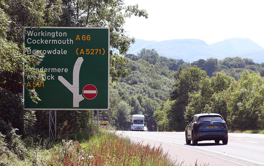
Now the park’s 20 million annual visitors experience a different sort of sublime, driving on the M6 motorway. Approaching the mountains from the south, as Defoe did, through the long, deep, flowing valleys between Lowgill and Tebay, the scale of the landscape distorts perception, so that even at great speeds, one often feels a sensation of moving slowly, or not at all. 8 Sometimes the spell is broken by the sudden thunder of low-flying Tornado GR4s on military exercise. From the motorway, park visitors turn west onto the A66, which cuts through the northern Lakes from Penrith to Workington. This road is a portal to another Cumbria, which for much of its history turned its back to the Lakes and faced outward to the Irish Sea. To take that short journey, some 45 miles, is to move between worlds, to pass from an apparently eternal and unchanging mountain landscape, to the historically dynamic industrial coast; from the locus of the Romantic sublime to a place whose cultural inheritance is buried or repressed — that is, subliminal.

The Quick Perspective of the Future
In the 1960s, the road that passed through the Lake District at Keswick was known as the A594. It was one of the old “trunk routes” that radiated out from London, and which were scheduled to be upgraded and widened as part of the Labour government’s plans for a new, modern Britain — a nation “forged in the white heat” of technological change, as Prime Minister Harold Wilson proclaimed. 9 In principle, it should not have been easy to impose this modernist vision in the celebrated Lake District, which had been designated a national park in 1951 and was assumed to enjoy protection from developments that would alter its “Wordsworthian” character. Indeed, the poet had resisted modern invasions of the place in his own time. 10
Wilson’s government believed an improved road, the A66, would save the port towns in West Cumbria, whose economic prospects had been shattered by deindustrialization. The Lake District, though, was considered “a national property,” and Wilson’s antagonists feared road expansion would bring heavy industrial traffic to West Cumbria and even more tourist traffic into the Lakes. 11 Both sides were aware that once the national park was breached in this way, perceptions of its cultural value could change. The government’s legal counsel even argued that the A66 would, in the end, contribute positively to the aesthetic appreciation of the landscape. “I will not be surprised,” he remarked, “if in years to come people stop to admire that bridge spanning the Greta Gorge and framing the scene.” 12


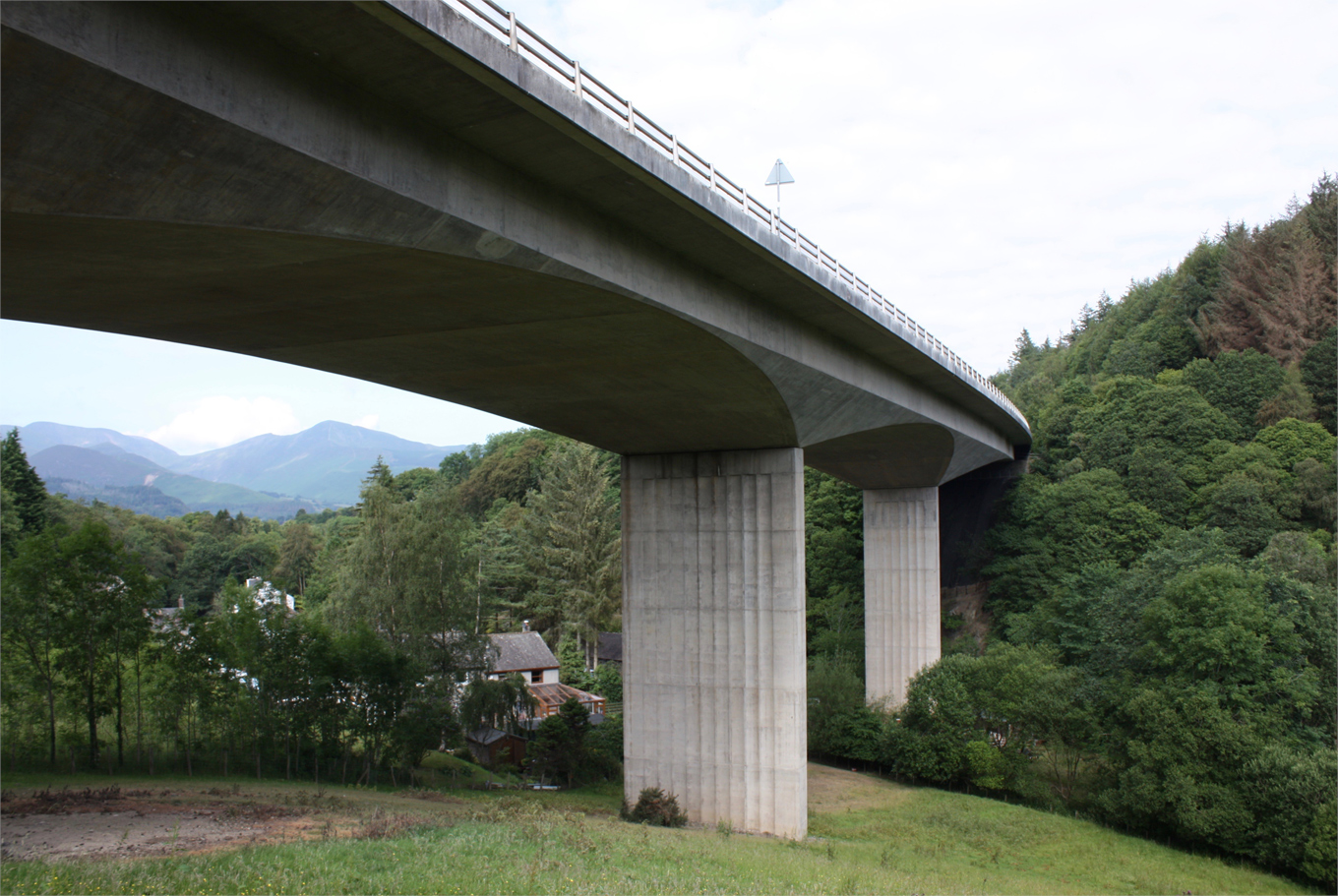
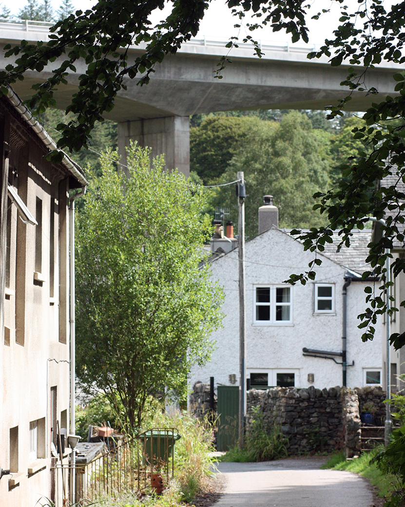
And so it is today. The underside of that sweeping curvature — a “four-span structure” with “chamfered piers” — is described by architectural historian Matthew Hyde as “elegantly brutal.” 13 Seen from a more withdrawn perspective, the bridge span spectacularly frames the vale of Keswick, where Coleridge lived, and presents a living diorama of the Lake District’s temporal layers, from the distant mountains formed millions of years ago, to the managed landscape of trees and houses, to the brutal imposition of the modern road, passage to the industrial west. In 1999, a plaque was installed to inform spectators that the Concrete Society had deemed the bridge Britain’s “Best Concrete Engineering Structure of the 20th Century.” If those who opposed the road expansion did not foresee that result, they nevertheless understood that people often come to like and admire what was once unwelcome.
In the 1930s and ’40s, similar battles were fought over the planting of electric pylons and overhead power lines in the Lake District and across the nation. 14 “There runs the quick perspective of the future,” wrote Stephen Spender, in his poem “The Pylons.” He imagined giant invaders looming over the land, “dreaming of cities” and dwarfing England, a mere green place, the “emerald country.” 15 But by mid-century, familiarity bred “resignation and even affection.” 16 Advocates for the humanized landscapes of modern England foresaw that the pylons would merge into a “man-made nature,” as “hedges, ditches, farm buildings, townscapes, factories and arterial roads” had before them. 17

A Pleasurable Terror
On a 1769 journey through Cumbria that shaped early Romantic perceptions of the Lake District, Thomas Gray — who had already published his experiences of travelling through another terrifying mountain landscape, the Alps — was forced to admit defeat after being unable to negotiate a particularly hazardous westward route around the imposing obstacles of Scafell Pike and Wasdale Head. “All further access is here barred to prying mortals,” he wrote in his diary. 18 He recalled a passage from Milton’s Paradise Lost in which Satan, on his journey to Earth, was plunged into the realm of Chaos and Night.
So eagerly the fiend
O’er bog or steep, through straight, rough, dense or rare,
With head, hands, wings, or feet pursues his way,
And swims or sinks or wades, or creeps, or flies 19
Such were the personified forces that watched over this land on the edge of Hell, a place of darkness and terror which Satan crossed on his way to Eden (also the name of a part of Cumbria that lies to the east, between the Lake District and the Pennines). Gray remarked that the local guides who knew the way past these obstacles seemed to be in collusion with the landscape to ensure that it remained a forbidding prospect to the stranger from more civilized parts.
In travel narratives from this era, the appreciation of a picturesque scene is often overtaken by a hint of danger. William Gilpin, in 1772, described the contrast between the view back to Grasmere Lake (where Wordsworth would make his home) and the view ahead to Dunmail Raise (a mountain pass) as one of those pleasurable terrors that exercised the Romantic imagination. The rising mountains formed a kind of “side-screen” as the valley narrowed toward his position, and the road ahead offered the prospect of “some dreadful deed lying in wait.” It would make a fine hiding place, Gilpin thought, for “a group of banditti.” 20

Romanticism flipped light into darkness, reason into fear, and it transformed the perception of the Lake District from a spectacle of ‘holy terror’ to a tourist destination where one might experience extreme — but pleasurable — sensations.
The Lake District was created through such accounts, most notably Wordsworth’s 1810 Guide to the Lakes. He perceived the infinity of nature in something as simple as a flowing river, which he regarded as proof of a spiritual dimension and a means of connecting the individual with the universal. Such ideas were enthusiastically received by educated readers who had been exposed to Enlightenment notions of a newly enlarged — an infinite — universe that was “at once vast, complex, and harmonious.” 21 As the parameters of knowledge shifted, so too did the possible dimensions of aesthetic experience. Romantic writers and artists sought experiences that would put them in contact with the infinite, especially travel to remote and extreme places. And walking among the mountains was a means of resisting that other Enlightenment tendency, to regard nature as a store of resources that new scientific knowledge might subjugate and harness for some calculable human end. 22 The Romantic worldview was opposed to a calculating mind like Defoe’s, which asked how “the plenty of nature” could be tapped for human endeavours. 23 Indeed, Defoe had already dreamt of something akin to a national highway system (in An Essay Upon Projects, 1698) which would improve Britain’s material wealth by connecting its burgeoning industries.
But one needn’t go anywhere to experience the infinite. Coleridge — in the grip of an opium habit — sat on the roof of his house, Greta Hall, watching the sky and recording the changes of light, and revelling in the tricks played on his imagination:
All this long Eve, so balmy & serene
Have I been gazing on the western Sky
And it’s Peculiar Tint of Yellow-green—
And I still gaze — & with how blank an eye! 24
Notwithstanding the difficulty of turning his atmospheric impressions into verse, he wanted to “wrap up” that view “in a pill of opium” and send it to absent friends. 25 From his house Coleridge could see what Thomas West described, in his 1778 Guide to the Lakes, as a perfect scene of “beauty, horror, and immensity united”:
you will on one side of the lake, see a rich and beautiful landscape of cultivated fields, rising to the eye, in fine inequalities, with noble groves of oak, happily dispersed; and climbing the adjacent hills, shade above shade, in the most various and picturesque forms. On the opposite shore, you will find rocks and cliffs of stupendous height, hanging broken over the lake in horrible grandeur some of them a thousand feet high, the woods climbing up their steep and shaggy fides, where mortal foot never yet approached. On these dreadful heights the eagles build their nests; a variety of water-falls are often pouring from their summits, and tumbling in vast sheets from rock to rock in rude and terrible magnificence: while on all sides of this immense amphitheatre the lofty mountains rise round, piercing the clouds. 26
Here Coleridge sat musing on the name of the river that ran past his house, which seemed to mirror his despair. Greta, he wrote, came from the German grieta — a loud cry or lamentation — which in Coleridge’s mind could only mean the “infernal” river Cocytus, “named of lamentation loud,” which flowed to the mythical Underworld. 27 The roar now is above, from the motor vehicles cross the A66 bridge that spans the gorge.
The virtue of this landscape, for Coleridge, was the possibility of mind-expanding experiences where he could locate the sublime, in all its “agreeable horror.” 28 Of course, he did not spend all his time at home, sitting on the roof. He liked nothing better than to get lost in the mountains, to face the “obscurity and darkness” that hung over the chasms, and be tested by nature’s obstacles and terrors. To this end, he invented a Romantic version of Russian roulette. As Macfarlane describes it:
Coleridge’s gambling worked as follows. Pick a mountain, any mountain. Climb to the top of it and then, instead of “winding about ’till you find a track or other symptom of safety” — instead of looking for the easy way down — wander on, and “where it is first possible to descend,” descend, and “rely upon fortune for how far down this possibility will continue.” 29
One particularly unwise adventure took Coleridge to the top of Scafell, the region’s highest peak, after which he faced a perilous descent towards the now infamous Broad Stand, “a steep giant’s staircase of rock slabs and sloping ledges.” He remained “calm & fearless & confident” and consumed by wonder as he looked down. 30 Romanticism flipped light into darkness, reason into fear, and through the imagination of people like Coleridge, it transformed the perception of the Lake District from a spectacle of “holy terror” to a tourist destination where one might experience extreme — but pleasurable — sensations. 31

Reality and Its Escape
Today the A66 is the usual entry point for the caravans and motor homes that converge on the central Lakes. The odd feeling of travelling toward a place that exists mainly as a “refuge from the real world” is underlined by the sight of these holiday vehicles, which vanish into blind openings that turn out to be carefully designed exits, decorated with rows of thick trees that conceal what lies beyond, and, from the other perspective, mitigate the aesthetic impact of the road on the park. 32 The occupants of these vehicles have often been portrayed as a bit strange (“people who enthusiastically participate in such recondite pastimes as reversing competitions,” Jonathan Meades once wrote), or the purveyors of blight (“there were many tin caravans on the coast,” Paul Theroux reported, “that would make a useful blaze”). 33 But I have come to feel some empathy with caravaners, to understand them as people who dream of an open space in which a shrunken form of domesticity — tiny bathrooms and cookers, small plates and teacups — makes contact with the infinite. The compact motor home needs something correspondingly vast — the sea, a giant mountain range, an endless desert, and so on — to justify its existence.
Now the park is overrun with caravaners, people who dream of an open space in which a shrunken form of domesticity makes contact with the infinite.
Continuing west on the A66, motorists leave the national park just before the exit to Cockermouth, Wordsworth’s birthplace. This is the cultural ecotone where the Lake District meets the coast. 34 A few doors down from the pub named after Wordsworth is another named for Fletcher Christian, the notorious sailor portrayed by Marlon Brando in Mutiny on the Bounty. And over those histories is now laid a new landscape, the “The Energy Coast.” John Dalton, a pioneer of atomic theory who, in his spare time, devised a method of calculating the altitude of Lake District peaks, was born in nearby Eaglesfield, and he lent his name to a research institute not far from Sellafield, a hub of the nuclear industry since the mid-20th century. After Cockermouth, the scenery flattens out into a coastal plain dotted with wind turbines. Here we find Workington and Whitehaven, which so impressed Defoe three centuries ago.
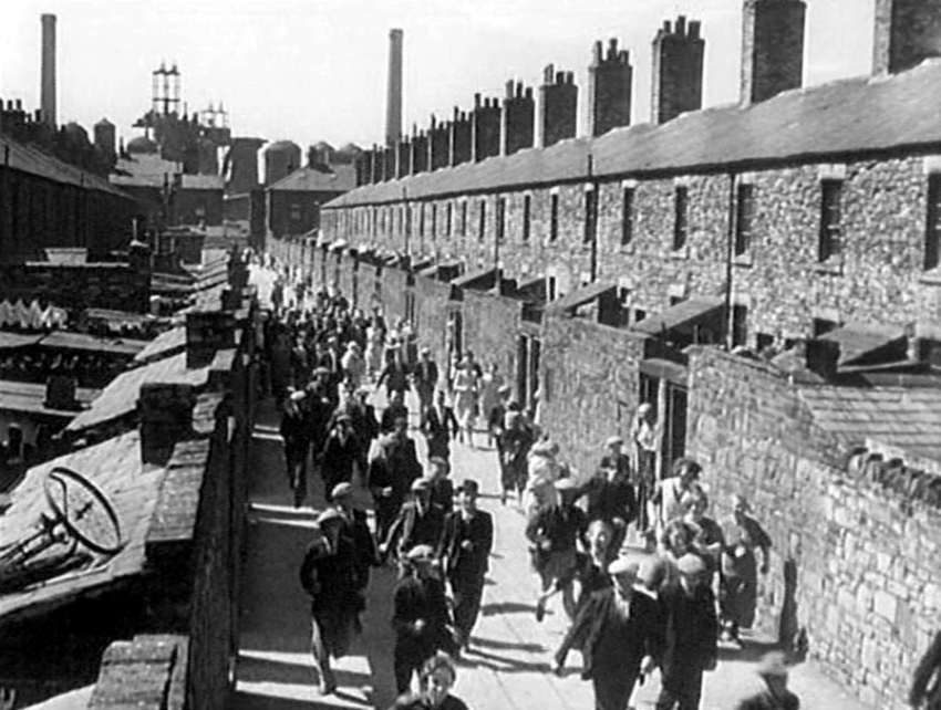
The geological upheavals that formed the Lake District also left great mineral riches in West Cumbria, notably a coalfield formed by the “the fossilized remains of swamp vegetation” and “luxuriant forests.” Small-scale mining began as early as the 13th century, when exposed seams on the surface were dug out. 35 By the 17th century, four enterprising families — Lowther, Senhouse, Christian, and Curwen — had exploited the coalfield from Whitehaven to Maryport and arcing inland toward Wigton. They built modern townscapes by the coast that stand today as the last remains of their world. 36 After the coal was exhausted, the region was known for the high quality of its hematite, which was mined late into the 20th century and used to produce steel that was shipped around the world.
If the Lake District became a place to “escape from reality,” then the landscapes of West Cumbria were the opposite. The industrial coast was darkened by grime and pollution. Hundreds of coal and iron ore mines ensured that “a whole underground world was opened to the presence of men and their occupations.” 37 The first sub-marine mine was located here, off the coast of Whitehaven, extending miles out to sea. So remarkable was the situation that “the mines became a regular attraction for genteel tourists, who found this industrial underworld a rich source of the exotic.” In this respect, at least, the Lake District and the coastal towns were not so different as they later seemed to be.

On the outskirts of Egremont, the last deep iron mine in Western Europe closed in 2007. Buildings used by the miners as changing rooms have been converted into an arts center.
In the words of historian J.M. Robinson, this is a place “partly very well known, and partly not known at all.” 39 Carol Reed’s 1940 film, The Stars Look Down — a blockbuster that preceded his noir classic The Third Man — was shot in and around the area we know today as West Cumbria, but his audience did not know it. The film aimed for universal appeal, examining the centrality of mining to the life of the nation, in a time when at least one in ten men worked underground. Today’s viewers might find it hard to grasp this resonance, but not many years had passed since coal miners led the General Strike of 1926, Britain’s “only epic class-confrontation,” and a key event in modern political history. Miners were heroic figures, risking their lives as capitalism’s greatest “symbolic victims and indomitable survivors.”
Cumberland (as it was then known) could easily have been taken to represent the essence of a dark industrial world. But Reed obscured matters by casting the local coalfield as an actor playing the part of County Durham — 90 miles away on the opposite coast. We can blame Wordsworth for that: by 1940, Cumberland was so firmly associated with the Lake District that it would have seemed an unlikely setting for the story Reed wanted to tell.
Not much remains of the mining landscape today, and it would be hard to retrace the steps of the screen stars and their film crews. So here, again, we see a contrast: between the sublime of the Lake District — an imaginary that is never erased, no matter how thoroughly it is overrun by motor homes — and the subliminal, subterranean history of West Cumbria. On the outskirts of the town of Egremont, the last deep iron mine in Western Europe closed in 2007. Buildings used by the miners as changing rooms have been converted into an arts center.

Nine Huzzas Rent the Air
As the old industries died out across the land, the air was cleared of smoke, dust, dirt, and chemical fumes, and the buildings and infrastructures sustained by those industries were preserved by a cultural heritage “industry” (as we say) that seems willing to accept any relic left standing. 41 Heritage has become a means of reviving economic fortunes in an age of tourism that recognizes new forms of pleasure. Visitors who reach West Cumbria today, perhaps at the end of a vacation through the Lake District, will find charming port towns with Georgian centers and attractive marinas, and they might imagine they have landed in a post-industrial world.
At the Workington end of the Sea to Sea (or C2C) cycle route, which stretches across Northern England, the view out to the Irish Sea takes in the massed ranks of turbines of the Robin Rigg offshore wind farm. Much like the A66 itself, the wind turbines are a symbol of how West Cumbria has survived by extending itself outwards through its infrastructure. That much has not changed since the old maritime routes were charted.

On the road up the coast, near the port, cooling towers and chimneys pour steam and smoke into the sky — though not so much as a century ago. Here the air is still a bit grungy, against the backdrop of the Lake District mountains. It is a fascinatingly “subnatural” landscape — all mud, dankness, and concrete rubble — where the land meets the sea. 42 Reading accounts of the celebrations that marked the opening here of Chapel Bank colliery, whose seams ran out and under the sea, we can recover a sense of how important the coal industry was to cultural life in the 18th century. “On Friday, about noon, the Sisterly Society went in procession to the pit,” reported the Cumberland Paquet. “These were followed by the miners, dressed in white flannel suits — the Honourable Society — the Friendly Society — the seamen. … Two marquees were pitched, and wine and cake were provided for all who chose to partake; several barrels of ale were also broached, and given to the populace. The procession surrounded the pit, which was then named Lady Pit, in the presence of several thousands, who rent the air with three times three huzzas.” 43
Where the A66 cuts through the center of Workington, it is flanked by two historic attractions. The old town around Portland Square preserves handsome Georgian houses, color-washed in the Cumbrian style; and Workington Hall, a large manor house now fallen into ruin, which was the seat of the Curwen and Christian Curwen families, who built up the town with the riches of its coalfield. And then the road comes to an inauspicious end, looking onto a pedestrianized shopping precinct guarded by a work of public art celebrating the town’s most famous export commodity. Once upon a time, Workington steel was shipped so far and wide, it was said that wherever railway tracks were laid, one could imagine they were made here. Now it is the A66 that connects Workington and West Cumbria to the world beyond. The artwork at its end — or its beginning — is made from steel offcuts of railway tracks, refashioned into an industrial version of a Doric column. It stands alone in space, holding up only itself.


_Cumbria,_England_(DerHexer)_2012-07-20.jpg)
If you would like to comment on this article, or anything else on Places Journal, visit our Facebook page or send us a message on Twitter.