
7:40 a.m. 8/30/2005: After Hurricane Katrina, floodwaters poured into New Orleans through levee and floodwall failures and enveloped City Hall and the wind-battered Hyatt Hotel, where local officials had set up emergency operations. [Image credit: Richard Campanella]
During: The Deluge
On Tuesday, August 23, 2005, tropical air fueled by unusually warm ocean water spiraled in an upward, counterclockwise direction over the southeastern Bahamas. The westward-edging, low-pressure column sucked increasing quantities of heated air into the system, growing it sufficiently for the National Hurricane Center to classify it as Tropical Depression 12, and by the next morning as Tropical Storm Katrina. By late Thursday afternoon, Category 1 Hurricane Katrina approached the metropolis of southern Florida with 75-mile-per-hour winds. The system and its heavy rains killed nine people in the north Miami area overnight and then, surviving the jaunt over the Florida peninsula, entered the Gulf of Mexico. 1
Although the 2005 hurricane season had been accurately predicted as an extraordinarily busy one, tropical activity had disarmingly abated during July and August, and most New Orleanians only passively noted the seemingly weak and distant storm. But awaiting Katrina in the gulf was a gigantic source of storm fuel: a loop current of deeply layered warm water, pulsating in from the Caribbean between Cuba and the Yucatán and breaking off into eddies through the Gulf of Mexico before exiting into the Atlantic between Cuba and Florida. With sea surface temperatures around 90 degrees Fahrenheit and without the reprieve of cooler subsurface waters, a system that made it into the gulf at this particular time would strengthen dramatically.
Computer models at first forecast storm tracks up the Florida peninsula, then westward over the panhandle, then further westward to the Alabama border, where so many storms had landed during the preceding 10-year surge in tropical activity. The farther west Katrina crept, the more energy it drew from the warm loop current, and the more seriously it threatened coastal communities.

The owner who pinned the cheerful note in this shop did not foresee the lengthy disruption that would follow Katrina. This place never reopened, but many unflooded commercial streets bustled with activity within two to three months. [Image credit: Richard Campanella]
Yet as schools and offices closed down in New Orleans on Friday afternoon, most conversation and email concerned weekend plans and next week’s business, not evacuations and possible closures, much less national calamity. It was not until that evening, when the forecast tracks started pointing to the Louisiana–Mississippi border and Governor Kathleen Blanco declared a state of emergency, that citywide attention turned to the heightening threat.
With Katrina a strengthening Category 3 storm and the notoriously divergent computer models now all ominously concurring on a Louisiana landfall, the central Gulf Coast population finally mobilized on Saturday. Emergencies were declared at the state level in Mississippi and the federal level in Louisiana, something rarely done before a disaster strikes. Officials activated the complex contraflow evacuation plan, allowing motorists to use incoming interstate lanes to flee the New Orleans metropolitan area. Many departed Saturday; more left Sunday, August 28, when the system strengthened to Category 4 and Category 5 levels within five hours. By late Sunday morning, with Katrina’s winds hitting 175 miles per hour, nearly all qualified observers confirmed a New Orleans–area landfall. Mayor C. Ray Nagin ordered a mandatory evacuation of the city, though no one seemed to know exactly what that meant, and many could not comply even if they wanted to.
By Sunday night the evacuation window had all but closed, as the initial feeder bands whisked over the city; the only choices now were to ride it out at home or take refuge in the Superdome. Roughly 100,000 New Orleanians — one in every four to five — remained in the city, and of those approximately 15,000 lined up outside the Superdome, expecting at least a safe if uncomfortable night in this shelter of last resort. A solemn and profoundly troubled air prevailed among the reporters and authorities on the local news stations that evening. No one could believe that the proverbial Big One, the topic of endless planning scenarios and stern authoritative admonitions, the butt of countless doomsday jokes and glib clichés, was finally upon New Orleans, all within a summer weekend.
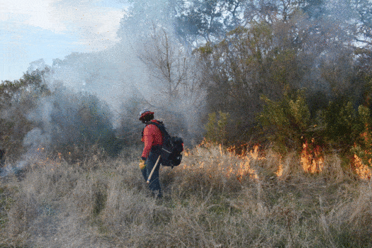
Overnight, Hurricane Katrina’s low barometric pressure and high winds sucked up a dome of gulf water and blew it north and northwestward into the Mississippi Gulf Coast and Louisiana deltaic plain. Shallow coastal depths reverberated the vertically churning water upward, further heightening the dome-shaped, landward-moving surge. Under natural conditions, hundreds of square miles of wetlands would have absorbed or spurned much of the intruding tide. But a century of coastal erosion had cost the region precious impedance, while a labyrinth of man-made navigation, oil, gas and drainage canals served as pathways for the surge to penetrate inland. The funnel formed by the Gulf Intracoastal Waterway (GIWW) and the Mississippi River-Gulf Outlet (MR-GO) allowed Katrina’s surge to swell waters 16 feet above normal levels in the circa-1920 Industrial Canal. Pressure built on the floodwalls and levees and upon the high-organic matter soils beneath them. Seepage began to trickle into the topographical bowls on the other side.

Katrina’s surge swept these fishing vessels onto land, crippling the Plaquemines Parish seafood industry for months. [Image credit: Richard Campanella]
As dawn broke and the storm approached the shore, waters began to overtop the GIWW guide levees in the city’s undeveloped eastern flanks and the MR-GO guide levees behind the Bayou Bienvenue marshes north of St. Bernard Parish and the Lower Ninth Ward. Shortly after, a breach — that is, a structural failure, as opposed to overtopping — formed in the western floodwall of the Industrial Canal, sending saltwater into the streets of the Upper Ninth Ward. A similar leak developed on the 17th Street Outfall Canal, wetting adjacent streets in Lakeview.
Hurricane Katrina made landfall at 6:30 a.m. over Louisiana’s Barataria Basin, between Grand Isle and the mouth of the Mississippi. The eye of the storm passed over the river towns of Empire and Buras, then over the eastern St. Bernard Parish community of Hopedale, about 25 miles east of downtown New Orleans. The coiling mass of storm clouds spanned from central Louisiana to western Florida; the outermost feeder bands stretched from the Texas hill country to the Georgia coast, from the Yucatán to the Appalachians.
Although Katrina’s winds had abated to Category 2 levels and lower, its storm surge retained the Category 5 momentum. Gulf waters swelled 10 to 30 feet above normal sea level, inundating 200 miles of coastline across four states. Lake Pontchartrain swelled to almost nine feet above normal, while the Mississippi River, which had been gauged at a typically low late-summer stage of about four feet above sea level, rose to nearly 16 feet and spilled laterally into lower Plaquemines Parish.
Pressure mounted on the soft marsh soils beneath the Industrial Canal’s floodwalls. The concrete-encased steel sheet pilings did not penetrate the earth deeply enough to curtail the seepage. Finally, between 7:00 and 7:30 a.m., two gigantic sections of the Canal on the Lower Ninth Ward side, respectively spanning more than 200 and 800 feet, caved in from below. A torrent of saltwater 14 feet above normal gushed into a neighborhood that lay as low as four feet below sea level. High-velocity rapids knocked houses off their pilings, blew down walls, and sent residents scrambling to their attics or roofs if they could — or else to a terrifying death drowning in their own homes.

7:46 a.m., 8/30/2005: Poydras Street is desolate, and thousands remained trapped in the damaged Superdome (right background), while tens of thousands huddled in attics or on rooftops as the deluge deepened. Hundreds had already perished, although world media hadn’t yet figured out what had transpired. [Image credit: Richard Campanella]
What the Lower Ninth Ward experienced first, St. Bernard Parish experienced moments later. Both communities — despite the racial and class tensions that had divided them for a generation — shared the same hydrological basin and the same sad fate. Floodwaters deepened when overtopping waters from MR-GO, as well as widespread disintegration of its worthless guide levee, delivered additional water into the basin from the north. Levee failures had turned a weakening, off-target storm into an unfurling catastrophe. And it was not yet midmorning.
The same combination of multiple overtopping and breaching that flooded basins south of the GIWW and MR-GO navigation canals proceeded to occur on their north side. By 9:00 a.m., most of low-lying New Orleans East and its vast acreage of circa-1970s subdivisions — built almost entirely at grade level — lay under saltwater. Around the same time, breaches multiplied and worsened on the outfall canals connected to Lake Pontchartrain: at two spots on either side of the London Avenue Canal, at a preexisting low spot on the Orleans Avenue Canal, and at the two-hour-old leak on the 17th Street Canal, which widened into a 458-foot-long catastrophic collapse. Now Lakeview experienced the same high-velocity blast that the Lower Ninth Ward suffered earlier. The multiple failures meant that all three of Orleans Parish’s major east-bank hydrological basins — the Lower Ninth Ward, New Orleans East, and the city’s heart between the Industrial Canal and the Jefferson Parish line — were now filling with saltwater. St. Bernard Parish to the east fared even worse, while Jefferson Parish to the west saw rainwater and spillover from the lake accumulate in low spots because its pump operators had been evacuated for fear of their lives. Neighborhoods in Jefferson Parish’s Hoey’s Basin, which is hydrologically connected to Orleans’s drainage system, suffered deep flooding as well. Swollen gulf water would continue to pour into the metropolis’s gravely compromised levee “protection” system for hours and days to come.

Former home of the author and his wife, in Waveland, Mississippi, fifty miles east of New Orleans. The circa-1926 shotgun house had easily survived Hurricane Camille and other gulf storms. [Image credit: Richard Campanella]
By late morning, Hurricane Katrina had made its second landfall near the mouth of the Pearl River along the Louisiana–Mississippi border. The Mississippi Gulf Coast towns of Waveland and Bay St. Louis, in the northeastern quadrant of the storm’s track, bore the full strength of Katrina’s 100-mile-per-hour winds and the maximum 29-foot-high storm surge (recorded off Biloxi, the highest ever in the region). Communities within a half-mile of the coast were wiped off the face of the earth. In New Orleans, strong winds peeled off the white surface coating of the Superdome and broke two six-foot holes in the roof, terrifying the thousands of frightened evacuees within the darkened and sweltering interior. Denizens of higher ground who rode out the storm at home experienced the same moment-to-moment apprehension of winds rocking their houses and rattling roofs, windows and doors. What few realized, of course, was that their fellow citizens faced not only these same fierce gusts but also deadly rising water.
The southern Mississippi landmass deprived Katrina of its warm-water fuel source, weakening the system to tropical-storm levels as it pushed inland, but not before it buffeted the southern half of the state as well as the eastern parishes of Louisiana. Winds, now from a westerly direction, died down by late afternoon in New Orleans.
Many journalists, overly focused on Katrina’s east-of-the-city track and diminishing intensity, mistakenly reported Monday afternoon that New Orleans had, as the infamous cliché put it, “dodged the bullet.” Many residents, evacuated and otherwise, went to bed prepared to return home, pick up branches, fix roofs, and resume their lives. It was not until Tuesday that they learned a jolting new truth — one that, in fact, was as old as the city itself. The flood-protection and drainage systems had not neutralized hydrology and topography; New Orleans’s ancient geographies of hazard, supposedly subjugated by technology generations ago, revealed their obscured relevance. Centuries of manipulating the deltaic plain had allowed the enemy to get too close to the fort. Decades of subsidence had turned the fort into a vulnerable bowl. And years of under-engineered, cavalierly inspected, and poorly maintained levees — with culpability at federal and local levels — had turned the bowl into an impending catastrophe.
Social unrest fomented among the trapped, thirsty and hungry citizenry. Looting — sometimes out of genuine need for food and water, other times for opportunistic thievery or sheer vandalism — became so rampant that already overwhelmed police chiefs and politicians generally paid it lip service or ignored it entirely. Officials called for the evacuation of the tens of thousands of people who remained in the city, but no mechanisms were in place to implement this, nor were any on the way. Crowds of the poorest citizens swelled to as many as 45,000 at the damaged Superdome and at the Morial Convention Center, both of which were unprepared for the crush. Scenes stereotypical of Haiti or Bangladesh, with all the ugliest of connotations, played out in downtown New Orleans and were broadcast worldwide. Elders, the infirm and children suffered the most; some youths exploited the chaos by looting, brawling and allegedly shooting at rescue workers.
Efforts to plug the 17th Street Canal breach with helicopter drops of sand failed utterly. Only when Lake Pontchartrain’s high waters drained sufficiently back into the Gulf of Mexico on Wednesday and Thursday did water cease entering the city, allowing for the makeshift repair of the levees.

A city under water produces countless tons of household debris, not to mention ruined construction materials and wrecked vehicles. [Image credit: Richard Campanella]
With Katrina’s winds long gone and the floodwaters no longer rising, New Orleans now grappled with another crisis: social disintegration. Police had to be called off search-and-rescue missions to control pillaging and chaos. Stranded crowds suffering deplorable conditions at the Superdome and later the convention center started making their way up exit ramps and onto interstates and bridges in search of any alternative to the hell below. The line between victim and perpetrator blurred in the eyes of overstressed authorities, occasionally leading to ugly confrontations and injustices. Buses to evacuate the desperate masses were few and slow in coming; the first were able to depart for Houston on Wednesday. The shocking spectacle of a modern First World society fracturing apart within the borders of the wealthiest and most powerful nation on Earth was headline news worldwide, for days and weeks.
Crises multiplied and intensified; what started as a disaster that turned into a catastrophe was now looking like an apocalypse. Bandits and authorities engaged in shoot-outs. Gas bubbled up from floodwaters and burned, like scenes from hell. Fires broke out citywide, and firefighters could neither reach nor douse them. Plumes of smoke rose across the skyline. An anguished Mayor Nagin, his city at the darkest moment in its history and seemingly abandoned by the nation, issued a “desperate S.O.S.” to the world via an emotional interview on WWL radio. “Don’t tell me 40,000 people are coming here,” he raged. “They’re not here. It’s too doggone late. Now get off your asses and do something, and let’s fix the biggest goddamn crisis in the history of this country!” Federal response in the form of armed troops, supplies, buses, medical attention and, most importantly, communication and coordination finally began to trickle in late Thursday. It would take a full two to three days before they could stabilize the degenerating conditions in the ravaged city, 80 percent of which was underwater, and evacuate the stranded to Houston or elsewhere.
By this time, pundits and the national press had started to remark openly about what had been silently obvious to television viewers: The vast majority of the people stuck in the cauldron of the calamity were poor and black. A national conversation — conducted in tones ranging from cautious explanation to righteous indignation — ensued about race, poverty, history and New Orleans society. The disaster-turned-catastrophe-turned-apocalypse was now becoming a troubling commentary about America. The “Lost September” of 2005 will be remembered by New Orleanians — scattered nationwide and humiliatingly dependent on the kindness of strangers — as among the most difficult of times. Unknowns haunted every aspect of life, from food, clothing and shelter in the near term, to the whereabouts of loved ones, to housing, finances, education and employment in the long term. Backdropping this angst was the greatest unknown of all: the very survival of the metropolis. Once among the most diverse and colorful assemblages of humanity on the continent, regularly predicted to rank among the world’s great cities, New Orleans in September 2005 stewed in its own filth, empty, broken, moldy and silent.

Hard lines in soft environments: Much of the Mississippi Delta’s land loss is due to the excavation of oil, gas, navigation and other man-made canals, which cause salt-water intrusion, swamp die-off, erosion and surge funneling. [Image credit: Peter Hermens/David Waggonner–Dutch Dialogues, 2009]
Before: Environmental Manipulation
Initial analyses characterized the post-Katrina flooding as the result of a levee system overwhelmed by natural forces — a natural disaster. Only later did it become clear that the real cause of the flooding was the inadequacy of the system, which failed due to decades of underfunding, shoddiness, incompetence and/or outdated science. But what allowed the storm surge to get so close to the city in the first place? The answer lies in the relentless human manipulation of the deltaic environment starting in the eighteenth and nineteenth centuries, but mostly occurring during the long twentieth century, from 1890 to 2005.
Modern levee construction and municipal drainage effectively ended the occasional flooding — from river, lake or sky — that frustrated New Orleanians in historical times. 2 These interventions also inadvertently eliminated incoming freshwater and sediment, removed the water component from the soil body, and allowed organic matter to decompose. Fine sand, silt and clay particles settled into the resultant air cavities, compacting the soil and lowering its elevation. The result: soil subsidence.
Soil subsidence had been observed in New Orleans for many years in many places. A document submitted to Congress in 1860 reported that the “St. Charles Hotel [had] sunk 36 inches; St. Patrick’s Cathedral even more; the St. Louis Hotel about 24 inches [and the] Custom House [by] 20 inches.” 3 This type of sinkage was caused by overburden: heavy structures compressing the soft soils on which they rested.
What was happening in the early 20th century, however, was different; it was systematic and widespread, like a geological disease rather than a localized wound. Vast acreages with zero overburden began to subside annually by multiple millimeters or centimeters. By 1935, roughly 30 percent of the urbanized land surface had fallen below sea level. 4 Subsidence worsened even as more and more people moved into subsiding areas. While the vast majority of New Orleans’s 300,000 residents lived above sea level in the early 1900s, only 48 percent remained above sea level in 1960, when the city’s population peaked at 627,525. Fully 321,000 New Orleanians in that year resided in the 20th-century subdivisions built on lakeside lowlands — which had already dropped vertically by one to two meters below sea level.

Outfall canals draining into Lake Pontchartrain once remained ungated because authorities worried that closing them in advance of hurricanes would diminish their ability to pump rainwater out of the city. That policy was reversed after Hurricane Katrina’s surge ruptured multiple floodwalls along the canals.
Subsequent years saw tens of thousands of New Orleanians migrate horizontally as well. They departed Orleans Parish neighborhoods for social and economic reasons, not for any sense of environmental hazard. The Crescent City’s population dropped by 23 percent from 1960 to 2000, representing a net loss of 143,000 mostly middle-class whites to adjacent Jefferson, St. Bernard, and St. Tammany parishes or beyond. Within the remaining Orleans Parish population, 121,000 New Orleanians — many of them middle-class blacks — internally migrated from higher historic neighborhoods to low-lying subdivisions east of City Park and into New Orleans East, which offered suburban-sized lots, modern housing, less congestion, and an ample inventory of multifamily housing accepting government-subsidized rent vouchers. By the end of the 20th century, half of the city proper and the metropolis south of Lake Pontchartrain had sunk below sea level, in some areas by two to three meters, while 62 percent of New Orleanians lived below sea level. Convinced that infrastructure and technology had neutralized historical hydrological hazards, hundreds of thousands of New Orleans–area residents unknowingly increased their exposure to environmental hazard.
Falling below sea level is hazardous because incoming water that ordinarily would drain off a tapered surface now becomes impounded by a collapsed surface and must be pumped out. The municipal drainage system uses enormous screw pumps for precisely this purpose, lifting and ejecting runoff through outfall canals and into adjacent water bodies. Where those pumps are located is critical. A planning decision made when the system was being designed in the 1890s positioned the pumps directly behind the urbanized area, along the edge of the backswamp. It seemed to make sense: Runoff would be collected at low spots behind the city, at which point the pumps would mobilize the water through the canals and over the levees into Lake Pontchartrain. What the engineers failed to appreciate was that the very success of their project would cause soils to subside and encourage urbanization on the newly dried former swampland beyond the pumps.
Within a few decades, thousands of people lived all around the pumping stations and among the outfall canals, which had to be lined with levees and, later, floodwalls. These neighborhoods subsided to the point that the canals now flowed above the rooftops, because the pump-enabled lifting of the water occurred at the canals’ inner-city headwaters rather than at their lakeside discharges. Making matters worse was the fact that the outfall canals communicated openly with the surge-prone Lake Pontchartrain, which was not controlled by floodgates. Federal proposals to install such gates were resisted locally because they would reduce the capacity of the drainage system to pump out runoff.
The circa-1890s siting of the pumping stations proved to be a dreadful planning oversight. Fortunately, planners in Jefferson Parish and eastern New Orleans learned from the mistake when they designed their systems in the 1950s and ’60s. They positioned their pumps along the lakeside periphery, expecting that the basins they drained would subside and populate. For this reason, outfall canals in the suburbs flow below street-grade level and do not require levees or floodwalls because the runoff is lifted at the last moment, just prior to being ejected into the lake. This explains why there are no levees intruding into the Jefferson Parish and eastern New Orleans hydrological basins but three such levees intruding into the “old Orleans” basin. The suburban drainage canals caused no significant problems during Hurricane Katrina; those in old Orleans caused catastrophic problems.
Below-grade canals do, however, come at a cost: They increase subsidence rates because they more effectively remove groundwater. Some of the lowest spots in the urban delta — 10 to 12 feet below sea level — are in eastern New Orleans and Jefferson Parish.
Subsidence alone constitutes a tolerable urban problem. In the face of eroding coasts and rising seas, however, it can be deadly. A century of environmental manipulation brought those rising gulf waters closer and closer to the subsided metropolis. The three major navigation canals — again, the Industrial Canal (1918–23), the Gulf Intracoastal Waterway (1930s–1940s), and the Mississippi River–Gulf Outlet Canal (1958–68) — allowed saltwater to intrude into the ragged edges of the deltaic plain. Wave action eroded saline marshes, and salinity killed freshwater cypress swamps, allowing more saltwater to intrude and repeating the cycle of ecological destruction until it brushed against the levee-lined perimeter of the million-person conurbation.

Containerization radically altered the economics and geographies of the Port of New Orleans, concentrating activity in uptown container facilities (above) freeing up miles of old wharves. The ongoing “Reinventing the Crescent” effort seeks to reconnect city-dwellers with the river by converting old shipping and warehousing areas to green space, recreational facilities, and promenades. [Image credit: Jaap van der Salm/David Waggonner–Dutch Dialogues, 2009]
An extensive network of oil and gas canals instigated the same cycle throughout the Louisiana coastal region: intrusion, wave action, swamp die-off, erosion. Worse yet, the canals’ guide levees and spoil banks served to channelize storm surges and funnel them inland, then impound those same waters when they tried to flow back to the sea. Additionally, the control of the Mississippi through artificial levees — commenced in the 1720s but augmented dramatically in the late 1800s and again after the Great Mississippi River Flood of 1927 — starved the deltaic plain of replenishing freshwater and floodborne sediments. Invasive nutria (Myocastor coypus) devoured marsh grasses and exacerbated land loss, while the global climate warmed and sea levels rose.
As a result of all these factors, Louisiana has lost roughly 2,000 to 2,300 square miles of coastal wetlands — about one-third of the Louisiana deltaic plain — since the 1930s. During the 1970s and ’80s, 25 to 35 square miles of marsh disappeared annually, a pace of loss well over 20 times swifter than the Mississippi River took to build those wetlands in the previous 7,200 years. The rate slowed somewhat in the ’90s and ’00s, not because the problem had been in any way solved, but because so little land remained to be lost. Three hundred years of environmental alteration, particularly in the past century, have essentially shifted the source of the New Orleans flood threat from the Mississippi River to the Gulf of Mexico. It has also partially transformed the Mississippi Delta from a river-dominated system to one dominated by coastal wave action.

Lessons learned from the Great Mississippi River Flood of 1927 inspired construction of the Bonnet Carré Spillway in the 1930s. Instead of restraining the river during high water with “levees only” (as the old policy had it), the spillway accommodates the will of the river by diverting excess water into Lake Pontchartrain. Here is the April 2008 opening, the spillway’s ninth since 1937. [Image credit: Richard Campanella]
Coastal wetlands protect New Orleans because they buffer hurricane-induced gulf surges and help prevent them from reaching the bowl-shaped city. Any form of friction and impedance that can be inserted between open water and populated areas — barrier islands, marshes, swamps, vegetation, ridges — serves somewhat to reverse incoming surge. Centuries of environmental manipulation have greatly diminished the delta’s ability to build that buffer and undermined the buffer it had built during previous millennia. Scientists debate the exact relationship and ratio between coastal wetlands and storm surge, but everyone agrees that more of the former means less of the latter.
New Orleans’s extraordinary geophysical problems overshadow its numerous routine environmental hazards. For example, high levels of soil lead, associated with lead-based paint, occur where automobiles and wooden housing stock are concentrated. The nearby River Road industrial corridor, between Baton Rouge and New Orleans, is described by many as “cancer alley.” Atrazine, arsenic, total coliform bacteria, and other contaminants have been detected in the city’s Mississippi River water source. Old industries and municipal dumps left behind numerous brownfields and other potentially hazardous areas, such as the Agriculture Street Landfill, where residential populations later settled. Combined with deeply rooted social, educational and economic vulnerabilities, the delta’s myriad geographical hazards set the city on a tenuous footing and heightened its urban risk. A sufficiently strong tropical storm was all that was needed to cause catastrophe.

Comments are closed. If you would like to share your thoughts about this article, or anything else on Places Journal, visit our Facebook page or send us a message on Twitter.