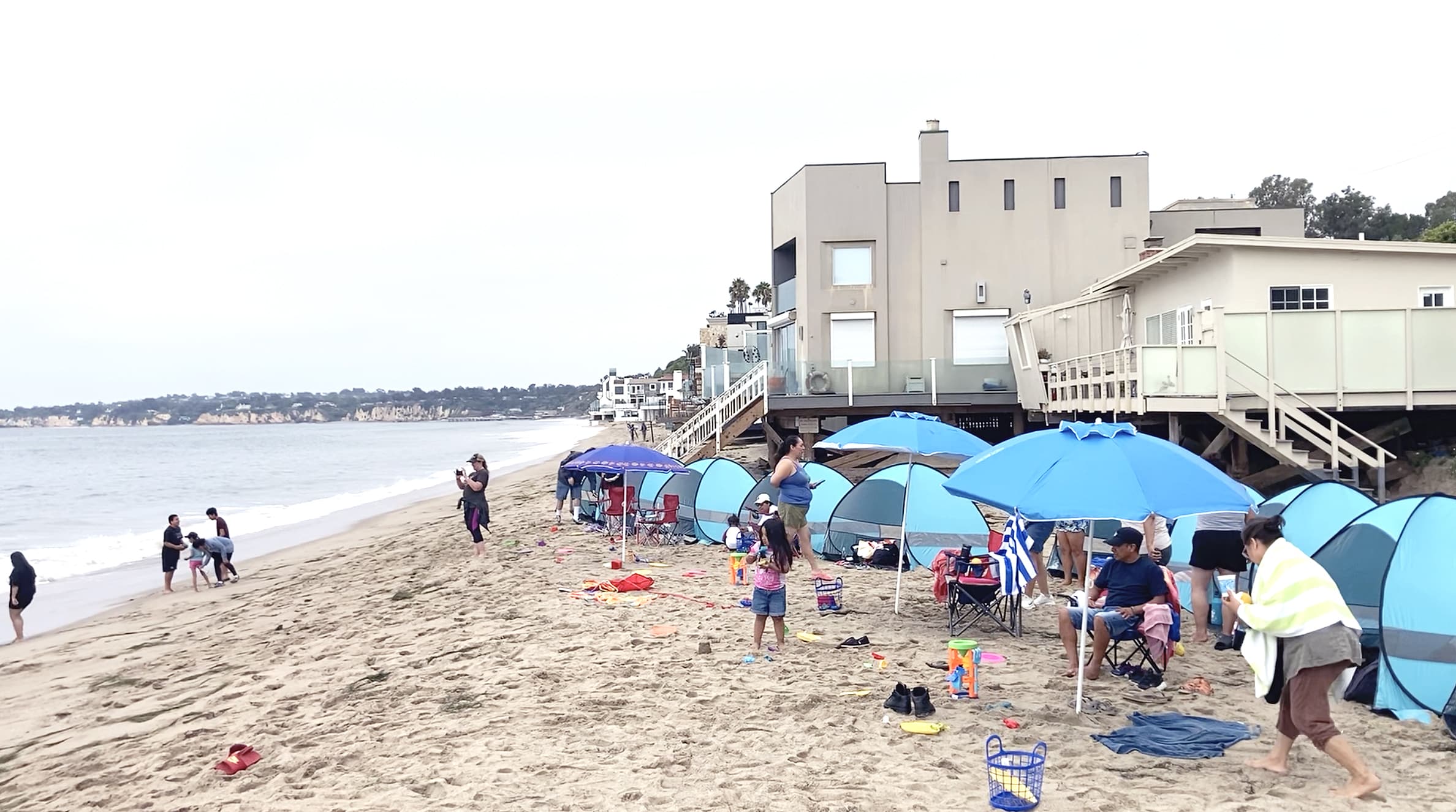
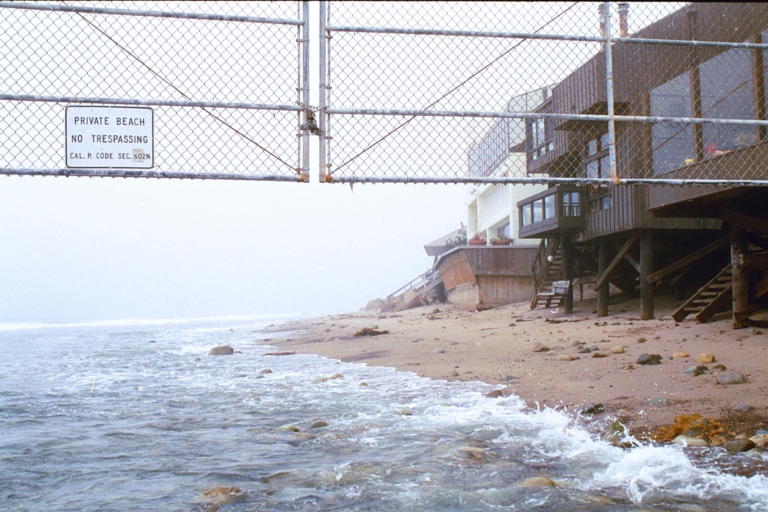
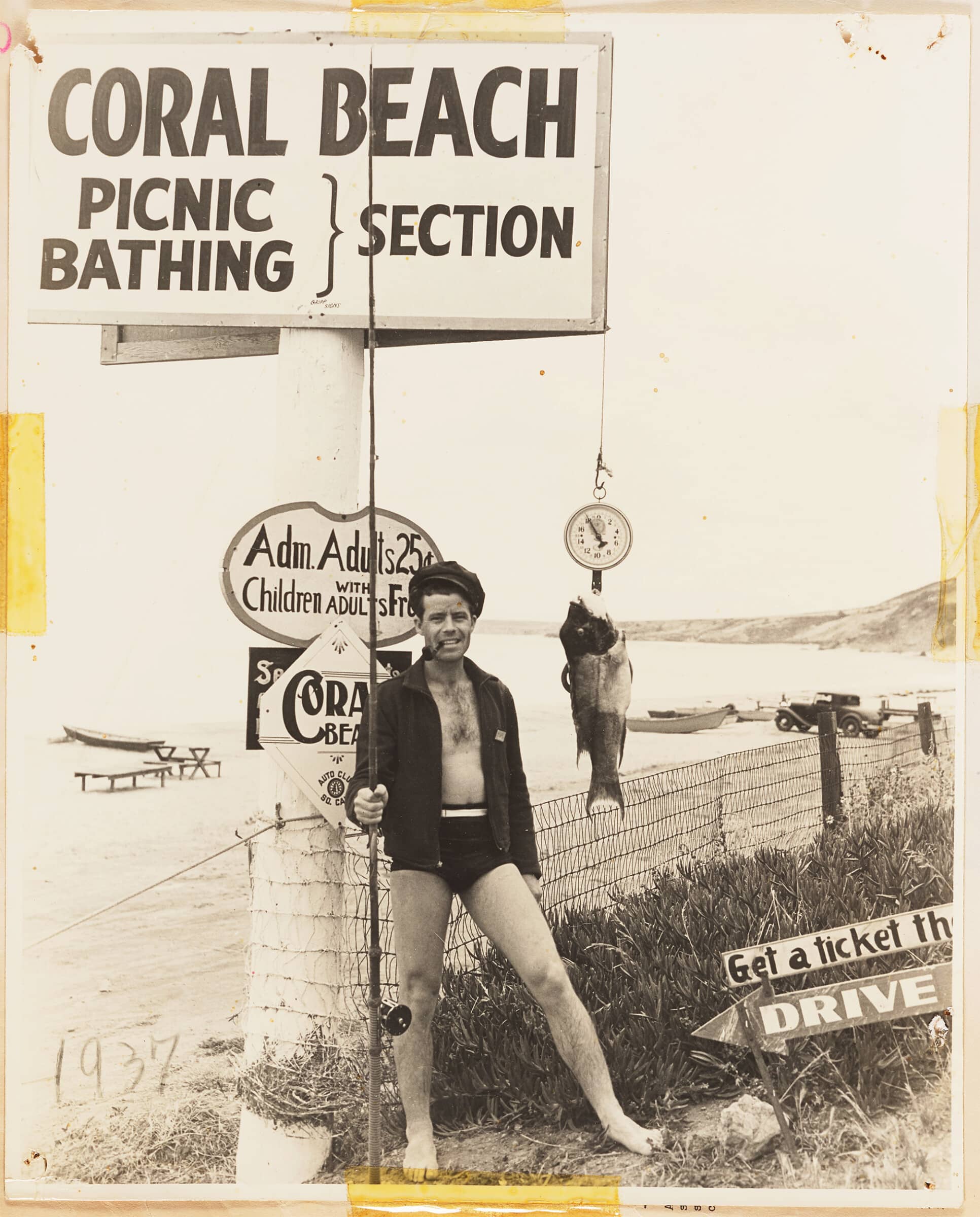
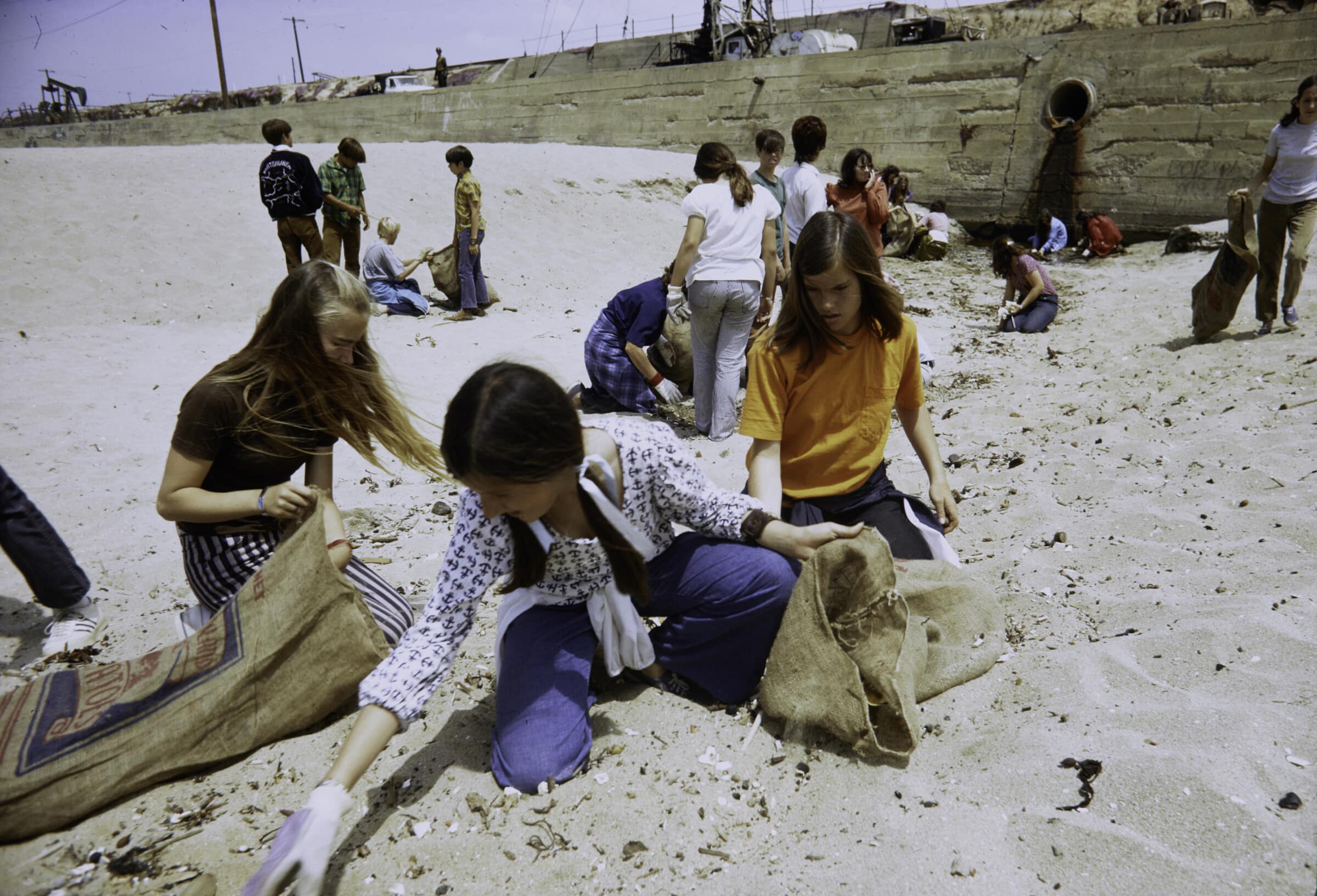
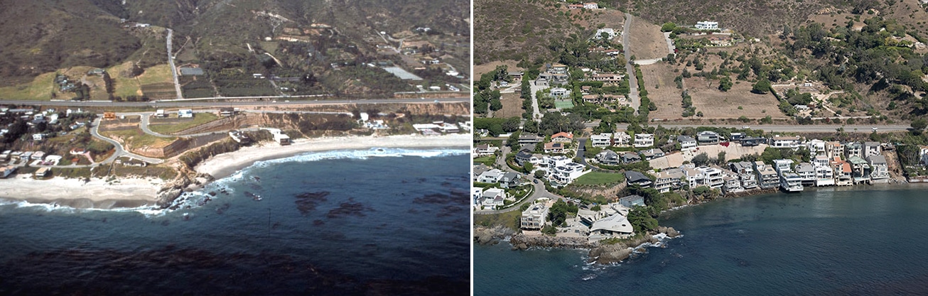
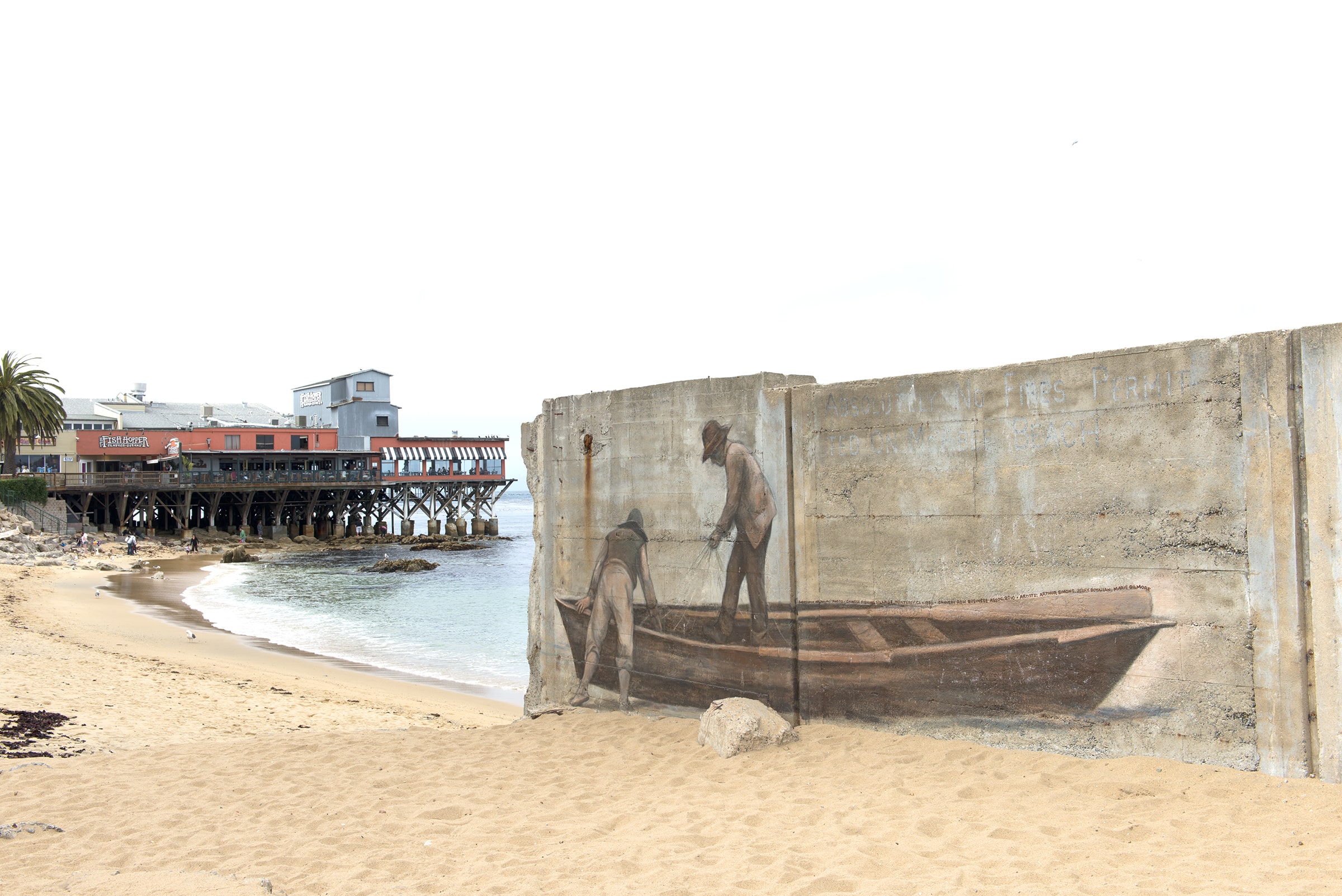
On an overcast, cool morning in August 2023, Rosa Bautista and I were chatting on Escondido Beach in Malibu, California. Bautista asked me to take her photo. She stood in front of a white, wooden deck attached to a multi-million-dollar home. I carefully framed the shot: Bautista, the deck, the house in the background, and a hand-painted sign reading “Private Beach.”
Bautista was then Chief Advisor & Executive Operations Manager at Mujeres de la Tierra, an L.A.-based environmental justice organization. She was there that morning preparing for a beach visit from residents of majority-Latinx Los Angeles neighborhoods, including Cypress Park and Lincoln Heights. Mujeres de la Tierra organizes these visits a handful of times over the course of a summer; soon, about a dozen families would arrive, with children of all ages.
Outings to the beach should be enjoyed by all Angelenos. Unfortunately, that’s not been the case.
Many of the adult and teenage attendees at Mujeres de la Tierra events — sometimes as many as 70 percent — are visiting the beach for the first time. This shouldn’t be true. The attendees live only about 30 miles from Malibu, one of the most striking coastlines in the world, and there’s plenty of space — 27 miles of public coast in Malibu alone. Outings to the beach should be enjoyed by all Angelenos, but unfortunately, that’s not been the case. For reasons related to structural racism and poverty, Los Angeles’s Latinx residents are particularly beach-deprived.
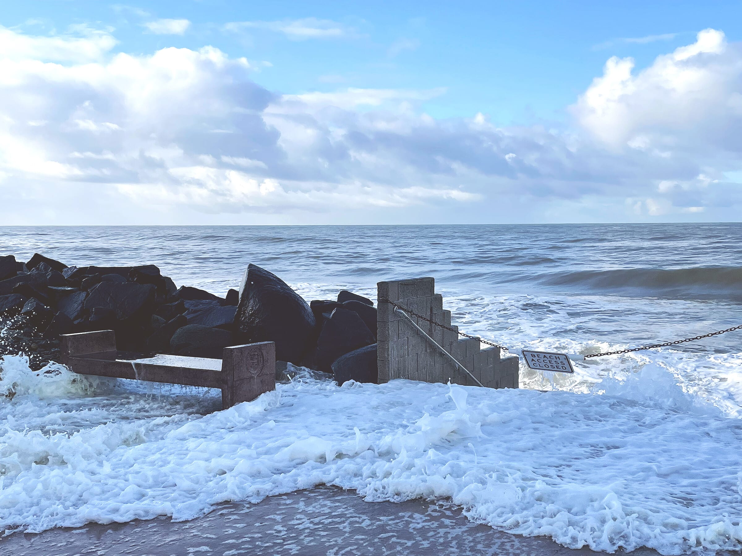
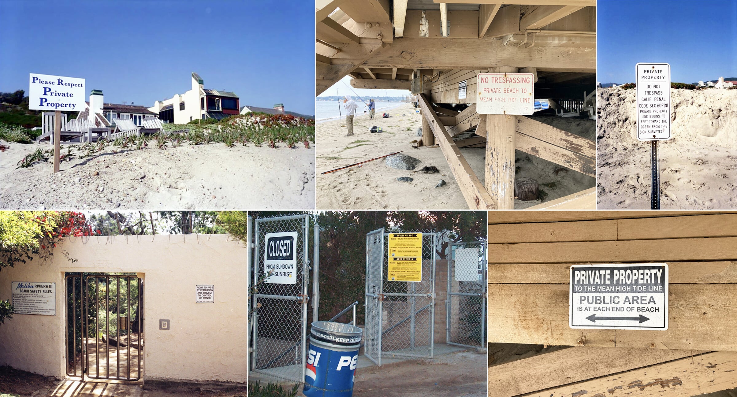
I was there with Bautista as a volunteer for the day. As we put up tables and umbrellas, she eyed the “Private Beach” sign and told me more about the backstory. At the last Mujeres de la Tierra event in this location, she said, shaking her head, there was another sign, “even bigger,” placed directly on the sand. 1 Many surrounding houses had similar signs, likely distributed by their homeowners’ association, that read, “Private Property to the Mean High Tide Line — Public Area is at Each End of Beach.” The signs were obviously meant to intimidate beach goers and give the impression that they were doing something wrong by sitting on the beach. Indeed, I watched as that message was reinforced in a variety of ways.
Around mid-morning, a man appeared who Bautista and her staff had seen before and nicknamed “Smiley.” An older White man, casually dressed, Smiley stood on his deck scowling. Then, after the families arrived, and we started passing out beach towels and sunscreen, fitting the kids for wetsuits, and sharing coffee and donuts, Smiley started taking pictures. Like the home’s signs, the gesture was meant to intimidate. Later in the afternoon, a uniformed private security guard passed through. He mostly ignored us, but he made a group of local fishermen not far from our tables move their poles and coolers a few feet closer to the ocean.
I was struck by how much surveillance was packed into a small strip of sand.
Given that the event lasted only a few hours, I was struck by how much surveillance was packed into a small strip of land and directed toward families with children — people who were doing nothing malevolent. Bautista was less surprised. In fact, she’d come prepared. Mujeres de la Tierra had asked a Mountains Recreation and Conservation Authority ranger to also attend the event, so that if a confrontation escalated, the ranger could clarify what was public land and what was private. The ranger, Evan Sichan, took his job seriously. He had maps loaded onto his phone and was prepared to defend our right to be there. He was also cognizant of the racial dynamic between Malibu homeowners and Mujeres de la Tierra’s beachgoers. And yet, his job was not as clear-cut as it might seem. Sichan was tasked with defending a property boundary that is not fixed in place. In fact, there is no firm line between public and private land on the California coastline.
A foundational assumption of private property law is that land is static enough to be mapped, gridded, and divided. The trouble with this assumption is that the space where the ocean meets the sand is ambulant — ambulant always and by definition, although as climate change accelerates, the degree of ambulation increases apace.
The method sanctioned by the U.S. Supreme Court for calculating the boundary between public coast and private land is practically useless in the State of California today. A 1935 court case, Borax Consolidated Ltd. v. City of Los Angeles, determined that the boundary is set by the mean high tide line, calculated over a period of 18.6 years. 2 The number 18.6 was determined by the court to be the length of time in which there might be a measurable change in sea level. 3 The ruling offers the illusion of precision. Over a period of 103 months and six days, simply measure where the mean high tide intersects the beach (a calculation that combines the horizontal reach of the tide with the vertical depth of the tide), draw the average, and there it is. But for a variety of reasons, that’s not what happens in practice.
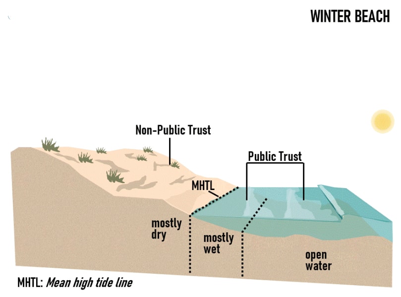
The most obvious stumbling block is that water levels are rising much faster today than in 1935. An average mean high tide calculated over 18.6 years is not a reliable indication of water movement in the future, or of the associated accretion or erosion of the coast. Second, demarcating a boundary via years of surveyor calculation is expensive and time-consuming. The required research entails not just tide calculations, but complicated historical analysis to determine what changes to the shoreline are “natural” as opposed to caused by humans. The agency that would make these calculations, California’s State Lands Commission, is thin on staff and resources, such that they generally only make an official declaration of the mean high tide line when it is required for settling a legal dispute. 4 Underfunding has left the agency reactive rather than proactive, leaving large stretches of the coast open to practical uncertainty.
If you’re standing on land that looks like it was recently wet, you’re probably on public beach.
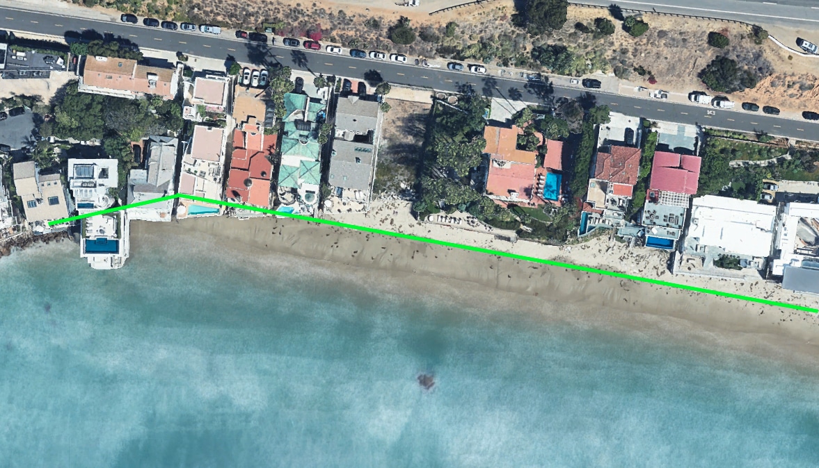
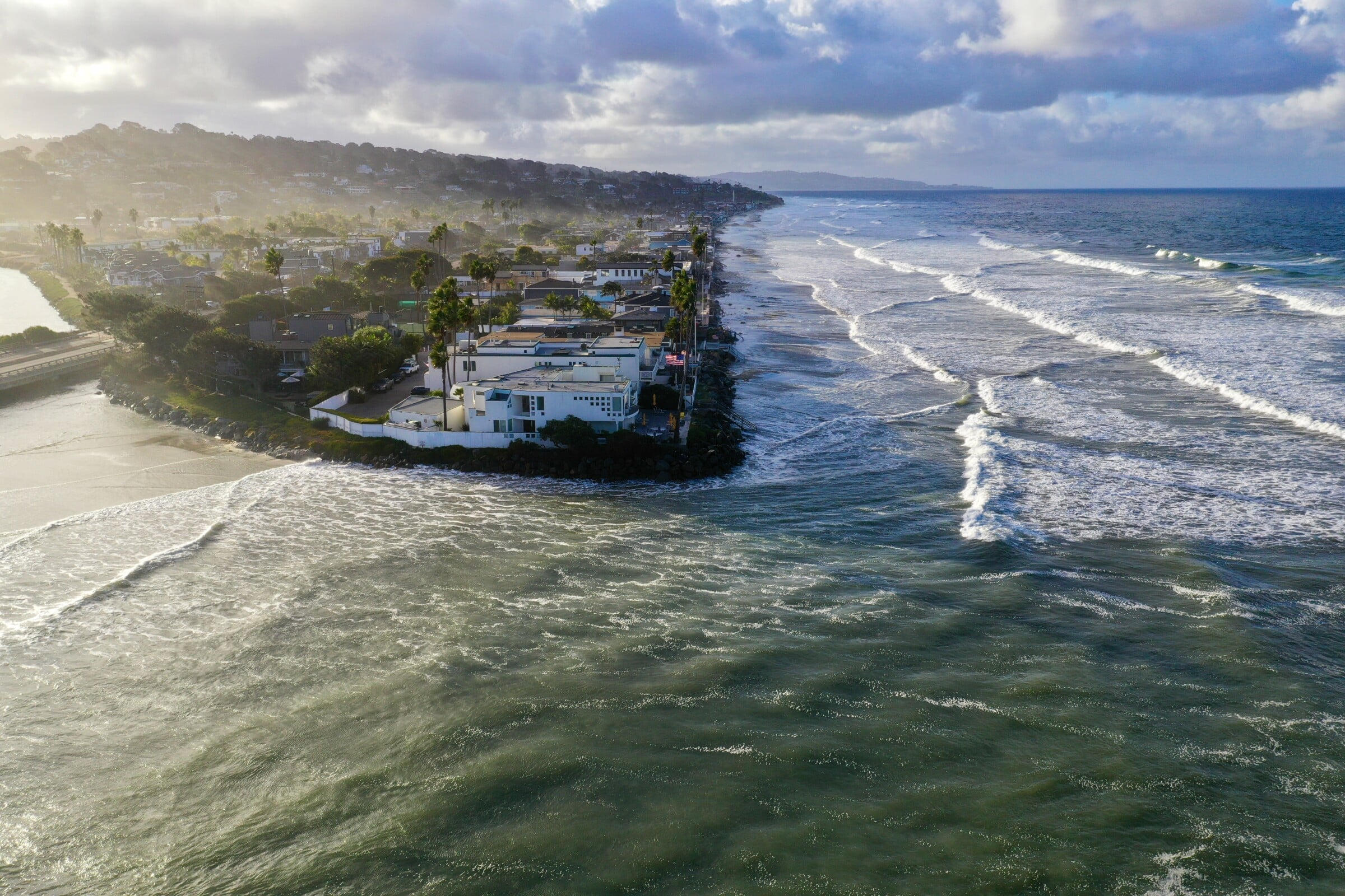
Third, public space in many cases extends beyond the mean high tide line. In Malibu, and many other parts of California, beachfront homeowners use an expanded public beach as a bargaining chip when seeking home improvements. That is, they set up a lateral easement for the dry sand in front of their property in exchange for permission to make improvements on their home — a new deck or an extra bedroom — which would otherwise not be permitted. From above, Escondido Beach’s property lines look like a set of crooked teeth, with random strips of private land smashed between public space. Were you to walk along the beach, keeping a perfectly consistent distance from the water, you would pass through swaths of private land and swaths of public land. As the Los Angeles Times put it, “it’s impossible to tell which houses have these easements, and which do not, without carrying a sheaf of maps and property records.” 5
In other words, while you might imagine a line that uniformly follows the contours of the land, or maybe you imagine a line that’s not uniform, but was nonetheless drawn carefully by geographers and surveyors, the actual line is jagged, piecemeal, and sometimes seems to disappear. Hard lines determined by lawsuits and easements are interspersed with long stretches of no line at all. The law’s extreme ambiguity has stripped away its utility; thus state officials like Evan Sichan use instead a legal rule of thumb that is rooted in the public trust doctrine: if you’re standing on sand that looks like it was recently wet, you are probably on public beach.
Public trust doctrine is one of the guiding principles of California coastal law. Public trust doctrine, which is part of United States common law, acknowledges that not all the world is subject to private ownership. The general idea — originating from Roman Emperor Justinian’s declaration that the “the air, running water, sea, and sea-shore are all common property” — is that the public has a right to the space where water moves. 6 Naturally, this makes the shoreline boundary between public and private ambulant and imprecise. Public trust doctrine honors the nature of the ocean, rather than the demands of private property.
The entire United States is heir to the public trust doctrine, but it’s a particularly central concept on the coastlines of California, Hawaii, and Puerto Rico, where private development more regularly intrudes on public trust lands and where wave action creates more variance in tide lines. In Puerto Rico, the public has an explicit right to any land touched by the ocean, and there is a coordinated and ongoing campaign to fend off any private development along the coast that impedes that right. 7
What if we agreed that the purpose of property is collective well-being and enrichment of the commons?
Using the slogan “Las Playas Son del Pueblo” (“Beaches Belong to the People”), the movement has resulted in protests, beach occupations, and pointed criticism of American-led capital. 8 In Hawai’i, local activists have similarly fought to preserve the public trust doctrine by defending the ambulatory character of the public-private boundary. A 2006 Hawai’i Supreme Court decision, Diamond v. State, ruled in the activists’ favor by setting the public-private boundary as the “highest wash of the waves,” rather than the line of plant vegetation, which private developers had promoted as a more efficacious boundary. 9
While each of these movements is unique and specific to its setting, they all have a similar vision. The vision is not simply a truly public coastline, but also and more broadly a reformulated understanding of the role of property in our lives, and our society. What would happen if we agreed that the purpose of property is collective well-being and enrichment of the commons, rather than disproportionate prosperity for a select few?
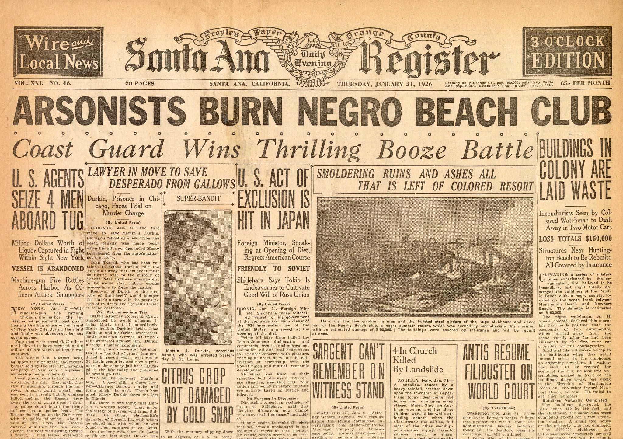
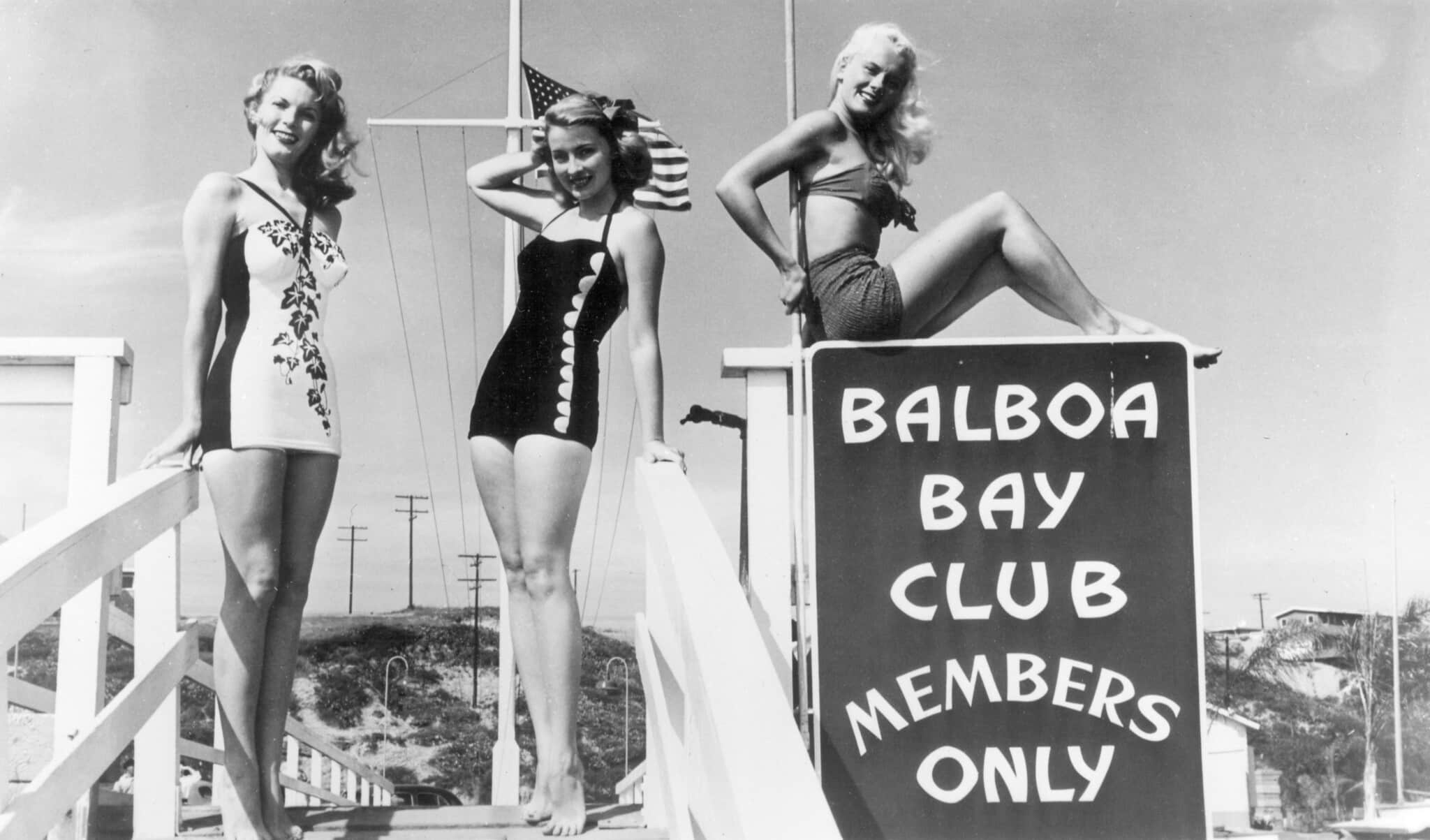
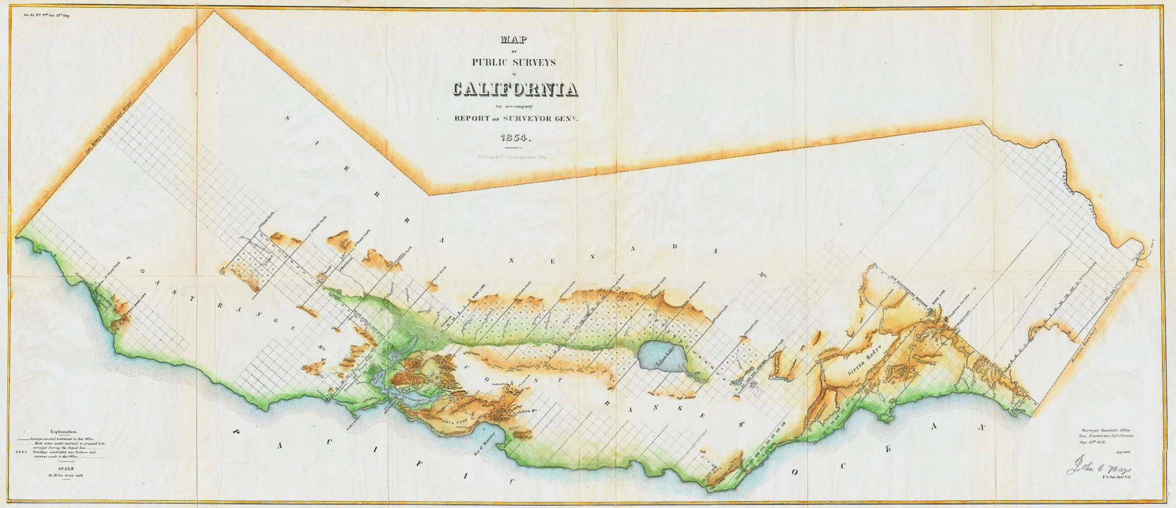
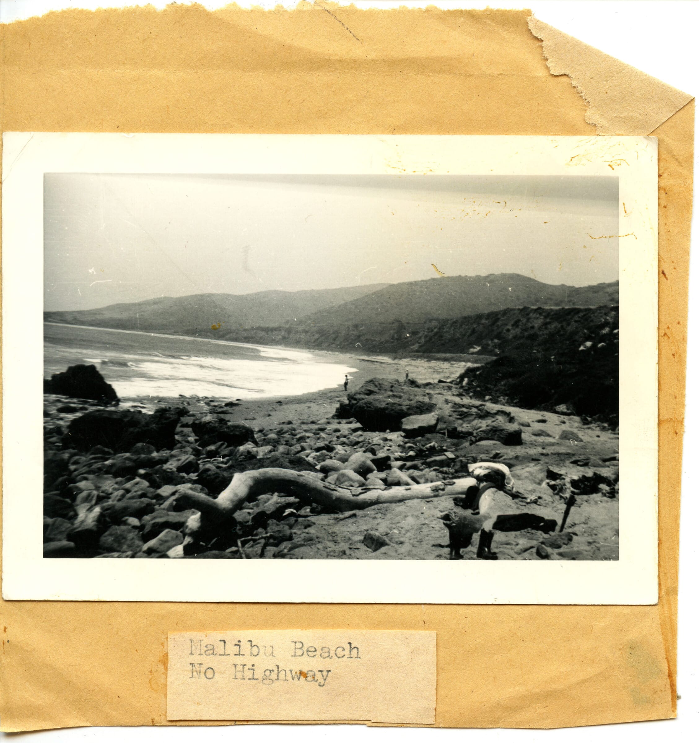
Public trust doctrine has been at play in California since statehood in 1850, but it was not until the early 1970s that state regulators formally acknowledged that claims of private ownership were threatening public access to the beach. Admittedly, California’s beaches had never been accessible to everyone. In Southern California, in the 1920s, when industrialists started to erect oil derricks along scenic coasts, property developers and Chamber of Commerce boosters protested, and advocated instead a patchwork of private and public lands that would allow drilling in some places, while also encouraging real estate investment (and tourist dollars) in other places. 10 The Shoreline Planning Association, effectively a “beach lobby,” was created to coordinate millions in state and local funding to buy private coastal land and simultaneously create pockets of public coast managed by local authorities. 11

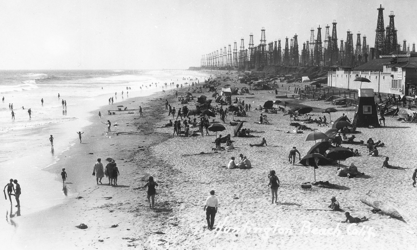
Sectors of the public deemed bad for business were intentionally excluded.
Sectors of the public deemed bad for business were intentionally excluded. As transitional, liminal spaces, beaches have historically accommodated all kinds of marginalized groups and activities, from Black families at the Santa Monica “Inkwell,” to cruising gay men, to racially integrated party-goers, to working-class adults who want to drink and gamble, to car campers, artists, and misanthropes. But the aggressive development championed by the Shoreline Planning Association aimed to sanitize the beach, creating instead, as historian Elsa Devienne describes, “a beachscape of elegant high-rises with ocean views.” Elements that were considered “undesirable,” including Black bodies, were removed from view. Particularly in areas south of Los Angeles, that vision largely prevailed, and by the late 1950s, as Devienne writes, the “informal world” of “cheap apartments and dilapidated concession stands” had “ceased to exist.” 12
In the late 1960s, however, profiteering, speculation, and overdevelopment along the coast started to face stiff resistance. 13 It had become obvious by then that development was displacing working-class coastal communities and encroaching upon lands that should be public. High-density real estate had altered shoreline vistas and coastal freeways had expanded practically onto the sand. People sunbathed within sight (and smell) of major oil and gas company operations.
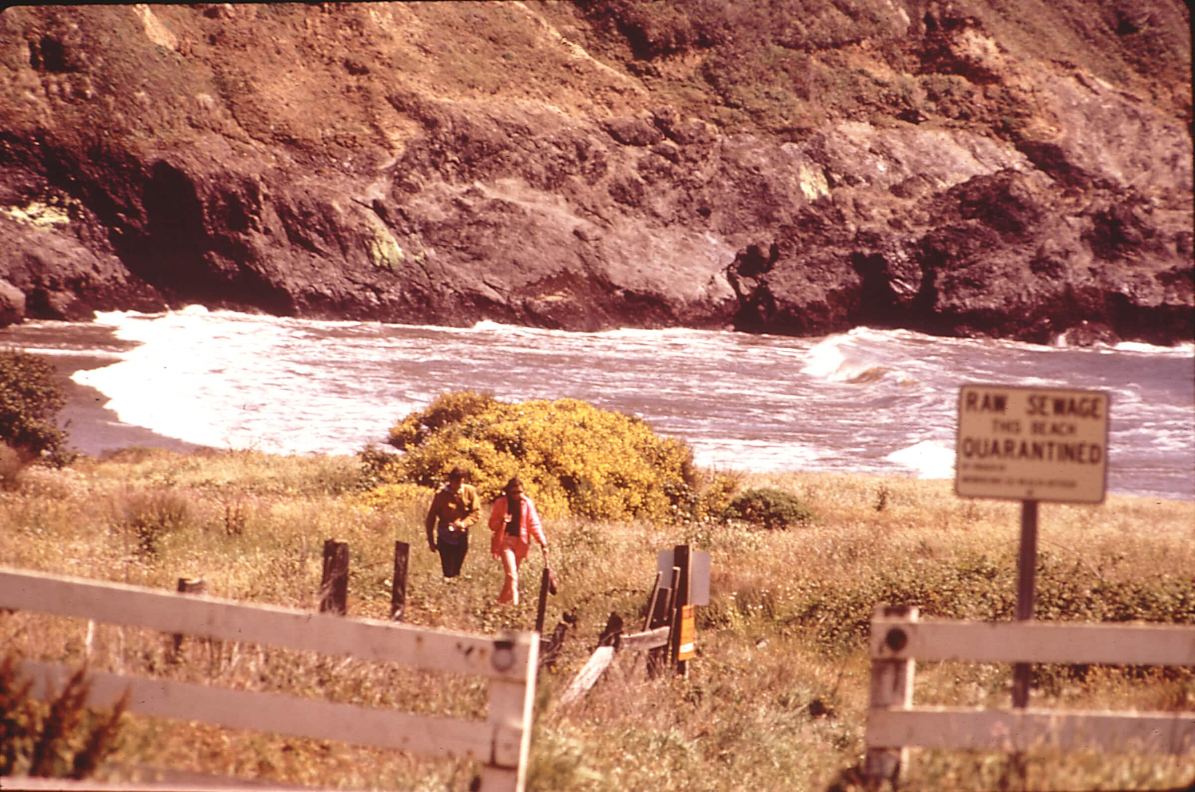

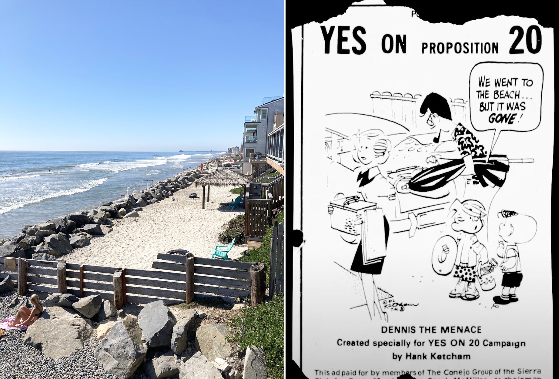
Then, in 1969, a catastrophic oil spill off the coast of Santa Barbara shocked the country. Photographs of dead wildlife and mucky sand inspired the first Earth Day, and Californians began paying closer attention to the environment. With the slogan “Save Our Coast,” people from all over the state — Sierra Club activists, young surfers, the League of Women Voters, students at Humboldt University, Chicana grassroots community activist Pat Herrera, and many others — joined the movement for a ballot initiative known as Proposition 20, mounting what may be the most significant campaign in history against “coastal capitalism.” 14 One of the movement’s champions was James Mills, California State Senate President Pro Tem. He conveyed the heart of the issue by reciting an 18th-century English rhyme:
The law locks up both man and woman
Who steals the goose from off the common,
But lets the greater felon loose
Who steals the common from the goose. 15
As Mills’s couplets indicate, the movement was centered on the concept of the commons: an unimpeachable right to public space shared by all. The idea was salient enough to draw a broad coalition, and in 1972 Proposition 20 was passed. Victory meant the creation of a new government agency, the California Coastal Commission (hereafter “the Commission”), tasked with prying back public control over a coastline subsumed by privatization. The Commission’s first job was to submit to the legislature a plan for protecting the coast; this plan was adopted as the 1976 Coastal Act. Today, the Act and the Commission together protect the public’s right to access. The Act articulates the right, and the Commission enforces it, adjudicating when necessary. 16
The Commission was vested with a great deal of power, though in the 1980s and ’90s it struggled due to obstructionist Republican state leadership as well as internal controversy and corruption. 17 These days, however, following two decades of Democratic control, the Commission enjoys significant authority and relative support from state government. 18 What the Commission does not have is the method or means to resolve the fundamental ambiguity of a migratory coastline. In fact, defending this ambiguity is part of its mandate, and part of the legal precedent that informs its work.
A case heard by the Rhode Island Supreme Court in 1982 perfectly expresses the ambiguity the Commission is mandated to protect. The case was brought by a homeowner, Wilfred Kay, who had asked local police to arrest a group working on a beach cleanup in front of his house for trespassing. The beach litter crew argued that they were on public sand. The court found that trespassing not only didn’t occur, but couldn’t have occurred. The volunteers had one understanding of where the tide line was located, and the property owner had a different understanding, but neither were precise enough to be actionable. There was no definitive line to unlawfully cross, and thus no “trespass.” Moreover, the court ruled that even if the line could be precisely measured, it couldn’t be consistently and clearly demarcated given the topography of a beach. 19
The court found there was no definitive line to unlawfully cross, and thus no trespass.”
The logic of the ruling is clear enough, but enforcing property laws where there is no stable property line is extremely complicated and contentious, particularly in California, where coastal property is so valuable. California coastal real estate is worth approximately $1.5 trillion, just under the GDP of Spain. 20 Property owners tend to be at odds with the Commission, though their degree of antipathy varies. Some are annoyed by the inconveniences of an imprecise property line. Others are outraged by what they perceive as unlawful interference, arguing that the Commission’s involvement in private property violates the California Constitution. 21 In general, no one explicitly opposes public beach access, though many take actions that curtail it.
One of the key cases that informs ongoing California arbitration is known as Lechuza. 22 Lechuza Villas West was a Malibu property development group that, in 1990, submitted plans to the California Coastal Commission to develop a series of beachfront homes on a picturesque stretch just north of Broad Beach. After purchasing the site, Lechuza asked the State Lands Commission a seemingly straightforward question: How much land do we actually own? At first, State Lands replied that the planned homes “appear to be located landward of those surveyed mean high tide lines known to us at this time,” i.e. the land you intend to build on is all yours. 23
Then the state authorities changed their mind. New studies of the tidal boundary — some commissioned by Lechuza Villas West and some conducted by the Coastal Commission — showed that on regular occasions the tide moved in such a way that the land sold to Lechuza included some bits of public land. As State Lands phrased it, “There is now a substantial indication that the State’s sovereign ownership has extended to land on which portions of the project would be located.” 24 State Lands declined, however, to draw a specific boundary, explaining that the task would be too onerous. They argued that existing studies were sufficient for making a reasonable estimate of the mean high tide line and that “budget cuts” and “staff reduction” made an exact demarcation infeasible.
Frustrated with this answer, Lechuza Villas West took the case to the Court of Appeals. They argued that an ambulatory property boundary is not practical for developing private land, and that without the certainty of a discrete property line, citizens are effectively denied their right to own property. The court disagreed, finding that while existing studies on the tidal boundary might not have the precision of a set line, they were sufficient for making a judgment. And the ruling further reinforced the idea that the boundary between public and private space moves over time. In the words of the presiding justice, the contested stretch of Lechuza Beach “belongs sometimes to the state and sometimes to Lechuza.”
The ruling reinforced the idea that the boundary between public and private space moves over time.
Lechuza scoffed at the notion that land could “sometimes” belong to them, and reiterated their position that only a fixed public-private divide guaranteed the appropriate legal protections. The court again disagreed, countering that although there was no fixed, permanent line, the ambulatory character of the line was fixed and permanent enough. Although the issue was not fully resolved, Lechuza provided some clarity about how California state law interprets the compromise between public trust lands and private property. That compromise and clarity, however, would prove to be short-lived. Over the last decade, climate change has brought the issue back with a vengeance.
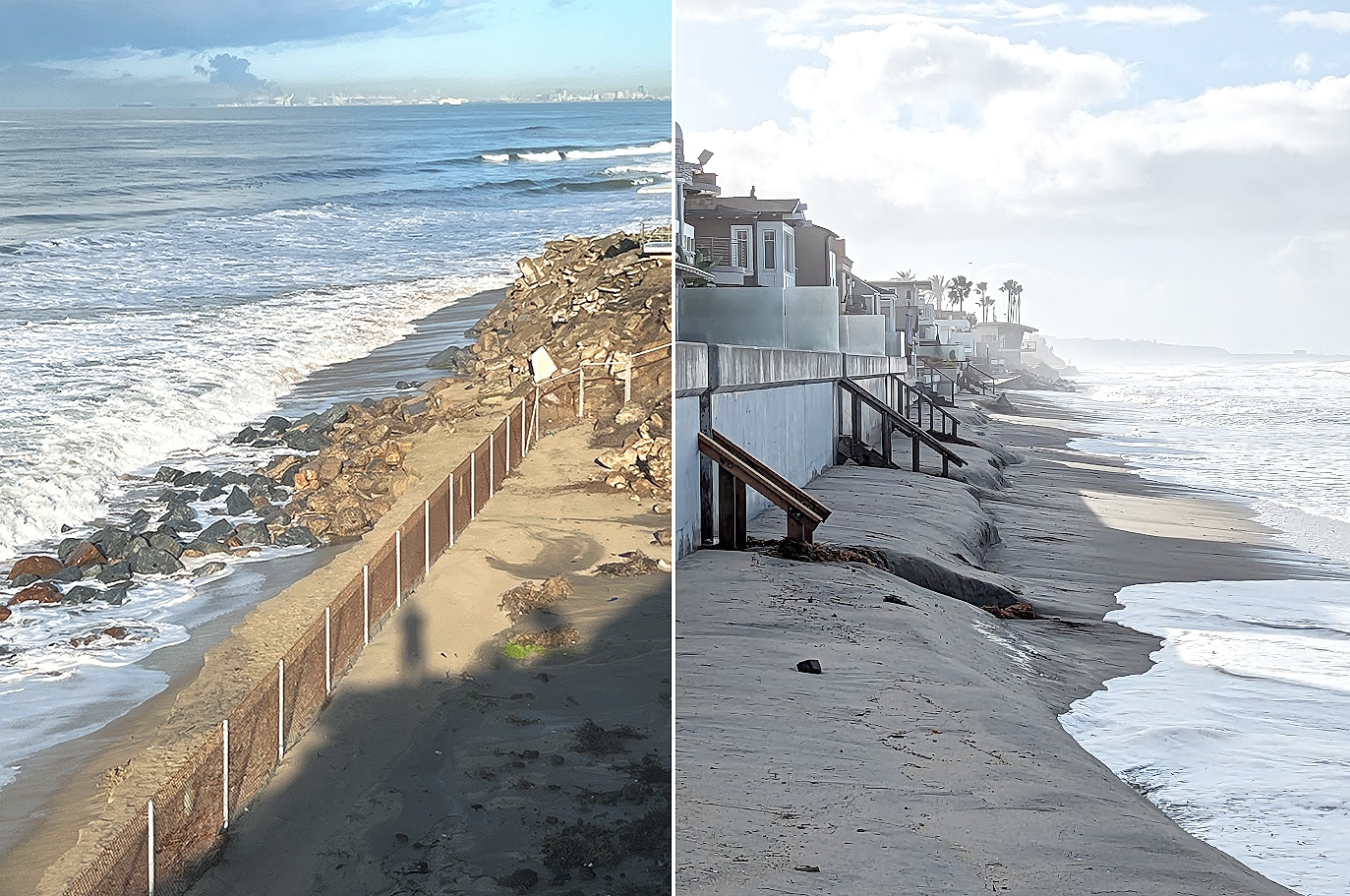
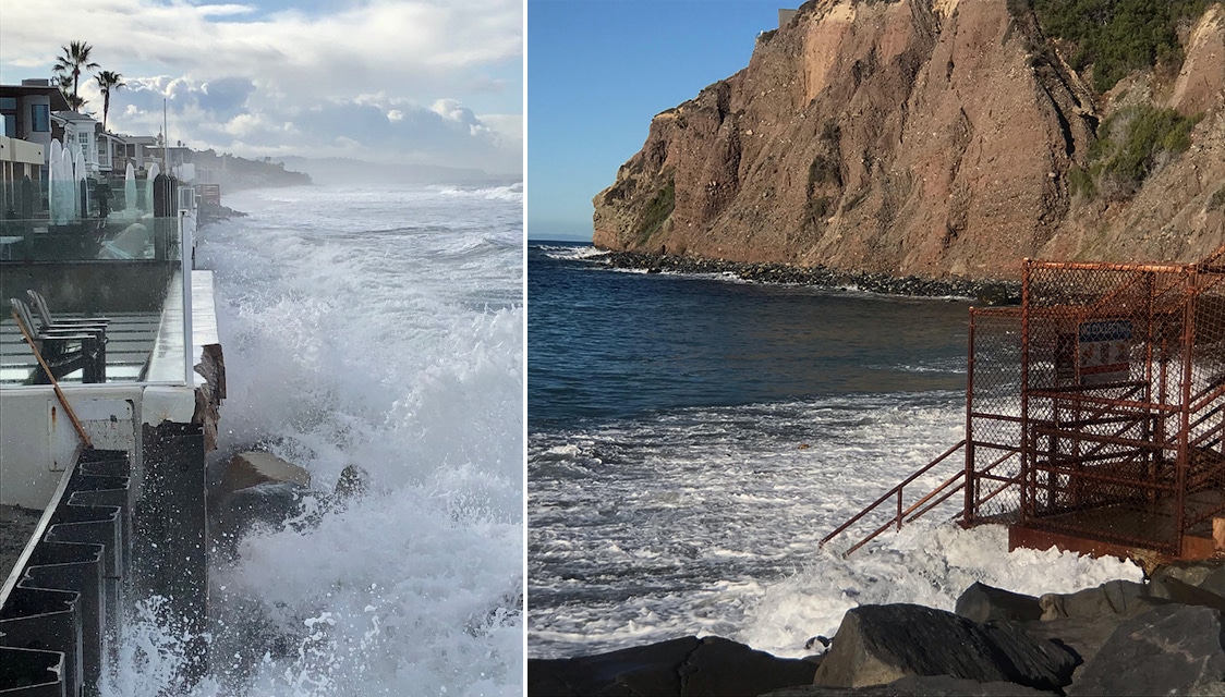
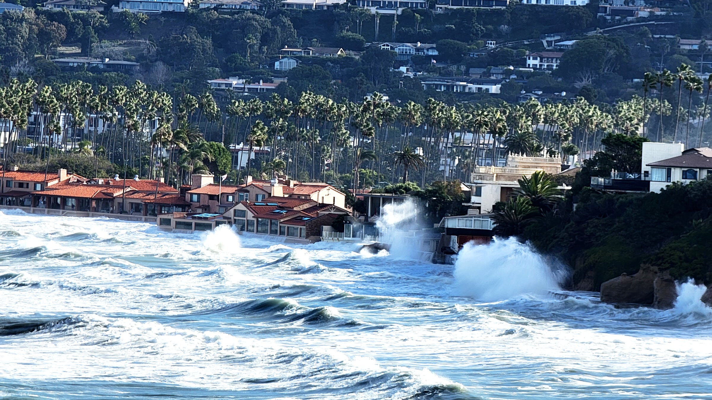
Up and down the coast, rising sea levels are exacerbating public trust conflicts. As the ocean moves inward, the number of “choke points,” or geographic spots where public land and private property comingle, are increasing, and so are the efforts of property owners to protect their structures from damage. 25 This effect is often referred to as “coastal squeeze.” The fiercest arguments about coastal squeeze tend to play out in administrative arbitration concerning engineering structures, such as sea walls.
These legal disputes may seem dry and arcane, but they speak to the heart of the conflict between private property and public beach.
These legal disputes may seem dry and arcane, and only relevant to the property in dispute, but in fact they speak directly to the heart of the conflict between private property and public beach. At a 2023 California Coastal Commission meeting, for example, I watched a very tense back-and-forth about one such case of coastal squeeze. Gary Grossman, a real estate developer in Pismo Beach, wanted to repair a seawall that protects his personal home from the ocean. When Grossman first built the wall, in 2003, the Commission raised no unusual objection. It was squarely located on Grossman’s property. The wall was designed to last for 50 years, but wave action and storm surge had deteriorated it much faster than its engineers expected, and now it needed to be rebuilt.
In fact, in the twenty intervening years, the tideline had moved so significantly that the seawall was now subject to further public trust protections. If Grossman wanted to rebuild his wall, he could, the Commission ruled, but he’d need to pay the State of California $1.3 million as a mitigation fee. This cost would be on top of the cost of the wall itself. 26 The price tag, the Commission explained, was not only because Grossman’s wall encroached on sand now owned by the public, but also because the structure would potentially circumscribe the emergence of new public land in the future. Defending their position, the Commission wrote that “armoring” projects like Grossman’s have “insidious outcome[s].”
Over time as the seas rise, the mean high tide elevation is ambulatory. …However, if there is hard armoring, the beach and shoreline will not be able to migrate, and the public may be prevented from accessing land that would otherwise become public trust. In other words, public trust resources are reduced, and their natural creation thwarted by projects like this. 27
Grossman’s lawyers vehemently disagreed and promised further lawsuits. In early 2025, both parties agreed to a revised version of the armoring project: a smaller wall, with a lower mitigation fee.
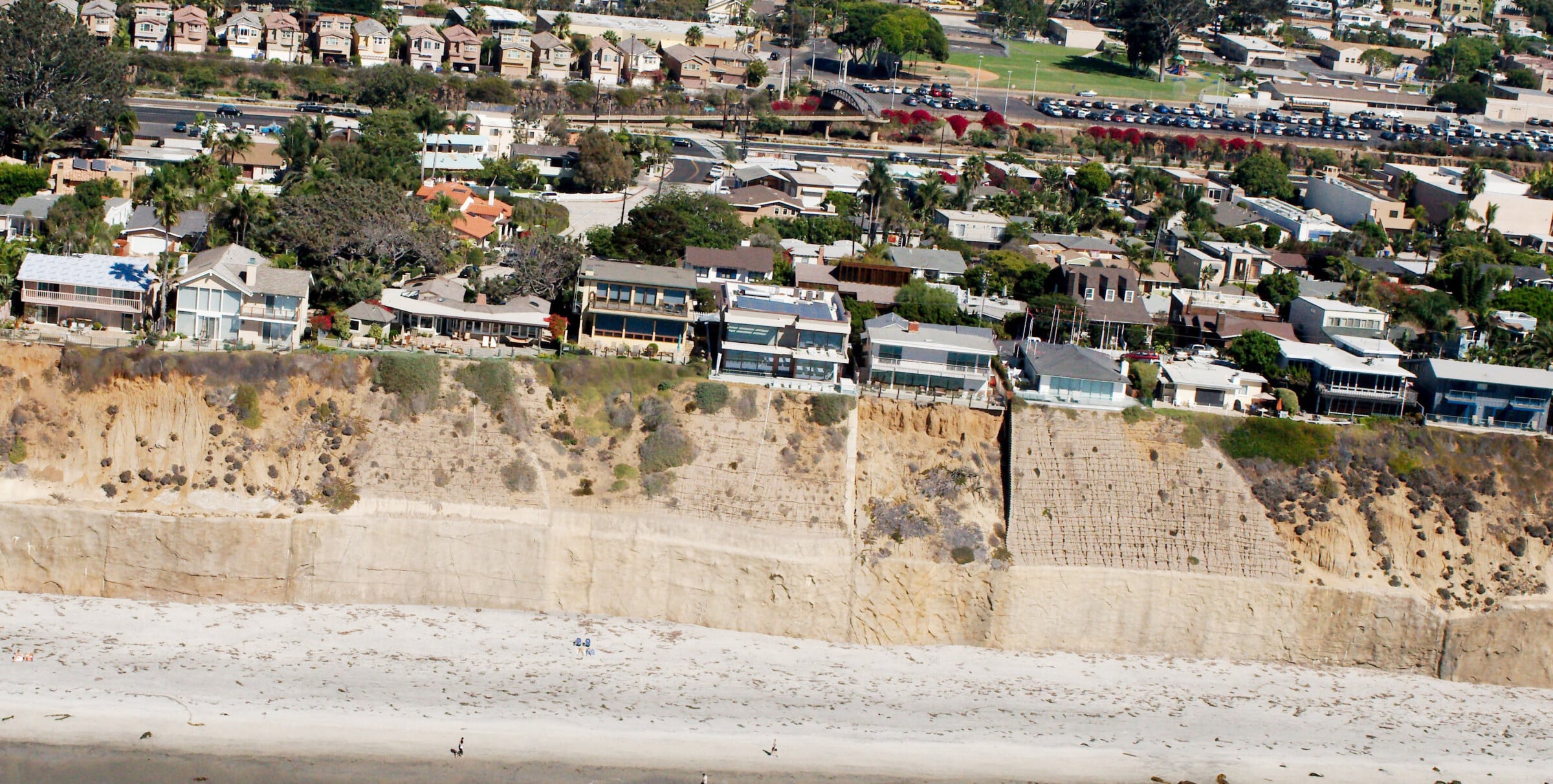
Another dispute, ongoing now, concerns the issue of replenishing the sand on Malibu’s Broad Beach. The backstory: most postwar development of Broad Beach took place during a quiescent period of storm activity. But then, in the late 1970s, El Niño climate patterns brought heavier storms, which, alongside the loss of sand supply from coastal and upland urbanization, caused significant erosion. 28
Between 1974 and 2000, the tide moved landward and the distance between water and hard land significantly decreased.
Between 1974 and 2000, the tide moved landward at a rate of two feet per year; as a result, the distance between water and hard land decreased by 65 feet. The diminished beach offered homeowners much less protection from the waves. In 2010, Broad Beach residents applied for an emergency permit to build a 36,000-ton rock seawall to prevent further erosion. The seawall was approved by the Commission, but Broad Beach homeowners knew it wasn’t a real solution. The following year, seeking a more permanent fix, 121 homeowners designated Broad Beach a “Geologic Hazard Abatement District” and proposed a $20 million sand replenishment and rock revetment project. To the Commission, they argued that such extreme measures were necessary, given that their homes were under existential threat. In anticipation of the Commission’s concerns, they also said that their plan was not a threat to public access, but the only way to preserve it.

In evaluating the permit application, the Commission noted that although in the long term the project might potentially improve public benefit, in the short term, it “encroach[ed] on public tidelands.” 29 They decided to approve the permit, with conditions. If residents of Broad Beach wanted to subsume public land, they needed to pay mitigation fees, open access routes, and generally improve the public’s ability to visit the beach. The residents agreed, and the project tentatively moved forward. Then it stalled again, for different reasons. Sand is now more expensive than was originally budgeted, and Broad Beach homeowners faced lawsuits from adjoining cities over the toxins and pollution of an “estimated 44,000 truck trips along the Pacific Coast Highway” that will be required “to deliver sand to Malibu.” 30
Property owners have also tried a different tack, which is to work alongside agencies at different levels of government, finding spots where interests dovetail. The goal is not necessarily to protect one specific property, but to suss out where money and lobbying can steer coastal policy in ways favorable to property owners. A group in Solana Beach, a scenic coastal strip north of San Diego, have had considerable success working in this way.
The situation was described to me by a Solana Beach homeowner, who asked that I use a pseudonym. Tom’s home, like those of his neighbors, was built on a 70-foot sandstone bluff that drops off to a sandy beach. He explained that erosion is lessening the amount of sand that covers the lower sections of the bluff, which makes the upper sections less stable. Minute disruptions — a landing bird, for example — can trigger significant collapse. Coastal bluff erosion is threatening the structural integrity of about 50 private homes, all built on top of the bluff.
One immediate remedy is to replenish the sand on the beach, which slows bluff erosion. San Diego County has already done a great deal of beach replenishment; in 2012, a regional association of county governments called SANDAG spent $26 million to pump in 1.5 million cubic yards of sand. Less than a decade later, the beach needed replenishment again. This time SANDAG worked with other state entities, including Caltrans, California State Parks, and the City of Encinitas, to install a temporary pipeline that funneled 63,000 cubic yards of sand — the equivalent of nineteen Olympic-sized swimming pools — onto Cardiff State Beach, just north of Solana Beach. (Although none of this sand was placed directly in Solana Beach, the drift patterns of sediment worked in their favor.)
Erosion threatens the structural integrity of numerous private homes. One remedy is to deposit more sand on the beach.
By early 2024, however, it was clear that 63,000 cubic yards of sand was still not enough. This time, Solana Beach property owners sought a longer-term fix, launching an ambitious 50-year project to replenish sand on a regular schedule. Every ten years, the city will dredge 700,000 cubic yards from offshore deposits, construct a temporary pipeline to transport the sand from the ocean to the shoreline, and use heavy machinery to distribute the sand evenly across the beach. The funding for the project — about $50 million total — comes primarily from the federal government via the Army Corps of Engineers, but the applications and coordination are driven by lobbying at the local level. As Tom put it, “The locals have to want it enough to pay for some fraction of it.” 31 In addition to the money commitment there is the time — time spent coordinating local communities, city and state governments, and the Army Corps. When I asked Tom about the process, he shook his head, incredulous at the thicket of bureaucracy. Another homeowner confessed the same: he hadn’t expected to spend so many hours protecting his home from the sea.

Five decades of transplanting sand is an immense intervention, but it’s only half of what’s needed to stabilize the Solana Beach homes. The other half is a massive seawall along the toe of the bluff, about 35 feet high and four feet thick, stretching the length of almost six football fields. Tom explained that when he first moved to Solana Beach in the 70s, none of the bluff was armored. “But then we had a couple of really nasty winters.” 32 Storms prompted homeowners to start seeking bluff protection. 33
As had happened in Malibu in the early 1980s and again in the early 2000s, heavy El Niño storms and high tides slammed the Solana Beach bluffs, creating the hollowed-out caves that destabilize everything above. “Once you get to that point,” Tom explained, “the bluff has ‘failed.’ It hasn’t fallen down, but it is structurally unsafe.” 34 The seawalls buy time for each homeowner to fill in the eroded sand in their section of the bluff. Sand is brought in by the truckful and dumped onto the shorn bluff face. The seawall, in combination with more sand, fixes the lower bluff in place, at least temporarily.

Ongoing since the 1980s, the task of building the Solana Beach seawall has been as time-consuming and bureaucratic as the sand dredging project, if not more so. The seawall is not in fact one wall, but a patchwork of walls that has slowly unified into a whole. The Commission generally does not approve seawalls that span multiple properties, because they prefer to weigh each permit on a case-by-case basis. The process is piecemeal on purpose; as Commission staff told me, it should not be easy to engineer and manipulate the public coastline for private benefit.
Nonetheless, through a combination of time, money, persistence, and coordination, Solana Beach homeowners have managed to build a single continuous wall. As Tom and I walked along the beach, I eyed the bluffside and asked if the homes we were looking at were technically allowed to have seawalls.
It should not be easy to engineer the public coastline for private benefit.
I had heard stories about Solana Beach homeowners using workarounds and dubious legal loopholes. In response, Tom told me about a specific case in which a home was initially denied the right to a seawall. The owners had signed a deed restriction, waiving in perpetuity their right to build a seawall. Then there was a heavy storm, and their back patio fell down the bluff. Despite the restriction, they applied for a seawall permit and were, predictably, denied. But then the owners on either side of the home sued the Commission, saying that their neighbor not having bluff armoring was a threat to their property rights; the permit came through. Later, in the Commission’s video archive, I watched the permit hearing. Nobody at the Commission explicitly mentioned collusion, but several Commissioners seemed incredulous. “It just smells funny to me,” one said. 35 Tom smiled while he told me the story. “The truth,” he said, is that the homeowners were “all sort of working together.” 36
As I walked with Tom, it was clear that his feelings of precarity and persecution at the hands of the Commission were deeply felt. And he’s not wrong that the Commission’s process can be opaque and slow. I understood his general concerns, but I also thought there were flaws in his thinking. Tom believes that by adding sand to the beach and armoring coastal bluffs, public and private interests can coexist in perpetuity. This seems an overly sanguine view of the future. The consensus among coastal scientists, state regulators, and environmental lawyers is that consistently acceding to homeowners’ requests will curtail public beach access and increase climate vulnerability. 37 What happens when the amount of sand required triples, and the costs grow five times? Research suggests that’s where we’ll be in 2050. 38 How long should the public subsidize the right of a private homeowner to stay in place?
In May 2023, a nonprofit called Smart Coast California hosted a policy summit in a hotel ballroom in Newport Beach. Smart Coast California is an offshoot of the California Association of Realtors, and they’ve become surprisingly influential in shaping sea level rise policy. About 200 people sat at circular tables under an ornate chandelier. The room skewed older and White. Most were real estate brokers. Out of the 20 odd tables, there were two where the more traditional policy wonks clustered: Coastal Commission staff, Surfrider Foundation representatives, councilmembers from coastal cities. Walking around the ballroom, I met agents from Marin County, Half Moon Bay, Rosewood, and Cambria. When I asked people why it was important to attend, some said they wanted to learn; others said they wanted to protect the “coastal way of life.” One woman told me she was there because it was time to take climate change seriously.
The day was a back-and-forth about how rising sea levels should affect private versus public interests. No one disputed climate change or sea level rise, and everyone agreed losses were coming. The question was who should bear the losses. The topic came to the fore during a presentation by Charles Lester, former executive director of the California Coastal Commission.39
What is our shared public interest in the shoreline?
Showing images of a disappearing public coastline, Lester said, “I think we’ve been too narrow so far, just focusing on risks to development. … The question is: What is our shared public interest in the shoreline? And how do we value it?”
With the goal of making these debates less contentious in the future, Lester explained, state officials had begun to include explicit language in the deeds to properties that will likely be impacted by rising sea levels. The small print effectively stipulates that if tensions arise, the public’s right to the coast will trump private rights of protection, even if that requires removing existing structures. Lester shared sample language:
By acceptance of this permit, the applicant further agrees … that the landowner(s) shall remove the development authorized by this permit … if the development is no longer located on private property due to the migration of the public trust boundary.
The real estate brokers read Lester’s slides and shifted in their seats.
Later that day, Stanley W. Lamport, a longtime coastal property lawyer, made the counter-argument. The public, he said, does not have a right to require private homeowners, wealthy though they may be, to bear the cost of public beach loss inflicted by the ocean. Property owners were being asked to mitigate the impact of tidal events they had played no part in causing. “When we talk about coastal squeeze,” Lamport concluded, “it’s not the structure that is causing the impact.” What he meant is that the public beach is eroded by the ocean, not by the home; the ocean is at fault, not the homeowner. As one agent put it later to me, while sipping a drink, “Why should homeowners have to deal with a problem they didn’t cause?”
There was little sign of compromise over the course of the day.
There was little sign of compromise over the course of the day. Everyone was cordial, but the two groups stayed fixed in their opposite perspectives. There was some discussion about how to relocate particularly vulnerable structures, and everyone seemed in favor of including a broader range of stakeholders in coastal planning. But the most lauded presentations argued that with some creative engineering (e.g., artificial reefs) coastal development doesn’t need to change much at all. The core conflict remained.
Property disputes on the California coast are a reminder that multiple things can be true at once. Wealthy beachfront homeowners can perpetuate a longstanding system of racial and class hierarchy — terraforming the world around them to advance solipsistic property interests — and they can also be exercising a basic human impulse to preserve security. Sand replenishment can stabilize an eroding shoreline, and it can also be an increasingly untenable waste of time and money. These problems are not easy or straightforward and, in many aspects, they are new problems, with few historical precedents.
Some call for a rapid retreat from the coast. The reasoning is persuasive, but it does no service to anyone to downplay what retreat entails. Intentional retreat — distinct from the more common occurrence of state-mandated, forced relocation — means not just a transition to something new, but an unwinding of dense agglomerations of urbanization, community building, and place attachment that have accumulated and stiffened over a century or more.
What we need now is a revitalized discussion about a new Coastal Act.
On a literal level, retreat means moving structures away from the water’s edge; but emotionally, politically, philosophically, it means much more. It’s what Adam Tooze, writing on energy transition, calls a “deliberate exit.” 40 Rather than building on top of a world that already exists, we undo that world, root and branch, and do something different. As Tooze points out, deliberate exits are an aberration. They happen, but rarely. 41
Any kind of just exit will require political leadership in Sacramento. 42 Despite the challenges of implementation, Proposition 20 is one of the most successful environmental policies in California history. Prop 20 passed through grassroots energy, but also through the efforts of elected politicians and their staff — Peter Douglas, Janet Adams, Alan Sieroty, John Dunlap, and many more — who saw the long-term benefits of codifying what it means to balance public and private interests. But today, the Coastal Act is a relic of an age when climate change was not in the public consciousness. What we need now is a revitalized, statewide discussion about a new Coastal Act.
What could that discussion look like, and who could be involved? First at the table would be the communities that were excluded from the creation of the 1976 Coastal Act. Tribal nations have never ceded the coastal land that is now considered sovereign territory by the state and never been meaningfully included as decisionmakers on coastal policy. For every group like the attendees of the Mujeres de la Tierra event, there are hundreds of others that do not view the coast as a part of their right to public space. In communities like Oxnard, coastal access is important, but more pressing are concerns over air quality and groundwater pollution that have accumulated after decades of heavy industry in the coastal zone.
Our challenge is collective, political, urgent. Let’s not wait for homeowners to decide their property is not worth protecting.
A revitalized Coastal Act discussion would address not just access and environmental protection, but the holistic coastal issues that matter today: housing, affordability, and public health concerns that dictate who can live a healthy and dignified life on a climate-threatened coastline. 43 While this might seem like a challenge, it is also an opportunity to rebuild and expand the coalition that backed Proposition 20. Without such efforts, the fate of the California coast will be decided in courtrooms, with lawyers and judges mediating between monied property owners and beleaguered bureaucrats.
We should not wait for homeowners to decide their property is not worth protecting. The wait will be too long. Our challenge is a collective, political one. Homeowners should be heard, but not kowtowed to, and the public in all its multitudinous diversity should be at the table. Do we still ascribe to the public trust doctrine — the idea that the public has an unimpeachable right to “the space where water moves”? The Coastal Commission has tried to balance the rights of access with the rights of ownership, but climate change is testing the limits of what was already a fragile compromise. How we respond in the next few years will not just shape the coast, but also our shared understanding of what should be saved as the seas rise.


_-_Geographicus_-_California-landsurvey-1854.jpg)
If you would like to comment on this article, or anything else on Places Journal, visit our Facebook page or send us a message on Twitter.